
ფაილი:Plan of the Hindu temple at Trichur.jpg
თავდაპირველი ფაილი ((633 × 712 პიქსელი, ფაილის ზომა: 157 კბ, MIME ტიპი: image/jpeg))
| ეს ფაილი მდებარეობს Wikimedia Commons სერვერზე. იხილეთ მისი აღწერის გვერდი სრული ინფორმაციისთვის. |
 |
გადასვლა ფაილის გვერდზე |
რეზიუმე
| Description |
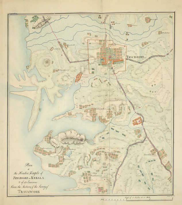
English: MacMPen-and-ink and water-colour drawing of the plan of the Hindu temple at Trichur, by John Gould, dated 11 June 1816. Inscribed on front in ink: 'Plan of the Hindoo Temple of Trichoore in Kerala & of its Environs. From the Section of the Survey of Travancore. J. Gould 11th June, 1816.'
Travancore, one of the three princely states of Kerala, consists of three natural divisions, a coastal area dotted with lagoons to the west, a midland in the centre and mountain peaks as high as 9,000 feet on the east. One of the most important Hindu complex of Kerala is the Vadakkunatha Temple at Trichur, founded in the 12th century and later reconstructed in the 19th century. The temple houses three shrines (srikovils) facing west, aligned in a single row in a rectangular court surrounded by a colonnnade. The northern one is a circular temple known as Vadakkunnatha, dedicated to Shiva. That at the south is dedicated to Rama. The central of the three temples is dedicated to Shankara Narayana (Hari-Hara), the combined form of Shiva and Vishnu and has a double-roofed circular srikovil. The conical timber roofs are covered with metal and crowned with pot finials. To the west of each shrine is an open pavilion. In the north-west corner of the outer court there is a hall for theatrical performances called kuttambalam, with an impressive overhanging pyramidal roof. The temple has preserved fine wood carvings and mural paintings.
This image falls into the public domain as it was taken in India prior to 1 January 1951, and was not published in India after that date. It is in public domain in the United States as well as it was taken prior to 1 January 1951. |
|||||||||
| თარიღი | Prior to 1 January 1951 | |||||||||
| წყარო | British Library | |||||||||
| შემქმნელი |
უცნობი |
|||||||||
| უფლება (ფაილის მეორეული გამოყენება) |
|
|||||||||
| Geotemporal data | ||||||||||
| Bounding box |
|
|||||||||
| Georeferencing | ||||||||||

ფაილის ისტორია
დააწკაპუნეთ თარიღზე/დროზე ფაილის დასათვალიერებლად, როგორც ის მაშინ გამოიყურებოდა.
| თარიღი/დრო | მინიატიურა | ზომები | მომხმარებელი | შენიშვნა | |
|---|---|---|---|---|---|
| მიმდინარე | 15:33, 28 ივნისი 2011 | | 633×712 (157 კბ) | Yon Man33 |
ბმულები
ამ ფაილზე ბმული მოცემულია შემდეგ გვერდებზე:
ფაილის გლობალური გამოყენება
ეს ფაილი გამოიყენება შემდეგ ვიკებში:
- გამოყენება bn.wikipedia.org-ში
- გამოყენება en.wikipedia.org-ში
- გამოყენება ml.wikipedia.org-ში
- გამოყენება ru.wikipedia.org-ში