
ფაილი:Pind-Meglen.png
უფრო მაღალი გარჩევადობა არ არის შესაძლებელი.
Pind-Meglen.png ((200 × 204 პიქსელი, ფაილის ზომა: 23 კბ, MIME ტიპი: image/png))
| ეს ფაილი მდებარეობს Wikimedia Commons სერვერზე. იხილეთ მისი აღწერის გვერდი სრული ინფორმაციისთვის. |
 |
გადასვლა ფაილის გვერდზე |
რეზიუმე
| აღწერა |
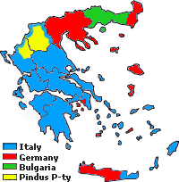
Approximative area (yellow) proposed by Alcibiades Diamandi for an eventual puppet-state called "Principality of the Pindus" in northern Greece under Italian occupation (this name was initially used in 1917 for another similar italian project). Diamandi's attempt of statehood had neither definite territory nor any borders, and never came close to realization; the yellow area in this map is likely to cover the maximalist area of the "Principality". |
| წყარო | პირადი ნამუშევარი, since a hand-drawn boundary (1942 or 1943) surimposed on a map of the Aromanians areas in Balkans, found & seen in the library of the Military Museum of Bucharest. |
| ავტორი | Spiridon MANOLIU |
ლიცენზია
| ეს ფაილი ვრცელდება Creative Commons CC0 1.0 Universal Public Domain Dedication ლიცენზიით. | |
| პიროვნებებმა, რომლებიც ერთობლივად მუშაობდნენ ამ ნამუშევარზე, გადაწყვიტეს ამ ნამუშევრის გადაცემა საზოგადოებრივ საკუთრებაში, უარი განაცხადეს ნამუშევრის ყველა უფლებაზე მსოფლიო საავტორო უფლებების კანონის იმ ფარგლებში (მათ შორის სხვა უფლებებიც) რომელიც დაშვებულია კანონის მიხედვით. თქვენ შეგიძლიათავტორის ნებართვის გარეშე დააკოპიროთ, შეცვალოთ, გაავრცელოთ, გამოიყენოთ აღნიშნული ნამუშევარი ნებისმიერი მიზნით, მათ შორის კომერციულითაც.
|
ფაილის ისტორია
დააწკაპუნეთ თარიღზე/დროზე ფაილის დასათვალიერებლად, როგორც ის მაშინ გამოიყურებოდა.
| თარიღი/დრო | მინიატიურა | ზომები | მომხმარებელი | შენიშვნა | |
|---|---|---|---|---|---|
| მიმდინარე | 17:39, 3 მაისი 2010 | | 200×204 (23 კბ) | Spiridon Ion Cepleanu | {{Information |Description={{ro|1=Principatul de Pind si Meglen, 1941-1943}} |Source={{own}} |Author=Spiridon MANOLIU |Date= |Permission= |other_versions= }} Category:Maps of Greece |
ბმულები
ამ ფაილზე ბმული მოცემულია შემდეგ გვერდებზე:
ფაილის გლობალური გამოყენება
ეს ფაილი გამოიყენება შემდეგ ვიკებში:
- გამოყენება cs.wikipedia.org-ში
- გამოყენება en.wikipedia.org-ში
- გამოყენება fa.wikipedia.org-ში
- გამოყენება it.wikipedia.org-ში
- გამოყენება lv.wikipedia.org-ში
- გამოყენება sq.wikipedia.org-ში
- გამოყენება zh.wikipedia.org-ში