
ფაილი:Map indicating Amundsen Gulf, Northwest Territories, Canada.png
Map_indicating_Amundsen_Gulf,_Northwest_Territories,_Canada.png ((395 × 370 პიქსელი, ფაილის ზომა: 60 კბ, MIME ტიპი: image/png))
| ეს ფაილი მდებარეობს Wikimedia Commons სერვერზე. იხილეთ მისი აღწერის გვერდი სრული ინფორმაციისთვის. |
 |
გადასვლა ფაილის გვერდზე |
რეზიუმე
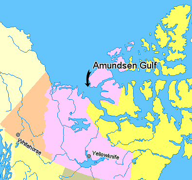
Map indicating Amundsen Gulf, Northwest Territories, Canada.
© Her Majesty the Queen in Right of Canada, Department of Natural Resources. All rights reserved.
Licence Agreement
ლიცენზია

|
The copyright holder of this work allows anyone to use it for any purpose including unrestricted redistribution, commercial use, and modification.
Usage notes:
|
ფაილის ისტორია
დააწკაპუნეთ თარიღზე/დროზე ფაილის დასათვალიერებლად, როგორც ის მაშინ გამოიყურებოდა.
| თარიღი/დრო | მინიატიურა | ზომები | მომხმარებელი | შენიშვნა | |
|---|---|---|---|---|---|
| მიმდინარე | 01:42, 21 მარტი 2006 | | 395×370 (60 კბ) | David Kernow~commonswiki | Map indicating Amundsen Gulf, Northwest Territories, Canada. {{legend|#ffff66|Nunavut}} {{legend|#ffccff|Northwest Territories}} {{legend|#ffcc99|Yukon Territory}} {{legend|#ffff99|British Columbia}} {{legend|#ffffcc|Alaska}} <br> © |
ბმულები
ამ ფაილზე ბმული მოცემულია შემდეგ გვერდებზე:
ფაილის გლობალური გამოყენება
ეს ფაილი გამოიყენება შემდეგ ვიკებში:
- გამოყენება af.wikipedia.org-ში
- გამოყენება az.wikipedia.org-ში
- გამოყენება bg.wikipedia.org-ში
- გამოყენება bn.wikipedia.org-ში
- გამოყენება bs.wikipedia.org-ში
- გამოყენება cs.wikipedia.org-ში
- გამოყენება de.wikipedia.org-ში
- გამოყენება en.wikipedia.org-ში
- გამოყენება eo.wikipedia.org-ში
- გამოყენება es.wikipedia.org-ში
- გამოყენება et.wikipedia.org-ში
- გამოყენება eu.wikipedia.org-ში
- გამოყენება fa.wikipedia.org-ში
- გამოყენება fr.wikipedia.org-ში
- გამოყენება fy.wikipedia.org-ში
- გამოყენება hi.wikipedia.org-ში
- გამოყენება ilo.wikipedia.org-ში
- გამოყენება it.wikipedia.org-ში
- გამოყენება ja.wikipedia.org-ში
- გამოყენება ko.wikipedia.org-ში
- გამოყენება ku.wikipedia.org-ში
- გამოყენება la.wikipedia.org-ში
- გამოყენება lt.wikipedia.org-ში
- გამოყენება mk.wikipedia.org-ში
- გამოყენება nl.wikipedia.org-ში
- გამოყენება nn.wikipedia.org-ში
- გამოყენება pa.wikipedia.org-ში
- გამოყენება pl.wikipedia.org-ში
- გამოყენება pl.wiktionary.org-ში
- გამოყენება pnb.wikipedia.org-ში
- გამოყენება sh.wikipedia.org-ში
- გამოყენება sl.wikipedia.org-ში
- გამოყენება sr.wikipedia.org-ში
- გამოყენება tr.wikipedia.org-ში
- გამოყენება uk.wikipedia.org-ში
- გამოყენება ur.wikipedia.org-ში
- გამოყენება vi.wikipedia.org-ში
- გამოყენება war.wikipedia.org-ში
- გამოყენება xmf.wikipedia.org-ში
- გამოყენება zh-min-nan.wikipedia.org-ში
- გამოყენება zh.wikipedia.org-ში