
ფაილი:Greece GHI Solar-resource-map GlobalSolarAtlas World-Bank-Esmap-Solargis.png

თავდაპირველი ფაილი ((1 842 × 2 063 პიქსელი, ფაილის ზომა: 1,48 მბ, MIME ტიპი: image/png))
| ეს ფაილი მდებარეობს Wikimedia Commons სერვერზე. იხილეთ მისი აღწერის გვერდი სრული ინფორმაციისთვის. |
 |
გადასვლა ფაილის გვერდზე |
რეზიუმე
| აღწერა |
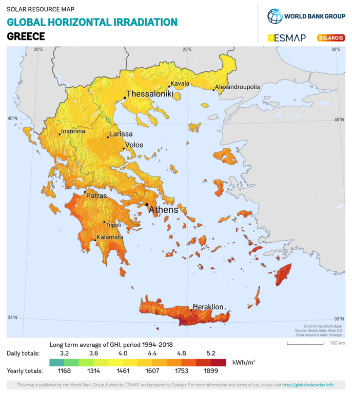
English: Solar resource: GLOBAL HORIZONTAL IRRADIATION (GHI) - this map provides a summary of the estimated solar energy available for power generation and other energy applications. It represents the long-term average of daily/yearly totals of global horizontal irradiation (GHI). The underlying solar resource database is calculated by the Solargis model from atmospheric and satellite data with 15- or 30-minute time step. The effects of terrain are considered at nominal spatial resolution of 250 m. GHI is the most important parameter for energy yield calculation and performance assessment of flat-plate photovoltaic (PV) technologies. Further details available at: https://globalsolaratlas.info. |
| თარიღი | |
| წყარო | https://globalsolaratlas.info/downloads |
| ავტორი | Solargis |
| ავტორის მითითება (required by the license) | © The World Bank, Source: Global Solar Atlas 2.0, Solar resource data: Solargis / |
The World Bank Group has published this solar resource map using data from the Global Solar Atlas (GSA), to support the scale-up of solar power in our client countries. This work is funded by the Energy Sector Management Assistance Program (ESMAP), a multi-donor trust fund administered by The World Bank and supported by 18 donor partners. It is part of a global ESMAP initiative on Renewable Energy Resource Mapping that covers biomass, hydropower, solar and wind. This map has been prepared by Solargis, under contract to The World Bank, based on a solar resource database that Solargis owns and maintains. To obtain additional maps and information, please visit: http://globalsolaratlas.info.
ლიცენზია
- თქვენ თავისუფლად შეგიძლიათ:
- ნამუშევრის გაზიარება – ნამუშევრის კოპირება, გავრცელება და გადაცემა.
- შექმნათ დაფუძნებულები – ნამუშევრის შესწორება
- შემდეგი პირობებით:
- მოხსენიება – თქვენ უნდა მიუთითოთ წყაროს შემქმნელი იმ გზით, რომელიც დანიშნა ავტორმა ან საავტორო უფლებების მფლობელმა. მაგრამ არა ისე, თითქოს წყაროს ავტორი მხარს გიჭერთ თქვენ ან დაუჭირა თქვენს მიერ შექმნილ ნაწარმოებს.
ფაილის ისტორია
დააწკაპუნეთ თარიღზე/დროზე ფაილის დასათვალიერებლად, როგორც ის მაშინ გამოიყურებოდა.
| თარიღი/დრო | მინიატიურა | ზომები | მომხმარებელი | შენიშვნა | |
|---|---|---|---|---|---|
| მიმდინარე | 14:08, 27 იანვარი 2021 | | 1 842×2 063 (1,48 მბ) | SolarSoft | Updated temporal coverage, recalculated data period. |
| 13:55, 31 მაისი 2011 |  | 800×869 (474 კბ) | SolarSoft |
ბმულები
ამ ფაილზე ბმული მოცემულია შემდეგ გვერდებზე:
ფაილის გლობალური გამოყენება
ეს ფაილი გამოიყენება შემდეგ ვიკებში:
- გამოყენება ar.wikipedia.org-ში
- გამოყენება az.wikipedia.org-ში
- გამოყენება el.wikipedia.org-ში
- გამოყენება en.wikipedia.org-ში
- გამოყენება es.wikipedia.org-ში
- გამოყენება fi.wikipedia.org-ში
- გამოყენება fr.wikipedia.org-ში
- გამოყენება it.wikipedia.org-ში
- გამოყენება ru.wikipedia.org-ში
- გამოყენება sl.wikipedia.org-ში
- გამოყენება sr.wikipedia.org-ში
- გამოყენება test2.wikipedia.org-ში
- გამოყენება te.wikipedia.org-ში