
ფაილი:Louisiade archipelago.jpg

ზომა წინასწარი გადახედვისას: 800 × 600 პიქსელი. სხვა გაფართოება: 320 × 240 პიქსელი | 640 × 480 პიქსელი | 1 024 × 768 პიქსელი | 1 280 × 960 პიქსელი | 2 000 × 1 500 პიქსელი.
თავდაპირველი ფაილი ((2 000 × 1 500 პიქსელი, ფაილის ზომა: 449 კბ, MIME ტიპი: image/jpeg))
| ეს ფაილი მდებარეობს Wikimedia Commons სერვერზე. იხილეთ მისი აღწერის გვერდი სრული ინფორმაციისთვის. |
 |
გადასვლა ფაილის გვერდზე |
რეზიუმე
| აღწერა |
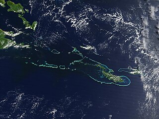
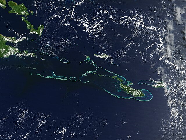
English: Off the southeast tip of Papua New Guinea lies a string of small volcanic islands and coral reefs collectively called the Louisiade Archipelago. This true-color MODIS image from September 11, 2002, is centered on the island chain, with Papua New Guinea at the left edge. Moving westward from eastern end of the chain are the islands of Rossel and Tagula. (Misima Island, which harbors the largest village in the region, is obscured by a patch of clouds northeast of image center.) To the north of the chain lies the Solomon Sea, and to the south is the Coral Sea. Most of the undisturbed land is covered by tropical rainforest, and despite their small size, the islands harbor a number of plant and animal species found nowhere else. |
| თარიღი | 7 მაისი 2005 (original upload date) |
| წყარო | Transferred from en.wikipedia |
| ავტორი | NASA |
ლიცენზია
| This file is in the public domain in the United States because it was solely created by NASA. NASA copyright policy states that "NASA material is not protected by copyright unless noted". (See Template:PD-USGov, NASA copyright policy page or JPL Image Use Policy.) | ||
 |
Warnings:
|
ატვირთვის ჟურნალი
All following user names refer to en.wikipedia.
- 2005-05-07 02:55 PDH 2000×1500× (459961 bytes) Off the southeast tip of Papua New Guinea lies a string of small volcanic islands and coral reefs collectively called the Louisiade Archipelago. This true-color MODIS image from September 11, 2002, is centered on the island chain, with Papua New Guinea at
ფაილის ისტორია
დააწკაპუნეთ თარიღზე/დროზე ფაილის დასათვალიერებლად, როგორც ის მაშინ გამოიყურებოდა.
| თარიღი/დრო | მინიატიურა | ზომები | მომხმარებელი | შენიშვნა | |
|---|---|---|---|---|---|
| მიმდინარე | 08:55, 18 ოქტომბერი 2009 | | 2 000×1 500 (449 კბ) | Urdangaray | {{Information |Description={{en|Off the southeast tip of Papua New Guinea lies a string of small volcanic islands and coral reefs collectively called the Louisiade Archipelago. This true-color MODIS image from September 11, 2002, is centered on the island |
ბმულები
ამ ფაილზე ბმული მოცემულია შემდეგ გვერდებზე:
ფაილის გლობალური გამოყენება
ეს ფაილი გამოიყენება შემდეგ ვიკებში:
- გამოყენება als.wikipedia.org-ში
- გამოყენება ast.wikipedia.org-ში
- გამოყენება br.wikipedia.org-ში
- გამოყენება ca.wikipedia.org-ში
- გამოყენება ceb.wikipedia.org-ში
- გამოყენება de.wikipedia.org-ში
- გამოყენება en.wikipedia.org-ში
- გამოყენება en.wikivoyage.org-ში
- გამოყენება eo.wikipedia.org-ში
- გამოყენება es.wikipedia.org-ში
- გამოყენება eu.wikipedia.org-ში
- გამოყენება he.wikivoyage.org-ში
- გამოყენება hy.wikipedia.org-ში
- გამოყენება it.wikipedia.org-ში
- გამოყენება la.wikipedia.org-ში
- გამოყენება or.wikipedia.org-ში
- გამოყენება pl.wikipedia.org-ში
- გამოყენება vi.wikipedia.org-ში
- გამოყენება www.wikidata.org-ში