
ფაილი:Spanish Empire.png
თავდაპირველი ფაილი ((1 357 × 628 პიქსელი, ფაილის ზომა: 38 კბ, MIME ტიპი: image/png))
| ეს ფაილი მდებარეობს Wikimedia Commons სერვერზე. იხილეთ მისი აღწერის გვერდი სრული ინფორმაციისთვის. |
 |
გადასვლა ფაილის გვერდზე |

== რეზიუმე == sijn is kaulo koel en voeg zijn snap ( stijnsnoeck12)
| აღწერა |
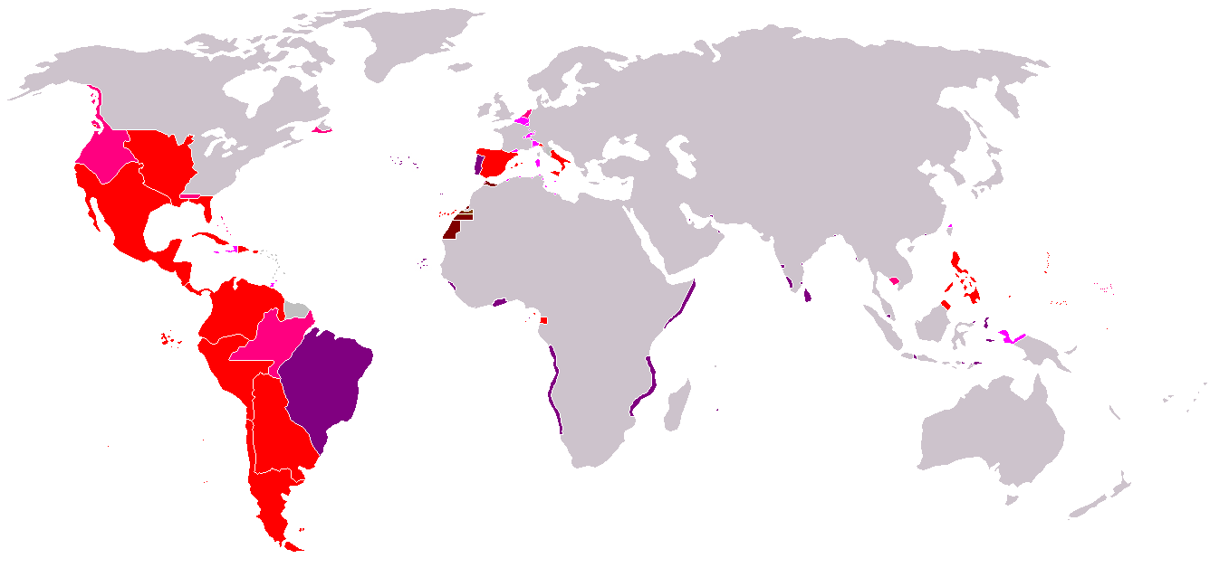
Map of the Spanish Empire from 295px. რეზიუმეRedThe Spanish Empire as it stood under the en:House of Bourbon, reaching its peak in the early 1790s. Includes the en:Viceroyalty of New Spain, en:Viceroyalty of Peru, en:Viceroyalty of La Plata, en:Viceroyalty of New Granada, en:Audiencia of Chile, en:Cuba, en:Puerto Rico, en:Santo Domingo, the Louisiana colony, the Nootka colony, the en:Philippines, the satellite en:Kingdom of Naples and en:Duchy of Parma, and various island groups. Louisiana and New Orleans, which were never widely settled, were returned to France in 1800, the Nootka colony was abandoned in 1795; Spain ceded its claims to the en:Mississippi Territory to the United States in 1795 and en:Florida in 1819; en:New Spain became an independent en:Mexico in 1821. Spanish settlement did not reach the south of Argentina and Chile until the early en:19th century. By 1824, all of Spain's South American colonies had become independent republics. British economic rights in present-day en:Belize were established in the 18th century. The colony of en:British Honduras was not created until 1841, after the end of Spanish rule in the region. Most of Central America became independent in 1823 as the en:United Provinces of Central America. Cuba was granted independence and Puerto Rico was ceded to the United States after the en:Spanish-American War. PinkRegions of Spanish influence over various periods; disputed (i.e. Pacific Coast), unrecognized (i.e. en:Dutch Republic), or short-lived claims (i.e. Cambodia).
LavenderTerritories lost at or before the en:Peace of Utrecht in 1714. Spain lost Jamaica to England in the 1650s and Haiti to France in the en:17th century. Many smaller islands in the en:Bahamas and the en:Lesser Antilles were also settled by other Europeans during this period. Spain's territories in present-day France, such as en:Rousillon and the en:Franche-Comté, were conquered Louis XIV. Spain was stripped of her remaining European dominions in 1714. Spain reconquered some of her lost Italian possessions from the Austrians in the 18th century, placing Bourbon princes on the thrones of Parma, Naples, and Sicily. However, these were not incorporated again into the Spanish Crown. PurplePortuguese possessions ruled jointly under the Spanish sovereign, 1580-1640. BrownSpain's en:West African empire, including en:Spanish West Africa and en:Spanish Morocco. |
| თარიღი | Commons upload by Kjetil r 10:47, 14 May 2006 (UTC) |
| წყარო |
Originally from en.wikipedia; description page is (was) here
|
| ავტორი | Users Albrecht, Arthur Wellesley, XGustaX on en.wikipedia |
| უფლება (ფაილის მეორეული გამოყენება) |
GFDL |
ლიცენზია

|
თქვენ შეგიძიათ გაავრცელოთ ან შეცვალოთ დოკუმენტი GNU Free Documentation ლიცენზიის 1.2 ან უფრო გვიანდელი ვერსიის პირობების თანახმად, რომელიც გამოქვეყნებულია თავისუფალი პროგრამული უზრუნველყოფის ფონდის მიერ, შეუცვლელი განყოფილებების გარეშე, პირველ და ბოლო გვერდებზე განთავსებულ ტექსტებზე. ლიცენზიის ასლი არის განთავსებული განყოფილებაში სახელად GNU Free Documentation License. |
| ეს ნამუშევარი ვრცელდება Creative Commons Attribution-Share Alike 3.0 Unported ლიცენზიით. | ||
| ||
| ეს ლიცენზირების ნიშანი დაემატა ამ ფაილს, როგორც GFDL ლიცენზიის განახლების ნაწილი. |
See also


ფაილის ისტორია
დააწკაპუნეთ თარიღზე/დროზე ფაილის დასათვალიერებლად, როგორც ის მაშინ გამოიყურებოდა.
| თარიღი/დრო | მინიატიურა | ზომები | მომხმარებელი | შენიშვნა | |
|---|---|---|---|---|---|
| მიმდინარე | 19:37, 18 აპრილი 2008 | | 1 357×628 (38 კბ) | Durero | Reverted to version as of 18:01, 16 April 2008 Talk |
| 18:58, 18 აპრილი 2008 |  | 1 357×628 (37 კბ) | Patstuart | Reverted to version as of 01:45, 15 April 2008 - Portugal was never part of the Spanish empire | |
| 18:01, 16 აპრილი 2008 |  | 1 357×628 (38 კბ) | Durero | Reverted to version as of 20:27, 14 January 2008 | |
| 01:45, 15 აპრილი 2008 |  | 1 357×628 (37 კბ) | The Ogre | Correcting erros - the Portuguese empire was never a part of the Spanish empire | |
| 20:27, 14 იანვარი 2008 |  | 1 357×628 (38 კბ) | Durero | I include Sabah | |
| 09:19, 28 სექტემბერი 2006 |  | 1 357×628 (38 კბ) | Koika | The Spanish area in Taiwan is ony NOT correct. | |
| 10:48, 14 მაისი 2006 |  | 1 357×628 (38 კბ) | Kjetil r | ||
| 20:12, 11 მაისი 2006 |  | 1 357×628 (38 კბ) | Kjetil r | {{Information| |Description= == Summary == Map of the en:Spanish Empire from Image:BlankMap-World.png. ==Description== *Red: all claimed Spanish territories(1492-1975), shown together simultaneously and at their maximum extent. Actual contol and set |
ბმულები
ამ ფაილზე ბმული მოცემულია შემდეგ გვერდებზე:
ფაილის გლობალური გამოყენება
ეს ფაილი გამოიყენება შემდეგ ვიკებში:
- გამოყენება an.wikipedia.org-ში
- გამოყენება ar.wikipedia.org-ში
- გამოყენება ast.wikipedia.org-ში
- გამოყენება cs.wikipedia.org-ში
- გამოყენება da.wikipedia.org-ში
- გამოყენება en.wikipedia.org-ში
- გამოყენება es.wikipedia.org-ში
- გამოყენება fr.wikipedia.org-ში
- გამოყენება gl.wikipedia.org-ში
- გამოყენება it.wikipedia.org-ში
- გამოყენება sv.wikipedia.org-ში
- გამოყენება th.wikipedia.org-ში
- გამოყენება zh.wikipedia.org-ში