
ფაილი:Boundary Stone (District of Columbia) SE 9.tiff

უფრო მაღალი გარჩევადობა არ არის შესაძლებელი.
Boundary_Stone_(District_of_Columbia)_SE_9.tiff ((368 × 411 პიქსელი, ფაილის ზომა: 188 კბ, MIME ტიპი: image/tiff))
| ეს ფაილი მდებარეობს Wikimedia Commons სერვერზე. იხილეთ მისი აღწერის გვერდი სრული ინფორმაციისთვის. |
 |
გადასვლა ფაილის გვერდზე |
|
This is an image of a place or building that is listed on the National Register of Historic Places in the United States of America. Its reference number is 96001242. |
რეზიუმე
| აღწერა |
English: Boundary stone SE 9 marking the borders of the District of Columbia. This is one of 40 original stones, the one furthest south in the current district. In 1907 it was essentially IN the Potomac River |
| თარიღი | |
| წყარო | http://www.boundarystones.org/read.php?page=rchs_1907/84b |
| ავტორი | Woodward, Fred E.: "A Ramble Along the Boundary Stones of the District of Columbia With a Camera," Records of the Columbia Historical Society, Vol. 10, pp. 63-87 (1907). |
| ობიექტის მდებარეობა | | იხილეთ ეს და სხვა ახლომდებარე სურათები საიტ(ებ)ზე OpenStreetMap |
|---|
ლიცენზია
This media file is in the public domain in the United States. This applies to U.S. works where the copyright has expired, often because its first publication occurred prior to January 1, 1929, and if not then due to lack of notice or renewal. See this page for further explanation.
|
 | |
 |
This image might not be in the public domain outside of the United States; this especially applies in the countries and areas that do not apply the rule of the shorter term for US works, such as Canada, Mainland China (not Hong Kong or Macao), Germany, Mexico, and Switzerland. The creator and year of publication are essential information and must be provided. See Wikipedia:Public domain and Wikipedia:Copyrights for more details.
|
ფაილის ისტორია
დააწკაპუნეთ თარიღზე/დროზე ფაილის დასათვალიერებლად, როგორც ის მაშინ გამოიყურებოდა.
| თარიღი/დრო | მინიატიურა | ზომები | მომხმარებელი | შენიშვნა | |
|---|---|---|---|---|---|
| მიმდინარე | 03:25, 29 მარტი 2012 | 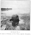 | 368×411 (188 კბ) | Smallbones |
ბმულები
ეს ფაილი არცერთ გვერდზე არ გამოიყენება.
ფაილის გლობალური გამოყენება
ეს ფაილი გამოიყენება შემდეგ ვიკებში: