
ფაილი:Yemen division 2011-7-7.svg

ამ SVG ფაილის PNG წინასწარი გადახედვის ზომაა: 800 × 522 პიქსელი. სხვა გაფართოება: 320 × 209 პიქსელი | 640 × 418 პიქსელი | 1 024 × 669 პიქსელი | 1 280 × 836 პიქსელი | 2 560 × 1 671 პიქსელი | 1 524 × 995 პიქსელი.
თავდაპირველი ფაილი (ფაილი SVG, ნომინალურად 1 524 × 995 პიქსელი, ფაილის ზომა: 1,05 მბ)
| ეს ფაილი მდებარეობს Wikimedia Commons სერვერზე. იხილეთ მისი აღწერის გვერდი სრული ინფორმაციისთვის. |
 |
გადასვლა ფაილის გვერდზე |
რეზიუმე
| აღწერა |
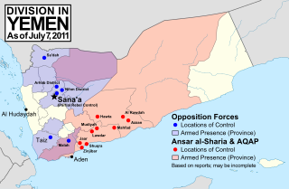
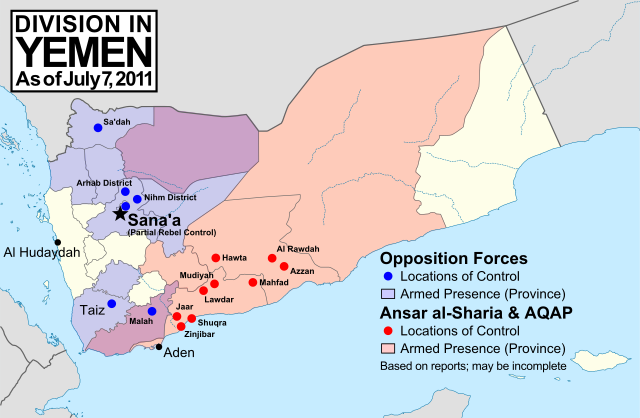
English: Note: This map depicts the situation in July 2011. For updated versions, see File:Yemen division 2011-10-23.svg and File:Yemen division 2012-3-11.svg. Map of division in Yemen as of July 7, 2011. Map is limited to information from from English-language media, and therefore may be incomplete. Red represents Islamist extremists under Ansar al-Sharia and/or Al-Qaeda in the Arabian Peninsula (AQAP). Blue represents all other non-government armed groups which are hostile or possibly hostile to the government of President Ali Abdullah Saleh, including military defectors, pre-existing rebel groups, and local and kinship-based militias. Dots indicate specific locations cited by the media as being currently controlled by said groups, while shading indicates provinces (governorates) from which an open armed presence or attacks by said groups have been reported since the uprising began (up until July 7, 2011). Purple shading indicates that Ansar al-Sharia/AQAP and other non-government forces both have armed presences reported within the province, while white indicates that no rebel activity has been reported (implying that Saleh's government still fully maintains state power there). Note that unarmed protests are not depicted, and would extend well into the white areas of the map. |
| თარიღი | |
| წყარო | პირადი ნამუშევარი, starting from File:Yemen_location_map.svg by user NordNordWest. Information comes from a variety of online news sources, especially the Yemen Post and Critical Threats. |
| ავტორი | GeoEvan |
| უფლება (ფაილის მეორეული გამოყენება) |
Modified version of file from Political Geography Now blog, re-licensed here to allow for commercial use. Please credit "Political Geography Now" with link to http://www.polgeonow.com. |
ლიცენზია
მე, ამ ნამუშევარზე საავტორო უფლებების მფლობელი, ვაქვეყნებ მას შემდეგი ლიცენზიით:
ეს ნამუშევარი ვრცელდება Creative Commons Attribution-Share Alike 3.0 Unported ლიცენზიით.
- თქვენ თავისუფლად შეგიძლიათ:
- ნამუშევრის გაზიარება – ნამუშევრის კოპირება, გავრცელება და გადაცემა.
- შექმნათ დაფუძნებულები – ნამუშევრის შესწორება
- შემდეგი პირობებით:
- მოხსენიება – თქვენ უნდა მიუთითოთ წყაროს შემქმნელი იმ გზით, რომელიც დანიშნა ავტორმა ან საავტორო უფლებების მფლობელმა. მაგრამ არა ისე, თითქოს წყაროს ავტორი მხარს გიჭერთ თქვენ ან დაუჭირა თქვენს მიერ შექმნილ ნაწარმოებს.
- გავრცელება იგივე პირობებეით – თუ თქვენ ცვლით, ან ქმნით ახალ ნაშრომს ამ ნამუშევრის გამოყენებთ, თქვენ გაქვთ უფლება გაავრცელოთ იგი იგივე ან შესაბამისი ლიცენზიით, რომლითაც ვრცელდება წყარო.
ფაილის ისტორია
დააწკაპუნეთ თარიღზე/დროზე ფაილის დასათვალიერებლად, როგორც ის მაშინ გამოიყურებოდა.
| თარიღი/დრო | მინიატიურა | ზომები | მომხმარებელი | შენიშვნა | |
|---|---|---|---|---|---|
| მიმდინარე | 15:02, 19 ნოემბერი 2011 | | 1 524×995 (1,05 მბ) | GeoEvan | Corrections per [http://en.wikipedia.org/wiki/File_talk:Yemen_division_2011-10-23.svg English Wikipedia talk page]: Added Sa'dah city to opposition controlled locations; changed "Islamist Militants" label to "Ansar a-Sharia & AQAP" so as to exclude the un |
| 09:20, 28 ოქტომბერი 2011 |  | 1 524×995 (1,02 მბ) | GeoEvan | =={{int:filedesc}}== {{Information |description={{en|1=''Note: This map depicts the situation in July 2011. For a more recent version, see File:Yemen division 2011-10-23.svg.'' Map of division in Yemen as of July 7, 2011. Map is limited to informatio |
ბმულები
ამ ფაილზე ბმული მოცემულია შემდეგ გვერდებზე:
ფაილის გლობალური გამოყენება
ეს ფაილი გამოიყენება შემდეგ ვიკებში:
- გამოყენება ar.wikipedia.org-ში
- გამოყენება en.wikipedia.org-ში
- გამოყენება hy.wikipedia.org-ში
- გამოყენება ru.wikipedia.org-ში