
ფაილი:SanFranCity2.jpg
თავდაპირველი ფაილი ((1 043 × 831 პიქსელი, ფაილის ზომა: 187 კბ, MIME ტიპი: image/jpeg))
| ეს ფაილი მდებარეობს Wikimedia Commons სერვერზე. იხილეთ მისი აღწერის გვერდი სრული ინფორმაციისთვის. |
 |
გადასვლა ფაილის გვერდზე |
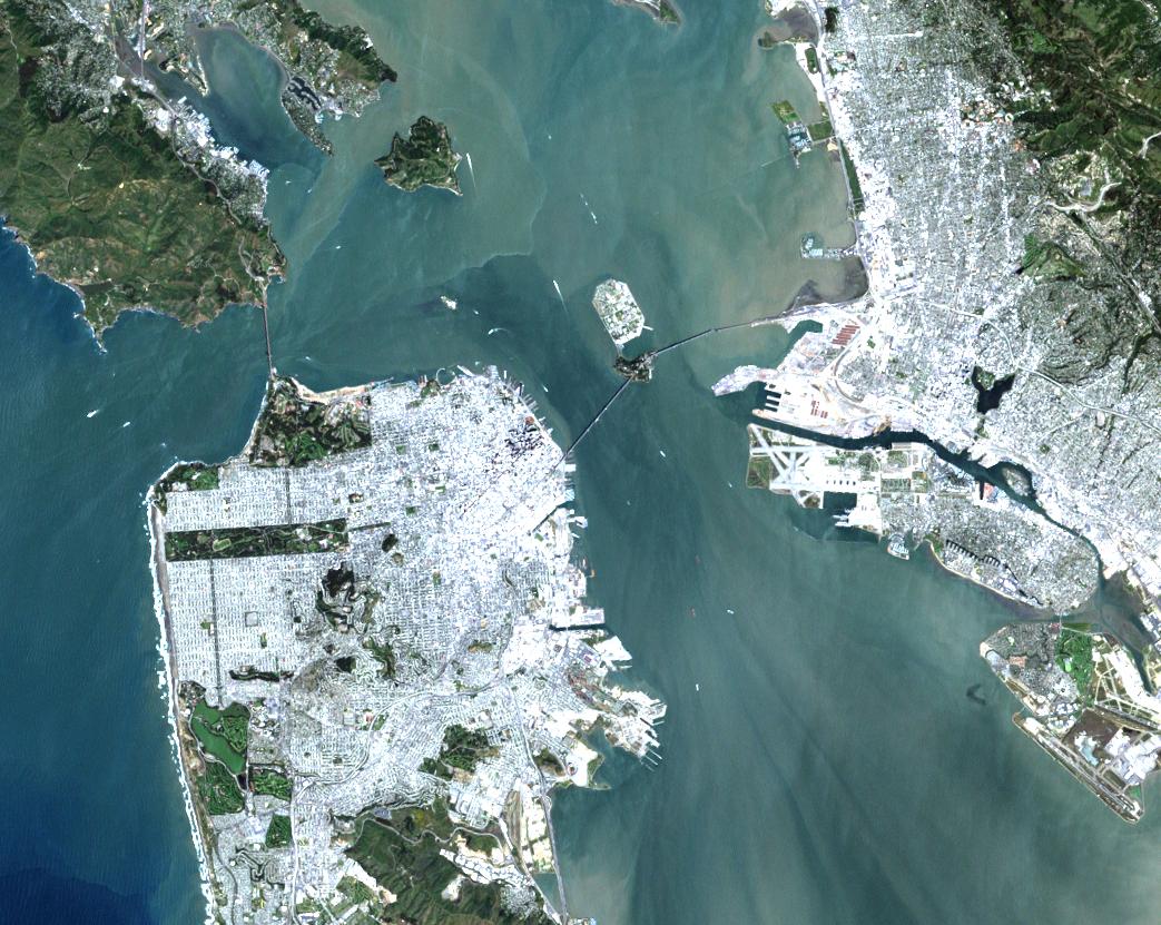
URL: http://visibleearth.nasa.gov/view_rec.php?id=133
Credit: Image courtesy EROS Data Center
On a rare fog free day Landsat 7 flew over San Francisco and produced this stunning true color image. You can easily see both man made structures—the Golden Gate Bridge, the Bay Bridge, Alcatraz, and Oakland International Airport—and natural features such as the Marin Headlands and the complex currents in San Francisco Bay.
This image was provided by the EROS Data Center Landsat 7 Data Handling Facility Image Assessment System (IAS). Landsat 7 digital data are not yet available to the general public. Browse, Level 0R and Level 1 data will be made available for retail sale this summer via the EROS Data Center following completion of orbit raising and instrument checkout and calibration.
| This file is in the public domain in the United States because it was solely created by NASA. NASA copyright policy states that "NASA material is not protected by copyright unless noted". (See Template:PD-USGov, NASA copyright policy page or JPL Image Use Policy.) | ||
 |
Warnings:
|
ფაილის ისტორია
დააწკაპუნეთ თარიღზე/დროზე ფაილის დასათვალიერებლად, როგორც ის მაშინ გამოიყურებოდა.
| თარიღი/დრო | მინიატიურა | ზომები | მომხმარებელი | შენიშვნა | |
|---|---|---|---|---|---|
| მიმდინარე | 20:28, 25 აგვისტო 2005 | | 1 043×831 (187 კბ) | Nanosmile | URL: http://visibleearth.nasa.gov/view_rec.php?id=133 Credit: Image courtesy EROS Data Center On a rare fog free day Landsat 7 flew over San Francisco and produced this stunning true color image. You can easily see both man made structures—the Golden |
ბმულები
ამ ფაილზე ბმული მოცემულია შემდეგ გვერდებზე:
ფაილის გლობალური გამოყენება
ეს ფაილი გამოიყენება შემდეგ ვიკებში:
- გამოყენება fr.wikipedia.org-ში
- გამოყენება ro.wikipedia.org-ში
- გამოყენება ru.wikipedia.org-ში