
ფაილი:Niuatoputapu tafahi tonga.jpg

ზომა წინასწარი გადახედვისას: 342 × 599 პიქსელი. სხვა გაფართოება: 137 × 240 პიქსელი | 274 × 480 პიქსელი | 644 × 1 127 პიქსელი.
თავდაპირველი ფაილი ((644 × 1 127 პიქსელი, ფაილის ზომა: 131 კბ, MIME ტიპი: image/jpeg))
| ეს ფაილი მდებარეობს Wikimedia Commons სერვერზე. იხილეთ მისი აღწერის გვერდი სრული ინფორმაციისთვის. |
 |
გადასვლა ფაილის გვერდზე |
რეზიუმე
| აღწერა |
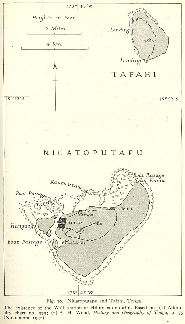
English: Niuatoputapu and Tafahi, Niua Islands, northern Tonga, Pacific Ocean |
| თარიღი | 1932, 1945 |
| წყარო | map is linked from this page, direct link from "Pacific Islands", Geographical Handbook Series, Great Britain. Admiralty. Naval Intelligence Division, 1943-1945. The map is based on two other sources as indicated below the map in the graphics file. |
| ავტორი | Admiralty. Naval Intelligence Division |
ლიცენზია
This file is in the public domain because it has been taken from a collection of public domain maps at the University of Texas Library- see http://www.lib.utexas.edu/usage_statement.html?maps=yes:
"Most of the maps scanned by the University of Texas Libraries and served from this web site are in the public domain. No permissions are needed to copy them. You may download them and use them as you wish. A few maps are copyrighted, and are clearly marked as such."
|
This work created by the United Kingdom Government is in the public domain.
This is because it is one of the following:
HMSO has declared that the expiry of Crown Copyrights applies worldwide (ref: HMSO Email Reply)
|
 |
ფაილის ისტორია
დააწკაპუნეთ თარიღზე/დროზე ფაილის დასათვალიერებლად, როგორც ის მაშინ გამოიყურებოდა.
| თარიღი/დრო | მინიატიურა | ზომები | მომხმარებელი | შენიშვნა | |
|---|---|---|---|---|---|
| მიმდინარე | 12:55, 25 ივნისი 2010 | | 644×1 127 (131 კბ) | Ratzer | {{Information |Description={{en|1=Niuatoputapu and Tafahi, Niua Islands, northern Tonga, Pacific Ocean}} |Source=http://www.lib.utexas.edu/maps/historical/pacific_islands_1943_1945/niuatoputapu_tafahi_tonga.jpg |Author=unknown |Date=1932 |Permission= |oth |
ბმულები
ამ ფაილზე ბმული მოცემულია შემდეგ გვერდებზე:
ფაილის გლობალური გამოყენება
ეს ფაილი გამოიყენება შემდეგ ვიკებში:
- გამოყენება de.wikipedia.org-ში
- გამოყენება ru.wikipedia.org-ში
- გამოყენება to.wikipedia.org-ში
- გამოყენება zh.wikipedia.org-ში