
ფაილი:Mare Tranquillitatis map.jpg
უფრო მაღალი გარჩევადობა არ არის შესაძლებელი.
Mare_Tranquillitatis_map.jpg ((343 × 344 პიქსელი, ფაილის ზომა: 69 კბ, MIME ტიპი: image/jpeg))
| ეს ფაილი მდებარეობს Wikimedia Commons სერვერზე. იხილეთ მისი აღწერის გვერდი სრული ინფორმაციისთვის. |
 |
გადასვლა ფაილის გვერდზე |
რეზიუმე
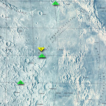
Map of Mare Tranquillitatis, cropped from http://www.jpl.nasa.gov/history/60s/Surveyor7_1968.htm.
The colored arrows indicate the landing sites of Apollo 11, the first manned moon mission, Apollo 17, Apollo 16, and Surveyor 5. To the southeast is Mare Fecunditatis, to the northeast is Mare Crisium, and to the south is Mare Nectaris.
Secondary source: http://en.wikipedia.org/wiki/Image:Mare_Tranquillitatis_map.jpg
ლიცენზია
| This file is in the public domain in the United States because it was solely created by NASA. NASA copyright policy states that "NASA material is not protected by copyright unless noted". (See Template:PD-USGov, NASA copyright policy page or JPL Image Use Policy.) | ||
 |
Warnings:
|
ფაილის ისტორია
დააწკაპუნეთ თარიღზე/დროზე ფაილის დასათვალიერებლად, როგორც ის მაშინ გამოიყურებოდა.
| თარიღი/დრო | მინიატიურა | ზომები | მომხმარებელი | შენიშვნა | |
|---|---|---|---|---|---|
| მიმდინარე | 23:00, 25 აგვისტო 2005 | | 343×344 (69 კბ) | Mattes | new |
ბმულები
ამ ფაილზე ბმული მოცემულია შემდეგ გვერდებზე:
ფაილის გლობალური გამოყენება
ეს ფაილი გამოიყენება შემდეგ ვიკებში:
- გამოყენება af.wikipedia.org-ში
- გამოყენება bg.wikipedia.org-ში
- გამოყენება cs.wikipedia.org-ში
- გამოყენება da.wikipedia.org-ში
- გამოყენება de.wikipedia.org-ში
- გამოყენება en.wikipedia.org-ში
- გამოყენება es.wikipedia.org-ში
- გამოყენება fa.wikipedia.org-ში
- გამოყენება fi.wikipedia.org-ში
- გამოყენება fr.wikipedia.org-ში
- გამოყენება he.wikipedia.org-ში
- გამოყენება id.wikipedia.org-ში
- გამოყენება it.wikipedia.org-ში
- გამოყენება ko.wikipedia.org-ში
- გამოყენება lb.wikipedia.org-ში
- გამოყენება nl.wikipedia.org-ში
- გამოყენება pl.wikipedia.org-ში
- გამოყენება pt.wikipedia.org-ში
- გამოყენება ro.wikipedia.org-ში
- გამოყენება ru.wikipedia.org-ში
- გამოყენება simple.wikipedia.org-ში
- გამოყენება sv.wikipedia.org-ში
- გამოყენება zh.wikipedia.org-ში