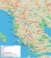
ფაილი:Map of ancient Epirus and environs (English).svg

გვერდი სხვა ენებზე არ არის ხელმისაწვდომი.
მასალა ვიკიპედიიდან — თავისუფალი ენციკლოპედია

თავდაპირველი ფაილი(ფაილი SVG, ნომინალურად 1 303 × 1 500 პიქსელი, ფაილის ზომა: 495 კბ)

ეს ფაილი მდებარეობს Wikimedia Commons სერვერზე.
იხილეთ მისი აღწერის გვერდი სრული ინფორმაციისთვის.
გადასვლა ფაილის გვერდზე
Translate this file

ეს SVG ფაილი იყენებს თანდართულ ტექსტს, რომელიც ადვილად შეიძლება ითარგმნოს თქვენს ენაზე using [toolforge:svgtranslate/File:Map_of_ancient_Epirus_and_environs_(English).svglink this automated tool]. გაიგეთ მეტი. You can also download it and translate it manually using a text editor.

რეზიუმე

აღწერა
English: Map of ancient Epirus & Environs, Thracian, Illyrian, Paeonian, & Greek contact zones with illustration and extent of Hellenization up to the creation of Epirus Nova or Illyria Graeca
თარიღი
წყარო პირადი ნამუშევარი
ავტორი MaryroseB54
სხვა ვერსიები

[რედაქტირება]

  • The classical age of Greece (1999),
  • ed. Atlas of the Greek and Roman world in antiquity (1981).
  • Hammond, N. G. L. A History of Greece to 322 B.C., 1986, ISBN-10: 0198730950
  • Wilkes, J. J. The Illyrians, 1992,ISBN 0631198075, (i.e. pages 174, 208, 210, 273)
  • In the Shadow of Olympus: The Emergence of Macedon,ISBN 0691008809,1992
  • Thracian Tribal areas (from Fol, Thrace and the Thracians, p 133),The Thracians 700 BC–AD 46 (Men-at-Arms 360) by Christopher Webber After Hoddinot, Col & Cah
  • Hendry, p. 299. The geography is entirely correct for Servius' time, since Diocletian's rearrangement of provincial boundaries included the creation of the province of Epirus Nova out of southern Illyricum with Dyrrachium (=Epidamnus) as its capital.
  • The Loeb Editor's Notes, 28 Nova Epirus or Illyris Graeca (Epirus, Nova Illyria Graeca) "Nova Epirus or Illyris Graeca extended from the Drilo (Mod. Drina) River on the north to the Ceraunian Mts. on the south, thus comprising a large part of modern Albania. Immediately to the south of it to the Ambracian Gulf (Mod. Gulf of Arta) lay what is here called Old Epirus, approximately identical with the Epirus of modern Greece."
  • Soustal, Peter; Koder, Johannes (1981). Tabula Imperii Byzantini, Band 3: Nikopolis und Kephallenia (in German). Vienna: Verlag der Osterreichischen Akademie der Wissenschaften. ISBN 3-7001-0399-9., page 47
  • A new classical dictionary of Greek and Roman biography, mythology, and geography: partly based upon the Dictionary of Greek and Roman biography and mythology by Sir William Smith,1851,page 392 "B. Illyris Graeca, which was called in later times Epirus Nova, extended from the river Drilo to the SE., up to the Ceraunian mountains, which separated it from Epirus Proper"
  • American journal of philology, Τόμοι 98-99,by JSTOR (Organization), Project Muse,1977,page 263, the partly Hellenic and partly Hellenized Epirus Nova
  • Epirus Vetus: The Archaeology of a Late Antique Province (Duckworth Archaeology) by William Bowden,2003,ISBN-10: 0715631160,2003,page 233,of Lissos in Epirus Nova
  • Migrations and invasions in Greece and adjacent areas by Nicholas Geoffrey Lempriere Hammond,1976,ISBN -0815550472,page 54,The line of division between Illyricum and the Greek area Epirus nova
  • Athanassakis, A.N. (1977), "N.G.L. Hammond, Migrations and Invasions in Greece and Adjacent Areas (review)", American Journal of Philology 99: 263–6, JSTOR 293653
  • Hammond, N. G. L. A History of Greece to 322 B.C., 1986, ISBN-10: 0198730950
  • Triadafilopoulos, Triadafilos (November 2000). "Power politics and nationalist discourse in the struggle for 'Northern Epirus': 1919-1921". Journal of Southern Europe and the Balkans,
  • Encyclopedia Britannica,2002,ISBN -0852297874,The Roman province of Illyricum stretched from the Drilon River (the Drin, in modern Albania) in the south to Istria (modem Slovenia and Croatia)
  • History of the Byzantine Empire: Vol. 1, 324-1453 (Paperback) by Alexander A. Vasiliev
  • Epire, Illyrie, Macedoine: melanges offerts au professeur Pierre Cabanes by Daniele Berranger,Pierre Cabanes,Daniele Berranger-Auserve,page 130
  • In An Inventory of Archaic and Classical Poleis by Mogens Herman, ISBN 0-19-814099-1, 2004, i.e. "As a long-distance trading community, Aigina was not an active coloniser, but colonised Kydonia (no. 968) in 519, Adria (no. 75) c.C61, and Damastion in Illyria after 431 (Strabo 8.6.16)." & page 348
  • The Cambridge Ancient History: The Hellenistic monarchies and the rise of Rome, 1964. page 836 "of mixed barbarian and Greek population, such as Dimale (or Dimallum), of unknown"
  • The Illyrian Atintani, the Epirotic Atintanes and the Roman Protectorate N. G. L. Hammond, The Journal of Roman Studies Vol. 79 (1989), pp. 11-25 "There were Illyrian Amantini in Pannonia and Greek Amantes in North Epirus"
  • Blank map from Image:Map greek sanctuaries-fr.svg (The empty map used is not topographic, nor does it offer the capacity of gps precision, but its easy on the eyes and aesthetically pleasing in general)

ლიცენზია

მე, ამ ნამუშევარზე საავტორო უფლებების მფლობელი, ვაქვეყნებ მას შემდეგი ლიცენზიით:
w:ka:Creative Commons
მოხსენიება გავრცელება იგივე პირობებეით
This file is licensed under the Creative Commons Attribution-Share Alike 4.0 International license.
თქვენ თავისუფლად შეგიძლიათ:
  • ნამუშევრის გაზიარება – ნამუშევრის კოპირება, გავრცელება და გადაცემა.
  • შექმნათ დაფუძნებულები – ნამუშევრის შესწორება
შემდეგი პირობებით:
  • მოხსენიება – თქვენ უნდა მიუთითოთ წყაროს შემქმნელი იმ გზით, რომელიც დანიშნა ავტორმა ან საავტორო უფლებების მფლობელმა. მაგრამ არა ისე, თითქოს წყაროს ავტორი მხარს გიჭერთ თქვენ ან დაუჭირა თქვენს მიერ შექმნილ ნაწარმოებს.
  • გავრცელება იგივე პირობებეით – თუ თქვენ ცვლით, ან ქმნით ახალ ნაშრომს ამ ნამუშევრის გამოყენებთ, თქვენ გაქვთ უფლება გაავრცელოთ იგი იგივე ან შესაბამისი ლიცენზიით, რომლითაც ვრცელდება წყარო.
Annotations
InfoField
This image is annotated: View the annotations at Commons

Captions

Add a one-line explanation of what this file represents

source of file ინგლისური

original creation by uploader ინგლისური

MIME type ინგლისური

image/svg+xml

ფაილის ისტორია

დააწკაპუნეთ თარიღზე/დროზე ფაილის დასათვალიერებლად, როგორც ის მაშინ გამოიყურებოდა.

თარიღი/დრომინიატიურაზომებიმომხმარებელიშენიშვნა
მიმდინარე04:38, 22 ნოემბერი 2021მინიატურა 04:38, 22 ნოემბერი 2021 ვერსიისთვის1 303×1 500 (495 კბ)KhirurgMeant to upload this version
04:22, 22 ნოემბერი 2021მინიატურა 04:22, 22 ნოემბერი 2021 ვერსიისთვის1 303×1 500 (495 კბ)KhirurgMade some corrections
01:36, 28 დეკემბერი 2020მინიატურა 01:36, 28 დეკემბერი 2020 ვერსიისთვის1 303×1 500 (493 კბ)CastellFile uploaded using svgtranslate tool (https://svgtranslate.toolforge.org/). Added translation for ca.
01:26, 28 დეკემბერი 2020მინიატურა 01:26, 28 დეკემბერი 2020 ვერსიისთვის1 303×1 500 (492 კბ)CastellFile uploaded using svgtranslate tool (https://svgtranslate.toolforge.org/). Added translation for ca.
11:15, 24 ივნისი 2016მინიატურა 11:15, 24 ივნისი 2016 ვერსიისთვის1 303×1 500 (383 კბ)MaryroseB54Parthos
23:58, 22 ივნისი 2016მინიატურა 23:58, 22 ივნისი 2016 ვერსიისთვის1 303×1 500 (382 კბ)MaryroseB54as per source
22:52, 22 ივნისი 2016მინიატურა 22:52, 22 ივნისი 2016 ვერსიისთვის1 303×1 500 (382 კბ)MaryroseB54Position
21:07, 22 ივნისი 2016მინიატურა 21:07, 22 ივნისი 2016 ვერსიისთვის1 303×1 500 (382 კბ)MaryroseB54Position fix
10:06, 20 ივნისი 2016მინიატურა 10:06, 20 ივნისი 2016 ვერსიისთვის1 303×1 500 (382 კბ)MaryroseB54User created page with UploadWizard

ამ ფაილზე ბმული მოცემულია შემდეგ გვერდებზე:

ფაილის გლობალური გამოყენება

ეს ფაილი გამოიყენება შემდეგ ვიკებში:

იხილეთ, ამ ფაილის გლობალური გამოყენება.

მეტამონაცემები