
ფაილი:BNR (Ruthienie Blanche) Map 1918.jpg

თავდაპირველი ფაილი ((4 400 × 3 015 პიქსელი, ფაილის ზომა: 10,27 მბ, MIME ტიპი: image/jpeg))
| ეს ფაილი მდებარეობს Wikimedia Commons სერვერზე. იხილეთ მისი აღწერის გვერდი სრული ინფორმაციისთვის. |
_Map_1918.jpg?uselang=ka) |
გადასვლა ფაილის გვერდზე |
_Map_1918.jpg)
რეზიუმე
| სათაური |
Беларуская: Карта Беларускай Народнай Рэспублікі, 1918 Беларуская (тарашкевіца): Мапа Беларускай Народнай Рэспублікі, 1918
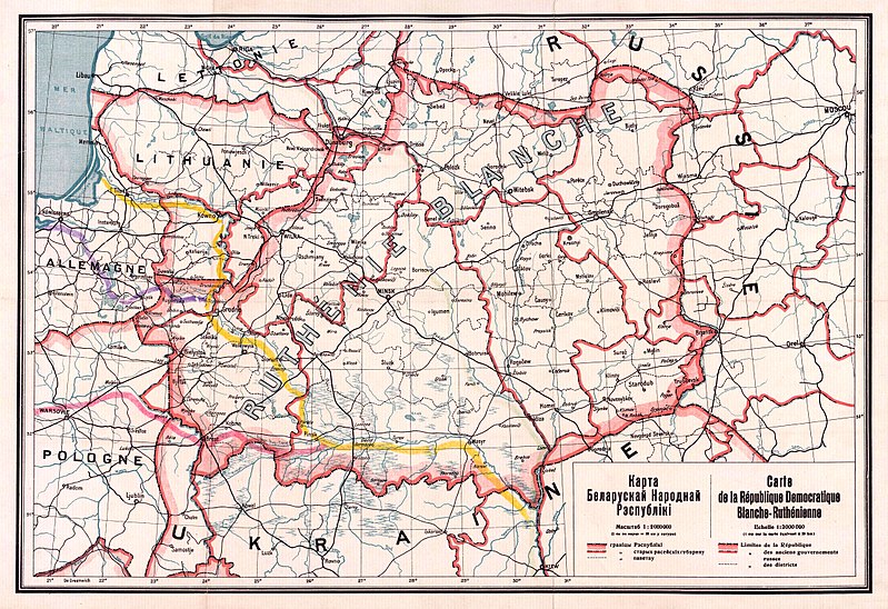
English: Map of the territory claimed by the Belarusian People's Republic (published in 1918).
Русский: Карта Белорусской Народной Республики, 1918
Українська: Карта Білоруської Народної Республіки, 1918 |
| თარიღი | |
| წყარო |
1. Карта БНР 1918 год, IMAGO.BY 2. Originally uploaded to English Wikipedia by Rydel (21:53, 2 January 2005) as en:Image:BNR ruthienie blanche.jpg. |
| შემქმნელი |
უცნობი |
| Georeferencing | If inappropriate please set warp_status = skip to hide. |
ლიცენზია
|
This work is in the public domain in its country of origin and other countries and areas where the copyright term is the author's life plus 70 years or fewer.
| |
| This file has been identified as being free of known restrictions under copyright law, including all related and neighboring rights. | |
ფაილის ისტორია
დააწკაპუნეთ თარიღზე/დროზე ფაილის დასათვალიერებლად, როგორც ის მაშინ გამოიყურებოდა.
| თარიღი/დრო | მინიატიურა | ზომები | მომხმარებელი | შენიშვნა | |
|---|---|---|---|---|---|
| მიმდინარე | 13:56, 26 ოქტომბერი 2017 | | 4 400×3 015 (10,27 მბ) | Kazimier Lachnovič | better quality |
| 14:18, 3 სექტემბერი 2005 |  | 1 000×700 (195 კბ) | EugeneZelenko | Map of Belarusian National Republic (published in 1918). Originally uploaded to English Wikipedia by Rydel (21:53, 2 January 2005) as en:Image:BNR ruthienie blanche.jpg. Category:Historical maps of Belarus |
ბმულები
ეს ფაილი არცერთ გვერდზე არ გამოიყენება.
ფაილის გლობალური გამოყენება
ეს ფაილი გამოიყენება შემდეგ ვიკებში:
- გამოყენება ar.wikipedia.org-ში
- გამოყენება ast.wikipedia.org-ში
- გამოყენება be-tarask.wikipedia.org-ში
- გამოყენება be.wikipedia.org-ში
- გამოყენება bg.wikipedia.org-ში
- გამოყენება ca.wikipedia.org-ში
- გამოყენება cs.wikipedia.org-ში
- გამოყენება cy.wikipedia.org-ში
- გამოყენება da.wikipedia.org-ში
- გამოყენება de.wikipedia.org-ში
- გამოყენება en.wikipedia.org-ში
- გამოყენება eo.wikipedia.org-ში
- გამოყენება es.wikipedia.org-ში
- გამოყენება et.wikipedia.org-ში
- გამოყენება eu.wikipedia.org-ში
- გამოყენება fr.wikipedia.org-ში
იხილეთ, ამ ფაილის გლობალური გამოყენება.
_Map_1918.jpg)
_Map_1918.jpg)