
ფაილი:Puerto Rico departamentos 1886.jpg

ზომა წინასწარი გადახედვისას: 800 × 531 პიქსელი. სხვა გაფართოება: 320 × 212 პიქსელი | 640 × 425 პიქსელი | 1 024 × 680 პიქსელი | 1 280 × 850 პიქსელი | 2 250 × 1 494 პიქსელი.
თავდაპირველი ფაილი ((2 250 × 1 494 პიქსელი, ფაილის ზომა: 1,44 მბ, MIME ტიპი: image/jpeg))
| ეს ფაილი მდებარეობს Wikimedia Commons სერვერზე. იხილეთ მისი აღწერის გვერდი სრული ინფორმაციისთვის. |
 |
გადასვლა ფაილის გვერდზე |

|
This file has been superseded by Mapa topográfico de la isla de Puerto Rico. LOC 98687140 (retocada).jpg. It is recommended to use the other file. Please note that deleting superseded images requires consent.
|
.jpg)
|
რეზიუმე
| აღწერა |
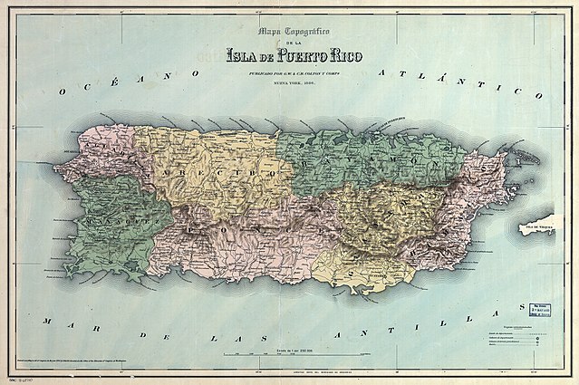
English: Map of Puerto Rico with Spanish colonial administrative subdivisions into departamentos — 1886. |
| თარიღი | |
| წყარო | http://robertospuertorico.com/wp-content/uploads/2010/10/PR-Topo-1886-with-regions-in-color-225.jpg |
| ავტორი | G.W. & C.B. Colton & Co. |
ლიცენზია
|
This work is in the public domain in its country of origin and other countries and areas where the copyright term is the author's life plus 100 years or fewer. This work is in the public domain in the United States because it was published (or registered with the U.S. Copyright Office) before January 1, 1929. | |
| This file has been identified as being free of known restrictions under copyright law, including all related and neighboring rights. | |
ფაილის ისტორია
დააწკაპუნეთ თარიღზე/დროზე ფაილის დასათვალიერებლად, როგორც ის მაშინ გამოიყურებოდა.
| თარიღი/დრო | მინიატიურა | ზომები | მომხმარებელი | შენიშვნა | |
|---|---|---|---|---|---|
| მიმდინარე | 09:37, 21 ივნისი 2018 | | 2 250×1 494 (1,44 მბ) | Ratzer | Reverted to version as of 20:27, 11 February 2011 (UTC) - new policy seems to be to keep such marks, as to identify unique prints |
| 07:25, 12 სექტემბერი 2015 |  | 2 250×1 494 (2,31 მბ) | Hic et nunc | stamp removed by [https://de.wikipedia.org/w/index.php?title=Wikipedia%3AFotowerkstatt&type=revision&diff=145949796&oldid=145944730 request of the uploader] | |
| 20:27, 11 თებერვალი 2011 |  | 2 250×1 494 (1,44 მბ) | Ratzer | {{Information |Description ={{en|1=map of Puerto Rico with administrative subdivision into departamentos 1886}} |Source =http://robertospuertorico.com/wp-content/uploads/2010/10/PR-Topo-1886-with-regions-in-color-225.jpg |Author =? |Dat |
ბმულები
ამ ფაილზე ბმული მოცემულია შემდეგ გვერდებზე:
ფაილის გლობალური გამოყენება
ეს ფაილი გამოიყენება შემდეგ ვიკებში:
- გამოყენება ar.wikipedia.org-ში
- გამოყენება azb.wikipedia.org-ში
- გამოყენება de.wikipedia.org-ში
- გამოყენება en.wikipedia.org-ში
- გამოყენება es.wikipedia.org-ში
- გამოყენება fr.wikipedia.org-ში
- გამოყენება pt.wikipedia.org-ში