
ფაილი:Parked boats at Anjarle Creek.jpg

თავდაპირველი ფაილი ((4 094 × 2 428 პიქსელი, ფაილის ზომა: 5,97 მბ, MIME ტიპი: image/jpeg))
| ეს ფაილი მდებარეობს Wikimedia Commons სერვერზე. იხილეთ მისი აღწერის გვერდი სრული ინფორმაციისთვის. |
 |
გადასვლა ფაილის გვერდზე |
რეზიუმე
| აღწერა |
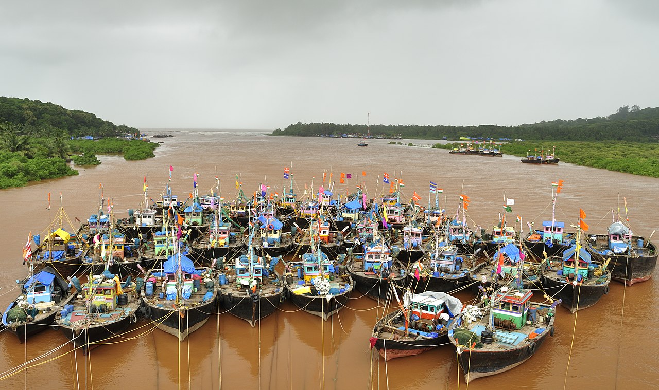
English: Anjarle is a village in the Konkan region of Maharashtra, India. The villages in this region depend a lot on fishing and transporting goods. There are some developed fish markets around here, where trade happens during the day.
In the monsoon seasons, fishermen are often not able to to go to the sea. The photograph shows a number of boats parked in a creek near Anjarle village. At the distance one can see the sea and impending rain. The primary objective of this photograph was to capture the rustic feel. Deutsch: Boote in Anjarle, Indien |
| თარიღი | |
| წყარო | პირადი ნამუშევარი |
| ავტორი | Dey.sandip |
| უფლება (ფაილის მეორეული გამოყენება) |
Sandip Dey, ამ ნამუშევარზე საავტორო უფლებების მფლობელი, ვაქვეყნებ მას შემდეგი ლიცენზიით: ეს ფაილი ვრცელდება Creative Commons Attribution 3.0 Unported ლიცენზიით. ავტორის მითითება: Sandip Dey
|
| კამერის მდებარეობა | | იხილეთ ეს და სხვა ახლომდებარე სურათები საიტ(ებ)ზე OpenStreetMap |
|---|
Assessment
|
This image was selected as picture of the day on Bengali Wikipedia.
|
This image was selected as picture of the day on Wikimedia Commons for 12 December 2012. It was captioned as follows: Other languages:
Bahasa Melayu: Bot yang diletakkan di anak sungai Anjarle (Konkan), Maharashtra, India. Magyar: A monszun idejére kikötött halászhajók az Anjarle patakon a hasonnevű falu mellett India Mahárástra államának Konkan megyéjében. A kép hátterében egy esőfront közelít a tenger felett. Nederlands: Geparkeerde boten bij Anjarle Creek (Konkan) in de staat Maharashtra in India. Русский: Суда на якоре, Конкан, Махараштра, Индия 中文: 季风季节停泊在印度马哈拉施特拉邦安杰尔河口的渔船。 |
This image was selected as picture of the day on Vietnamese Wikipedia.
|
ფაილის ისტორია
დააწკაპუნეთ თარიღზე/დროზე ფაილის დასათვალიერებლად, როგორც ის მაშინ გამოიყურებოდა.
| თარიღი/დრო | მინიატიურა | ზომები | მომხმარებელი | შენიშვნა | |
|---|---|---|---|---|---|
| მიმდინარე | 20:53, 14 ნოემბერი 2012 | | 4 094×2 428 (5,97 მბ) | Dey.sandip | CA fixed. Some horizon fixing again. |
| 07:46, 14 ნოემბერი 2012 |  | 4 094×2 428 (6,11 მბ) | Dey.sandip | Crop from top to align with 1/3 rd, slight tilt fixing | |
| 15:54, 11 ნოემბერი 2012 |  | 4 144×2 635 (5,71 მბ) | Dey.sandip | User created page with UploadWizard |
ბმულები
ამ ფაილზე ბმული მოცემულია შემდეგ გვერდებზე:
ფაილის გლობალური გამოყენება
ეს ფაილი გამოიყენება შემდეგ ვიკებში:
- გამოყენება ar.wikipedia.org-ში
- გამოყენება azb.wikipedia.org-ში
- გამოყენება be-tarask.wikipedia.org-ში
- გამოყენება bh.wikipedia.org-ში
- გამოყენება bn.wikipedia.org-ში
- გამოყენება ceb.wikipedia.org-ში
- გამოყენება crh.wikipedia.org-ში
- გამოყენება cv.wikipedia.org-ში
- გამოყენება en.wikipedia.org-ში
- India
- Climate of India
- Market sentiment
- Fishing vessel
- Anjarle
- Wikipedia:WikiProject Ships/Showcase
- Wikipedia:WikiProject India/Recognized content
- Wikipedia:WikiProject India/Main page featured content
- Wikipedia:Featured pictures/Vehicles/Water
- User talk:Dey.sandip
- Fishery Survey of India
- Wikipedia:WikiProject Fisheries and Fishing/Recognized content
- Talk:India/Archive 47
- Wikipedia:Featured pictures thumbs/68
- Wikipedia:Featured picture candidates/September-2020
- Wikipedia:Featured picture candidates/Parked boats at Anjarle Creek
- Wikipedia:Wikipedia Signpost/2020-09-27/Featured content
- Wikipedia:Wikipedia Signpost/Single/2020-09-27
- Talk:India/Archive 49
- Portal:India/Recognized content
- Wikipedia:Picture of the day/March 2023
- Template:POTD/2023-03-11
- Wikipedia:Main Page history/2023 March 11
- Wikipedia:Main Page history/2023 March 11b
- გამოყენება fa.wikipedia.org-ში
- გამოყენება hi.wikipedia.org-ში
- გამოყენება hu.wikipedia.org-ში
- გამოყენება hy.wikipedia.org-ში
- გამოყენება it.wikipedia.org-ში
- გამოყენება kk.wikipedia.org-ში
- გამოყენება ko.wikipedia.org-ში
- გამოყენება krc.wikipedia.org-ში
- გამოყენება lbe.wikipedia.org-ში
- გამოყენება lt.wikipedia.org-ში
- გამოყენება os.wikipedia.org-ში
- გამოყენება pt.wikipedia.org-ში
იხილეთ, ამ ფაილის გლობალური გამოყენება.