
ფაილი:Noord-Holland position.svg

ამ SVG ფაილის PNG წინასწარი გადახედვის ზომაა: 200 × 236 პიქსელი. სხვა გაფართოება: 203 × 240 პიქსელი | 407 × 480 პიქსელი | 651 × 768 პიქსელი | 868 × 1 024 პიქსელი | 1 736 × 2 048 პიქსელი.
თავდაპირველი ფაილი (ფაილი SVG, ნომინალურად 200 × 236 პიქსელი, ფაილის ზომა: 158 კბ)
| ეს ფაილი მდებარეობს Wikimedia Commons სერვერზე. იხილეთ მისი აღწერის გვერდი სრული ინფორმაციისთვის. |
 |
გადასვლა ფაილის გვერდზე |
რეზიუმე
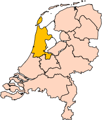
| აღწერა | Location of the province of Noord-Holland (North Holland) in the Netherlands. |
| თარიღი | |
| წყარო | Own work, based on freely available GIS data |
| ავტორი | User:Mtcv |
| უფლება (ფაილის მეორეული გამოყენება) |
Data: attribution required; my work: PD |
| სხვა ვერსიები | I attempted to make an svg version of Image:Noord Holland-Position.png (with less simplified boundaries) |
Clickable version

ლიცენზია

|
ამ ნამუშევრის მფლობელი, Centraal Bureau voor de Statistiek, ნებას აძლევს ყველას გამოიყენოს იგი ნებისმიერი მიზნით იმ პირობით, თუ მფლობელი მოხსენიებული იქნება. ნამუშევრის გავრცელება, გადაცემა და კომერციული გამოყენება დაშვებულია. |
ავტორის მითითება:
|
| Annotations | This image is annotated: View the annotations at Commons |


ფაილის ისტორია
დააწკაპუნეთ თარიღზე/დროზე ფაილის დასათვალიერებლად, როგორც ის მაშინ გამოიყურებოდა.
| თარიღი/დრო | მინიატიურა | ზომები | მომხმარებელი | შენიშვნა | |
|---|---|---|---|---|---|
| მიმდინარე | 17:20, 2 მარტი 2019 | | 200×236 (158 კბ) | Thayts | update |
| 15:13, 2 ოქტომბერი 2006 |  | 200×236 (158 კბ) | Mtcv | {{Information| |Description=Location of the province of Noord-Holland (North Holland) in the Netherlands. |Source=Own work, based on freely available GIS data |Date=2006-10-02 |Author=User:Mtcv |Permission=Data: attribution required; my work: PD |othe |
ბმულები
ეს ფაილი არცერთ გვერდზე არ გამოიყენება.
ფაილის გლობალური გამოყენება
ეს ფაილი გამოიყენება შემდეგ ვიკებში:
- გამოყენება ar.wikipedia.org-ში
- أمستردام
- شمال-هولندا
- هلفرسوم
- ألكمار
- هارلم (شمال-هولندا)
- زانستاد
- هارلمرمير
- قالب:بلديات شمال هولندا
- سخاخن
- دن هيلدر
- فيلسن
- زانتفورت
- بلوميندال
- ألسمير
- لاندسمير
- أوستزان
- تيسل
- أمستلفين
- إنكهاوزن
- هورن (هولندا)
- فاترلاند
- بيمستر
- بيفيرفايك
- بيرخن (شمال هولندا)
- بلاريكوم
- هيمستيده
- بوابة:أمستردام/قوالب
- بوابة:أمستردام
- حكومة أمستردام
- هارلمرليده آن سبارنفاودا
- آودر- أمستل
- ديمين
- فيسب (هولندا)
- كاستركوم
- دريخترلاند
- إدام- فولندام
- هيمسكيرك
- هيرهوخوفارد
- هيلو (هولندا)
- هولاندز كرون
- هاوزن
- كوخينلاند
- لانجادايك
- لارين (هولندا)
- ميديمبليك
- أوبمير
- بورميراند
- ستيده بروك
- آوتخيست
- آوتهورن
იხილეთ, ამ ფაილის გლობალური გამოყენება.