
ფაილი:Location map Peninsula Malaysia.png

თავდაპირველი ფაილი ((539 × 656 პიქსელი, ფაილის ზომა: 449 კბ, MIME ტიპი: image/png))
| ეს ფაილი მდებარეობს Wikimedia Commons სერვერზე. იხილეთ მისი აღწერის გვერდი სრული ინფორმაციისთვის. |
 |
გადასვლა ფაილის გვერდზე |

|
უცნობი ტიპის «locator map» ეს გამოსახულება უნდა იყოს გადახატული .svg ფორმატში. ყოველივე ეს გვაძლევს რამდენიმე მოგებას, რის შესახებაც შეგიძლიათ წაიკითხოთ Commons:Media for cleanup. თუ თქვენ უკვე გაქვთ .svg ვერსია, ძალიან გთხოვთ ატვირთოთ იგი. ატვირთვის შემდეგ გთხოვთ შეცვალოთ ეს თარგი შემდეგით - {{Vector version available|ფაილის სახელი.svg}}.
|
რეზიუმე
| აღწერა |
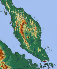
Relief map of Peninsula Malaysia Geographic limits of the map:
|
| თარიღი | |
| წყარო | http://www.maps-for-free.com/ |
| ავტორი | Modified by Dr. Blofeld |
| უფლება (ფაილის მეორეული გამოყენება) |
http://www.maps-for-free.com/html/about.html |
ლიცენზია
This screenshot either does not contain copyright-eligible parts or visuals of copyrighted software, or the author has released it under a free license (which should be indicated beneath this notice), and as such follows the licensing guidelines for screenshots of Wikimedia Commons. You may use it freely according to its particular license. Free software license:

|
ეს ნამუშევარი არის თავისუფალი პროგრამული უზრუნველყოფა; თქვენ შეგიძლიათ გაავრცელოთ იგი GNU General Public ლიცენზიის თანახმად, პირობების გამოქვეყნებულია თავისუფალი პროგრამული უზრუნველყოფის ფონდის მიერ; ვერსია 2 ან უფრო გვიანდელი. ეს ნამუშევარი ვრცელდება იმ იმედით, რომ იგი იქნება საჭირო, მაგრამ გარანტიის გარეშე, მათ შორის merchantability ან fitness for a particular purpose გარანტიების გარეშე. დამატებით იხ. ვერსია 2 და და ვერსია 3 GNU General Public ლიცენზიის პირობები. |
Note: if the screenshot shows any work that is not a direct result of the program code itself, such as a text or graphics that are not part of the program, the license for that work must be indicated separately.
ლიცენზია
- თქვენ თავისუფლად შეგიძლიათ:
- ნამუშევრის გაზიარება – ნამუშევრის კოპირება, გავრცელება და გადაცემა.
- შექმნათ დაფუძნებულები – ნამუშევრის შესწორება
- შემდეგი პირობებით:
- მოხსენიება – თქვენ უნდა მიუთითოთ წყაროს შემქმნელი იმ გზით, რომელიც დანიშნა ავტორმა ან საავტორო უფლებების მფლობელმა. მაგრამ არა ისე, თითქოს წყაროს ავტორი მხარს გიჭერთ თქვენ ან დაუჭირა თქვენს მიერ შექმნილ ნაწარმოებს.
ფაილის ისტორია
დააწკაპუნეთ თარიღზე/დროზე ფაილის დასათვალიერებლად, როგორც ის მაშინ გამოიყურებოდა.
| თარიღი/დრო | მინიატიურა | ზომები | მომხმარებელი | შენიშვნა | |
|---|---|---|---|---|---|
| მიმდინარე | 11:58, 6 მარტი 2011 | | 539×656 (449 კბ) | Blofeld Dr. | {{Information |Description ={{en|1=y}} |Source =y |Author =y |Date =y |Permission = |other_versions = }} |
ბმულები
ამ ფაილზე ბმული მოცემულია შემდეგ გვერდებზე:
ფაილის გლობალური გამოყენება
ეს ფაილი გამოიყენება შემდეგ ვიკებში:
- გამოყენება bg.wikipedia.org-ში
- გამოყენება bn.wikipedia.org-ში
- გამოყენება da.wikipedia.org-ში
- გამოყენება el.wikipedia.org-ში
- გამოყენება en.wikipedia.org-ში
- გამოყენება es.wikipedia.org-ში
- გამოყენება fa.wikipedia.org-ში
- გამოყენება fi.wikipedia.org-ში
- გამოყენება haw.wikipedia.org-ში
- გამოყენება id.wikipedia.org-ში
- გამოყენება it.wikipedia.org-ში
- გამოყენება ja.wikipedia.org-ში
- გამოყენება jv.wikipedia.org-ში
- გამოყენება ko.wikipedia.org-ში
- გამოყენება pa.wikipedia.org-ში
- გამოყენება pl.wikipedia.org-ში
- გამოყენება sr.wikipedia.org-ში
- გამოყენება ta.wikipedia.org-ში
- გამოყენება th.wikipedia.org-ში
- გამოყენება uk.wikipedia.org-ში
- გამოყენება vep.wikipedia.org-ში
- გამოყენება zh-yue.wikipedia.org-ში
- გამოყენება zh.wikipedia.org-ში