
ფაილი:Karoo ecoregion.jpg
უფრო მაღალი გარჩევადობა არ არის შესაძლებელი.
Karoo_ecoregion.jpg ((644 × 496 პიქსელი, ფაილის ზომა: 114 კბ, MIME ტიპი: image/jpeg))
| ეს ფაილი მდებარეობს Wikimedia Commons სერვერზე. იხილეთ მისი აღწერის გვერდი სრული ინფორმაციისთვის. |
 |
გადასვლა ფაილის გვერდზე |
რეზიუმე
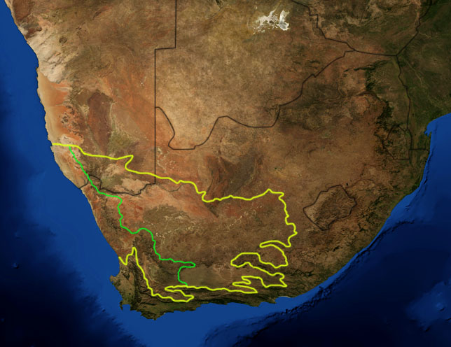
| აღწერა | This is a map showing the location of the two Karoo ecoregions of southern Africa, as delineated by the World Wide Fund for Nature. The yellow line encloses the two ecoregions. The green line separates the Succulent Karoo, on the west, from the Nama Karoo, on the east. National boundaries are shown in black. I, Pfly, made it using NASA Blue Marble imagery and ecoregion GIS data which I simplified and digitized in Photoshop. |
| თარიღი | |
| წყარო | NASA, plus my additions by myself. |
| ავტორი | Pfly |
ლიცენზია
| This file is in the public domain in the United States because it was solely created by NASA. NASA copyright policy states that "NASA material is not protected by copyright unless noted". (See Template:PD-USGov, NASA copyright policy page or JPL Image Use Policy.) | ||
 |
Warnings:
|
ფაილის ისტორია
დააწკაპუნეთ თარიღზე/დროზე ფაილის დასათვალიერებლად, როგორც ის მაშინ გამოიყურებოდა.
| თარიღი/დრო | მინიატიურა | ზომები | მომხმარებელი | შენიშვნა | |
|---|---|---|---|---|---|
| მიმდინარე | 20:29, 19 იანვარი 2007 | | 644×496 (114 კბ) | Pfly | {{Information |Description=This is a map showing the location of the two Karoo ecoregions of southern Africa, as delineated by the World Wide Fund for Nature. The yellow line encloses the two ecoregions. Th |
ბმულები
ამ ფაილზე ბმული მოცემულია შემდეგ გვერდებზე:
ფაილის გლობალური გამოყენება
ეს ფაილი გამოიყენება შემდეგ ვიკებში:
- გამოყენება af.wikipedia.org-ში
- გამოყენება bg.wikipedia.org-ში
- გამოყენება ca.wikipedia.org-ში
- გამოყენება de.wikipedia.org-ში
- გამოყენება en.wikipedia.org-ში
- გამოყენება eo.wikipedia.org-ში
- გამოყენება es.wikipedia.org-ში
- გამოყენება fi.wikipedia.org-ში
- გამოყენება frr.wikipedia.org-ში
- გამოყენება fr.wikipedia.org-ში
- გამოყენება fr.wiktionary.org-ში
- გამოყენება gl.wikipedia.org-ში
- გამოყენება hu.wikipedia.org-ში
- გამოყენება it.wikipedia.org-ში
- გამოყენება ja.wikipedia.org-ში
- გამოყენება ko.wikipedia.org-ში
- გამოყენება lt.wikipedia.org-ში
- გამოყენება nl.wikipedia.org-ში
- გამოყენება no.wikipedia.org-ში
- გამოყენება pt.wikipedia.org-ში
- გამოყენება ru.wikipedia.org-ში
- გამოყენება sv.wikipedia.org-ში
- გამოყენება sw.wikipedia.org-ში
- გამოყენება tr.wikipedia.org-ში