
ფაილი:Into the Jaws of Death 23-0455M edit.jpg

ზომა წინასწარი გადახედვისას: 745 × 600 პიქსელი. სხვა გაფართოება: 298 × 240 პიქსელი | 596 × 480 პიქსელი | 954 × 768 პიქსელი | 1 272 × 1 024 პიქსელი | 2 544 × 2 048 პიქსელი | 2 963 × 2 385 პიქსელი.
თავდაპირველი ფაილი ((2 963 × 2 385 პიქსელი, ფაილის ზომა: 3,53 მბ, MIME ტიპი: image/jpeg))
| ეს ფაილი მდებარეობს Wikimedia Commons სერვერზე. იხილეთ მისი აღწერის გვერდი სრული ინფორმაციისთვის. |
 |
გადასვლა ფაილის გვერდზე |
რეზიუმე
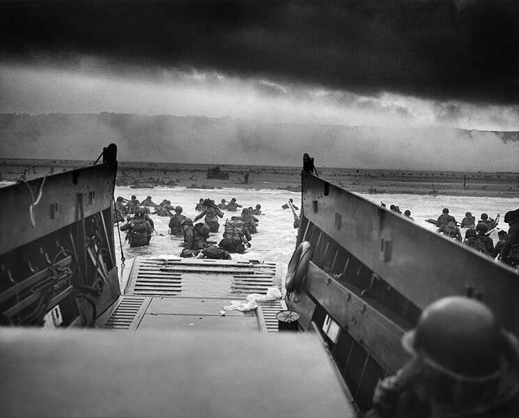
| Robert F. Sargent: Into the Jaws of Death
|
|||||||||||||||||||||||||||
|---|---|---|---|---|---|---|---|---|---|---|---|---|---|---|---|---|---|---|---|---|---|---|---|---|---|---|---|
| შემსრულებელი |
Chief Photographer's Mate (CPHoM) Robert F. Sargent |
 | |||||||||||||||||||||||||
| სათაური |
English: Second World War: Europe; "Into the Jaws of Death — U.S. Troops wading through water and Nazi gunfire”, circa 1944-06-06.
Deutsch: Zweiter Weltkrieg, Europa; "In den Rachen des Todes: US-Truppen-Wasserweg unter Nazi-Kugeln." Das Foto wurde am 6. Juni 1944 gegen 7:40 Uhr aufgenommen.
Español: Segunda Guerra Mundial, Europa. "Entre las fauces de la muerte: las tropas estadounidenses caminan por el agua bajo los proyectiles nazis". Foto tomada alrededor de las 07:40 de la mañana circa del 6 de junio de 1944.
Français : Seconde Guerre mondiale en Europe; « Into the Jaws of Death ». Des fantassins américains débarquent d'un Landing Craft Vehicle & Personnel sous le feu de l'armée allemande. Photo prise circa 6 juin 1944.
Italiano: Seconda guerra mondiale, Europa. "Tra le fauci della morte: le truppe statunitensi Waterwalk sotto i proiettili nazisti". Foto scattata intorno alle 7:40 del 6 giugno 1944. |
||||||||||||||||||||||||||
| ნაწილი |
Records of the U.S. Coast Guard (NAID 355) |
||||||||||||||||||||||||||
| Object type |
ფოტოგრაფია |
||||||||||||||||||||||||||
| ჟანრი |
war photography |
||||||||||||||||||||||||||
| აღწერა |
English: A LCVP (Landing Craft, Vehicle, Personnel) from the U.S. Coast Guard-manned USS Samuel Chase disembarks troops of Company A, 16th Infantry, 1st Infantry Division (the Big Red One) wading onto the Fox Green section of Omaha Beach (Calvados, Basse-Normandie, France) on the morning of June 6, 1944. American soldiers encountered the newly formed German 352nd Division when landing. During the initial landing two-thirds of Company E became casualties.
Español: Un LCVP (Lancha de Desembarco, Vehículo, Personal) del USS Samuel Chase, tripulado por la Guardia Costera de los EE. UU., desembarca tropas de la Compañía A, 16.° de Infantería, 1.° División de Infantería (la Roja Grande) vadeando hacia la sección Fox Green de la playa de Omaha (Calvados, Basse-Normandie, Francia) en la mañana del 6 de junio de 1944. Los soldados estadounidenses se encontraron con la recién formada 352.° División alemana al aterrizar. Durante el aterrizaje inicial, dos tercios de la Compañía E se convirtieron en bajas.
|
||||||||||||||||||||||||||
| თარიღი | 6 ივნისი 1944, 08:30 | ||||||||||||||||||||||||||
| კოლექციაში |
|
||||||||||||||||||||||||||
| ამჟამინდელი მდებარეობა |
|
||||||||||||||||||||||||||
| საინვენტარო ნომერი |
NAIL Control Number: NLR-PHOCO-A-7298 |
||||||||||||||||||||||||||
| Place of creation |
საფრანგეთი |
||||||||||||||||||||||||||
| შენიშვნები |
The coordinates are estimated values. For further reading see: www.famouspictures.org. Identification of the soldier via: The Free Lance-Star - June 6, 1984. See also a map of the Fox Green section at Omaha Beach. The following changes were applied to this restoration: global sharpness increased, filaments/dust/dirt removed, levels adjusted, cropped. |
||||||||||||||||||||||||||
| უფლებამოსილი კონტროლი | |||||||||||||||||||||||||||
| წყარო/ფოტოგრაფი |
|
||||||||||||||||||||||||||
| სხვა ვერსიები |
|
||||||||||||||||||||||||||
.jpg)
| კამერის მდებარეობა | | იხილეთ ეს და სხვა ახლომდებარე სურათები საიტ(ებ)ზე OpenStreetMap |
|---|
| Annotations | This image is annotated: View the annotations at Commons |
ლიცენზია
This image or file is a work of a United States Coast Guard service personnel or employee, taken or made as part of that person's official duties. As a work of the U.S. federal government, the image or file is in the public domain (17 U.S.C. § 101 and § 105, USCG main privacy policy and specific privacy policy for its imagery server).
|
 |
Assessment
|

This image was selected as picture of the day on Wikimedia Commons for 6 June 2012. It was captioned as follows: English: A LCVP from the U.S. Coast Guard-manned USS Samuel Chase disembarks troops of Company E, 16th Infantry, 1st Infantry Division wading onto Omaha Beach on the morning of June 6, 1944. American soldiers encountered the newly formed German 352nd Division when landing. During the initial landing two thirds of the Company E became casualties. Other languages:
Dansk: En LCVP landsætter amerikanske tropper fra USS Samuel Chase på Omaha Beach i Normandiet om morgenen 6. juni 1944. English: A LCVP from the U.S. Coast Guard-manned USS Samuel Chase disembarks troops of Company E, 16th Infantry, 1st Infantry Division wading onto Omaha Beach on the morning of June 6, 1944. American soldiers encountered the newly formed German 352nd Division when landing. During the initial landing two thirds of the Company E became casualties. Español: Un LCVP desde el USS Samuel Chase desembarca tropas de la Compañía E, 16.° de Infantería, 1.ª División vadeando en la Playa de Omaha la mañana del 6 de junio de 1944. Los soldados estadounidenses se encontraron la recién formada 352.ª División de Infantería alemana en tierra. Durante el primer desembarco dos tercios de la Compañía E fueron bajas. Français : Une barge de débarquement provenant de l'USS Samuel Chase pilotée par les garde-côtes des États-Unis débarque des troupes de la compagnie E de 1re division d'infanterie américaine, dans la matinée du 6 juin 1944 (le « Jour-J » de l'Opération Neptune) à Omaha Beach. Ces soldats affrontèrent la nouvellement formée 352e division d'infanterie de l'armée allemande. Durant le débarquement initial de cette compagnie, les deux tiers des soldats furent perdus. Italiano: 6 giugno 1944, un LCVP della USS Samuel Chase sbarca truppe della Compagnia E, 16º Fanteria, 1ª Divisione di fanteria sulla spiaggia di Omaha Beach. Durante le fasi iniziali dello sbarco la Compagnia E perderà due terzi degli effettivi. Nederlands: Een LCVP van het door de U.S. Coast Guard-bemannende USS Samuel Chase laadde troepen uit van Companie E, 16e infantriedivisie, 1e Infanteriedivisie wadend naar Omaha Beach in de ochtend van 6 juni 1944. Amerikaanse soldaten stootten tijdens de landing op de nieuw-gevormde Duitse 352e Infanteriedivisie. Македонски: Десантно пловило на бродот „Семјуел Чејс“ на Крајбрежната стража на САД како ја истоварува Четата Е на XVI пешадиски полк во походот наречен „Омаха Бич“ на 6 јуни 1944. По истоварувањето, четата се соочува со силната одбрана на новоформираната германска CCCLII дивизија, при што загинуваат две третини од војниците на четата. Русский: Десантный катер LCVP с корабля USS Samuel Chase высаживает войска на Омаха-Бич утром 6 июня 1944 года. ქართული: რობერტ სარჯენტის ფოტო „სიკვდილის ყბებში“, რომელიც, მეორე მსოფლიო ომის დროს, ამერიკელი ჯარისკაცების ნორმანდიაში გადასვლას ასახავს. |
ფაილის ისტორია
დააწკაპუნეთ თარიღზე/დროზე ფაილის დასათვალიერებლად, როგორც ის მაშინ გამოიყურებოდა.
| თარიღი/დრო | მინიატიურა | ზომები | მომხმარებელი | შენიშვნა | |
|---|---|---|---|---|---|
| მიმდინარე | 20:23, 19 ოქტომბერი 2011 | | 2 963×2 385 (3,53 მბ) | Christoph Braun | {{Artwork |artist=Chief Photographer's Mate (CPHoM) Robert F. Sargent |title=WWII: Europe: France; "Into the Jaws of Death - U.S. Troops wading through water and Nazi gunfire", ca. 06/06/1944 |description={{en|A LCVP |
ბმულები
ამ ფაილზე ბმული მოცემულია შემდეგ გვერდებზე:
ფაილის გლობალური გამოყენება
ეს ფაილი გამოიყენება შემდეგ ვიკებში:
- გამოყენება af.wikipedia.org-ში
- გამოყენება an.wikipedia.org-ში
- გამოყენება arc.wikipedia.org-ში
- გამოყენება ar.wikipedia.org-ში
- حلفاء الحرب العالمية الثانية
- إنزال النورماندي
- بوابة:الحرب العالمية الثانية/صورة مختارة/أرشيف
- صحافة مصورة
- اسم حركي
- ويكيبيديا:صور مختارة/تاريخ وأحداث/تاريخ عالمي
- التسلسل الزمني للحرب العالمية الثانية (1944)
- قائمة الصور الأيقونية
- في فكي الموت
- ويكيبيديا:ترشيحات الصور المختارة/إنزال النورماندي
- ويكيبيديا:صورة اليوم المختارة/مارس 2023
- قالب:صورة اليوم المختارة/2023-03-30
- بوابة:الحرب العالمية الثانية/صورة مختارة/18
- قالب:صورة اليوم المختارة/2024-04-25
- გამოყენება azb.wikipedia.org-ში
- გამოყენება az.wikipedia.org-ში
- გამოყენება az.wikiquote.org-ში
- გამოყენება be-tarask.wikipedia.org-ში
- გამოყენება be.wikipedia.org-ში
- გამოყენება bg.wikipedia.org-ში
- გამოყენება bh.wikipedia.org-ში
- გამოყენება bn.wikipedia.org-ში
- გამოყენება br.wikipedia.org-ში
- გამოყენება ca.wikipedia.org-ში
იხილეთ, ამ ფაილის გლობალური გამოყენება.