
ფაილი:Hong Kong Skyline Restitch - Dec 2007.jpg

ზომა წინასწარი გადახედვისას: 800 × 347 პიქსელი. სხვა გაფართოება: 320 × 139 პიქსელი | 640 × 278 პიქსელი | 1 024 × 444 პიქსელი | 1 280 × 555 პიქსელი | 4 250 × 1 844 პიქსელი.
თავდაპირველი ფაილი ((4 250 × 1 844 პიქსელი, ფაილის ზომა: 3,93 მბ, MIME ტიპი: image/jpeg))
| ეს ფაილი მდებარეობს Wikimedia Commons სერვერზე. იხილეთ მისი აღწერის გვერდი სრული ინფორმაციისთვის. |
 |
გადასვლა ფაილის გვერდზე |
რეზიუმე
| აღწერა |
Deutsch: Skyline von Hong Kong betrachtet vom Victoria Peak. Zusammengesetzt aus 78 Aufnahmen (26×3).
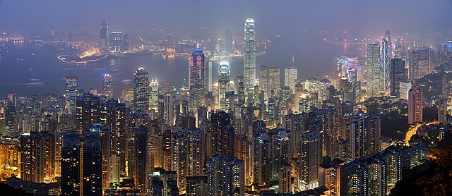
English: A 26 segment × 3 exposure (78 frames in total) panoramic view of the Hong Kong skyline taken from a path around Victoria Peak.
Français : Vue panoramique de Hong Kong depuis un sentier de Victoria Peak. Image construite en assemblant 78 clichés (26 visées × 3 expositions) réalisés avecun appareil Canon 5D et un objectif 85mm f/1.8 réglé sur f/5.6. |
| თარიღი | |
| წყარო | პირადი ნამუშევარი |
| ავტორი | Diliff |
| უფლება (ფაილის მეორეული გამოყენება) |
Summary:In using this image or any subsequent derivatives of it, you are required to release the image under the same license. As such, any reproduction of this image, in any medium, must appear with a copy of, or full URL of the license.Attribution of this image to the author (DAVID ILIFF) is also required, preferably in a prominent location near the image.No other conditions may be added to, or removed from this license without the permission of the author and copyright holder.Suggested attribution: "Photo by DAVID ILIFF. License: CC BY-SA 3.0"Please review the full license requirements carefully before using this image. If you would like to clarify the terms of the license or negotiate less restrictive commercial licensing outside of the bounds of GFDL/CC-BY-SA, please contact me by email, or if you don't have a Wikipedia account you can either leave a message on my talk page with your contact details and your request, or you can contact me on Facebook. Please also send a 'friend request' to ensure that I am aware of your message. |
| სხვა ვერსიები |
|

| კამერის მდებარეობა | | იხილეთ ეს და სხვა ახლომდებარე სურათები საიტ(ებ)ზე OpenStreetMap |
|---|
|
This image was selected as picture of the day on Wikimedia Commons for 6 July 2008. It was captioned as follows: English: Panoramic view of the Hong Kong skyline taken from a path around Victoria Peak Other languages:
Bosanski: Panoramski pogled na hongkoški horizont sa staze kod vrha Viktorija. English: Panoramic view of the Hong Kong skyline taken from a path around Victoria Peak Español: Vista panorámica del distrito central de Hong Kong desde la Cumbre Victoria. Français : Vue panoramique de Hong Kong depuis un sentier de Victoria Peak. Image construite en assemblant 78 clichés (26 visées × 3 expositions) réalisés avec un appareil Canon 5D et un objectif 85mm f/1.8 réglé sur f/5.6. Italiano: Vista di Hong Kong dal Victoria Peak, Cina. Magyar: Hongkongi panorámakép a Viktória-csúcsról nézve Nederlands: Panorama van het stedelijk silhouet van Hongkong, gezien vanaf een pad rond Victoria Peak, de hoogste berg van Hongkong Island Português: Vista panorâmica do distrito central de Hong Kong, feita dos arredores do pico Victoria. Suomi: Näkymä Hong Kongin yli läheiseltä Victoria Peak -vuorelta Беларуская: Панарама Ганконга з гары Вікторыя-Пік. Українська: Панорама Гонконгу з гори Вікторія (Victoria Peak) मराठी: हाँग काँग चे परिदृश्य 한국어: 홍콩 빅토리아 피크에서 바라본 야경. العربية : صورة بانورامية للأفق في هونج كونج. |
| Camera Model | Canon EOS 5D |
|---|---|
| Aperture | f/5.6 |
| Lens | 85 mm f/1.8 |
| Focal length | 85 mm |
ეს ფაილი იყო შეფასებული ხარისხიანი ფაილების სახელმძღვანელოს მეშვეობით და ითვლება ერთ-ერთ ხარისხიან ნამუშევრად.
|
ლიცენზია
მე, ამ ნაწარმოებზე საავტორო უფლებების მფლობელი, საკუთარი სურვილით ვაქვეყნებ მას შემდეგი ლიცენზიით:

|
თქვენ შეგიძიათ გაავრცელოთ ან შეცვალოთ დოკუმენტი GNU Free Documentation ლიცენზიის 1.2 ან უფრო გვიანდელი ვერსიის პირობების თანახმად, რომელიც გამოქვეყნებულია თავისუფალი პროგრამული უზრუნველყოფის ფონდის მიერ, შეუცვლელი განყოფილებების გარეშე, პირველ და ბოლო გვერდებზე განთავსებულ ტექსტებზე. ლიცენზიის ასლი არის განთავსებული განყოფილებაში სახელად GNU Free Documentation License. |
ეს ფაილი ვრცელდება Creative Commons Attribution 3.0 Unported ლიცენზიით.
- თქვენ თავისუფლად შეგიძლიათ:
- ნამუშევრის გაზიარება – ნამუშევრის კოპირება, გავრცელება და გადაცემა.
- შექმნათ დაფუძნებულები – ნამუშევრის შესწორება
- შემდეგი პირობებით:
- მოხსენიება – თქვენ უნდა მიუთითოთ წყაროს შემქმნელი იმ გზით, რომელიც დანიშნა ავტორმა ან საავტორო უფლებების მფლობელმა. მაგრამ არა ისე, თითქოს წყაროს ავტორი მხარს გიჭერთ თქვენ ან დაუჭირა თქვენს მიერ შექმნილ ნაწარმოებს.
თქვენ შეგიძლიათ აირჩიოთ ლიცენზია.
ფაილის ისტორია
დააწკაპუნეთ თარიღზე/დროზე ფაილის დასათვალიერებლად, როგორც ის მაშინ გამოიყურებოდა.
| თარიღი/დრო | მინიატიურა | ზომები | მომხმარებელი | შენიშვნა | |
|---|---|---|---|---|---|
| მიმდინარე | 21:55, 29 აპრილი 2008 | | 4 250×1 844 (3,93 მბ) | Diliff | == Summary == {{Information |Description={{en|A 26 segment x 3 exposure (78 frames in total) panoramic view of the Hong Kong skyline taken from a path around Victoria Peak. Taken by myself with a Canon 5D and 85mm f/1.8 lens at f/5.6.}} {{de|Skyline von H |
ბმულები
ამ ფაილზე ბმული მოცემულია შემდეგ გვერდებზე:
ფაილის გლობალური გამოყენება
ეს ფაილი გამოიყენება შემდეგ ვიკებში:
- გამოყენება ace.wikipedia.org-ში
- გამოყენება af.wikipedia.org-ში
- გამოყენება arc.wikipedia.org-ში
- გამოყენება ar.wikipedia.org-ში
- გამოყენება arz.wikipedia.org-ში
- გამოყენება as.wikipedia.org-ში
- გამოყენება azb.wikipedia.org-ში
- გამოყენება bn.wikipedia.org-ში
- გამოყენება bxr.wikipedia.org-ში
- გამოყენება ca.wikipedia.org-ში
- გამოყენება ceb.wikipedia.org-ში
- გამოყენება crh.wikipedia.org-ში
- გამოყენება cs.wikipedia.org-ში
- გამოყენება cv.wikipedia.org-ში
- გამოყენება da.wikipedia.org-ში
- გამოყენება de.wikipedia.org-ში
- გამოყენება diq.wikipedia.org-ში
- გამოყენება dv.wikipedia.org-ში
- გამოყენება el.wikipedia.org-ში
- გამოყენება en.wikipedia.org-ში
- User:Diliff
- Portal:Politics/Featured content
- Wikipedia:WikiProject Urban studies and planning
- Portal:China/Selected article and pictures
- Wikipedia:WikiProject Countries/Assessment
- Portal:Capitalism/Selected article
- Portal:Capitalism/Selected article/1
- Wikipedia:Featured pictures/Places/Panorama
- Wikipedia:WikiProject China/Featured and good content
- Portal:China/Selected picture
- Portal:Architecture/Townscape images
იხილეთ, ამ ფაილის გლობალური გამოყენება.