
ფაილი:CIRCASSIA1840.jpg
თავდაპირველი ფაილი ((6 348 × 3 047 პიქსელი, ფაილის ზომა: 544 კბ, MIME ტიპი: image/jpeg))
| ეს ფაილი მდებარეობს Wikimedia Commons სერვერზე. იხილეთ მისი აღწერის გვერდი სრული ინფორმაციისთვის. |
 |
გადასვლა ფაილის გვერდზე |
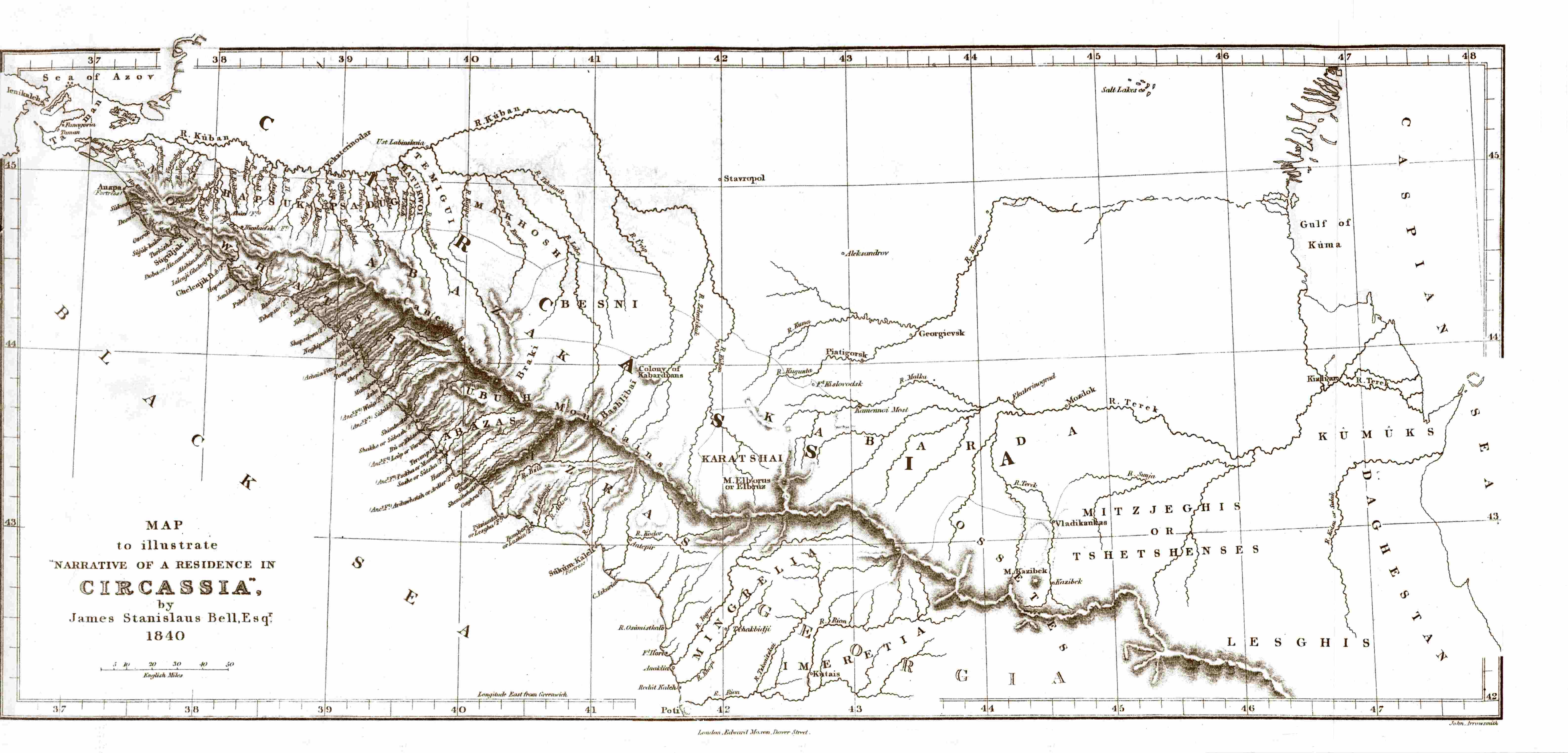
| აღწერა | Map of Circassia, made in 1840 during the en:Russian-Circassian War, PD due to author's death over 100 years ago. Found here, lon. 36.5° - 48° E, lat. 42° - 45.5° N | ||||
| თარიღი | 5 მაისი 2007 (original upload date) | ||||
| წყარო | Transferred from en.wikipedia to Commons. | ||||
| ავტორი |
James Stanislaus Bell (1797-1858) |
||||
| უფლება (ფაილის მეორეული გამოყენება) |
|
||||
ატვირთვის ჟურნალი
- 2007-05-05 20:44 SGGH 6348×3047×8 (556561 bytes) Map of Circassia, made in 1840 during the [[Russian-Circassian War]], PD due to author's death over 100 years ago. Found [http://www.circassianworld.com/CIRCASSIA1840.jpg here]
ფაილის ისტორია
დააწკაპუნეთ თარიღზე/დროზე ფაილის დასათვალიერებლად, როგორც ის მაშინ გამოიყურებოდა.
| თარიღი/დრო | მინიატიურა | ზომები | მომხმარებელი | შენიშვნა | |
|---|---|---|---|---|---|
| მიმდინარე | 19:49, 2 იანვარი 2014 | | 6 348×3 047 (544 კბ) | Don-kun | Reverted Vandalism; this is an original map which cannot be replaced by some totally different map |
| 16:08, 20 ოქტომბერი 2013 |  | 768×528 (71 კბ) | Руслан Шаов | Черкесия.1700 года | |
| 09:43, 8 ივლისი 2007 |  | 6 348×3 047 (544 კბ) | Hardscarf | {{Information |Description=Map of Circassia, made in 1840 during the en:Russian-Circassian War, PD due to author's death over 100 years ago. Found [http://www.circassianworld.com/CIRCASSIA1840.jpg here] |Source=Originally from [http://en.wikipedia.or |
ბმულები
ამ ფაილზე ბმული მოცემულია შემდეგ გვერდებზე:
ფაილის გლობალური გამოყენება
ეს ფაილი გამოიყენება შემდეგ ვიკებში:
- გამოყენება ar.wikipedia.org-ში
- გამოყენება av.wikipedia.org-ში
- გამოყენება azb.wikipedia.org-ში
- გამოყენება ba.wikipedia.org-ში
- გამოყენება br.wikipedia.org-ში
- გამოყენება de.wikipedia.org-ში
- გამოყენება en.wikipedia.org-ში
- გამოყენება es.wikipedia.org-ში
- გამოყენება fi.wikipedia.org-ში
- გამოყენება fr.wikipedia.org-ში
- გამოყენება he.wikipedia.org-ში
- გამოყენება hu.wikipedia.org-ში
- გამოყენება it.wikipedia.org-ში
- გამოყენება kbd.wikipedia.org-ში
- გამოყენება lt.wikipedia.org-ში
- გამოყენება nl.wikipedia.org-ში
- გამოყენება pl.wikipedia.org-ში
- გამოყენება pnb.wikipedia.org-ში
- გამოყენება ro.wikipedia.org-ში
- გამოყენება ru.wikipedia.org-ში
- გამოყენება sl.wikipedia.org-ში
- გამოყენება tr.wikipedia.org-ში
- გამოყენება uk.wikipedia.org-ში
- გამოყენება ur.wikipedia.org-ში