
ფაილი:South Africa 2011 dominant population group map.svg

ამ SVG ფაილის PNG წინასწარი გადახედვის ზომაა: 684 × 599 პიქსელი. სხვა გაფართოება: 274 × 240 პიქსელი | 548 × 480 პიქსელი | 876 × 768 პიქსელი | 1 168 × 1 024 პიქსელი | 2 337 × 2 048 პიქსელი | 809 × 709 პიქსელი.
თავდაპირველი ფაილი (ფაილი SVG, ნომინალურად 809 × 709 პიქსელი, ფაილის ზომა: 787 კბ)
| ეს ფაილი მდებარეობს Wikimedia Commons სერვერზე. იხილეთ მისი აღწერის გვერდი სრული ინფორმაციისთვის. |
 |
გადასვლა ფაილის გვერდზე |
რეზიუმე
| აღწერა |
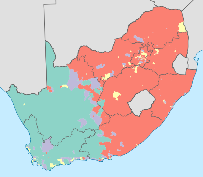
English: Map showing the dominant population groups in South Africa, according to Census 2011, at electoral ward level. A population group is considered dominant if it makes up more than 50% of the population in a ward, or if it makes up more than 33% and no other group makes up more than 25%.
Black African
Coloured
Indian or Asian
White
No group dominant
Projection is Albers Equal-Area Conic, with standard parallels at 25.5° S and 31.5° S, and origin at 28.5° S 25.5° E. |
| თარიღი | |
| წყარო | Statistics South Africa's Census 2011 is the source of the basic population data. The map results from my own processing of the data. The map results from my own processing of the data. For ward boundaries see File:South Africa electoral wards 2011 blank.svg. |
| ავტორი | Htonl |
| სხვა ვერსიები |
South Africa 2011 dominant population group map (hex cells).svg: .svg) |
ლიცენზია
The following license applies to the population data on which the map is based:

|
ამ ნამუშევრის მფლობელი, Stats SA, ნებას აძლევს ყველას გამოიყენოს იგი ნებისმიერი მიზნით იმ პირობით, თუ მფლობელი მოხსენიებული იქნება. ნამუშევრის გავრცელება, გადაცემა და კომერციული გამოყენება დაშვებულია. |
ავტორის მითითება:
"the user acknowledges Stats SA as the source of the basic data wherever they process, apply, utilise, publish or distribute the data, and also that they specify that the relevant application and analysis (where applicable) result from their own processing of the data" [1]
|
The following tag applies to the map itself:
| მე, ამ ნამუშევრის საავტორო უფლების მფლობელი, გადავცემ მას საზოგადოებრივ დომენში. ეს უფლება ვრცელდება მთელი მსოფლიოს მასშტაბით. ზოგიერთ ქვეყანაში ეს შეიძლება იურიდიულად შეუძლებელი იყოს, ასეთ შემთხვევაში: მე ვაძლევ უფლებას ნებისმიერს, რათა გამოიყენონ ეს ნამუშევარი ნებისმიერი მიზნით, ყოველგვარი წინაპირობის გარეშე, გარდა კანონით გათვალისწინებული შემთხვევებისა. |
ფაილის ისტორია
დააწკაპუნეთ თარიღზე/დროზე ფაილის დასათვალიერებლად, როგორც ის მაშინ გამოიყურებოდა.
| თარიღი/დრო | მინიატიურა | ზომები | მომხმარებელი | შენიშვნა | |
|---|---|---|---|---|---|
| მიმდინარე | 00:13, 17 აპრილი 2013 | | 809×709 (787 კბ) | Htonl | =={{int:filedesc}}== {{Information |Description={{en|1=Map showing the dominant population groups in South Africa, according to Census 2011, at electoral ward level. A population group is considered dominant if it makes up more than 50% of the populati... |
ბმულები
ამ ფაილზე ბმული მოცემულია შემდეგ გვერდებზე:
ფაილის გლობალური გამოყენება
ეს ფაილი გამოიყენება შემდეგ ვიკებში:
- გამოყენება af.wikipedia.org-ში
- გამოყენება cs.wikipedia.org-ში
- გამოყენება es.wikipedia.org-ში
- გამოყენება fr.wikipedia.org-ში
- გამოყენება he.wikipedia.org-ში
- გამოყენება it.wikipedia.org-ში
- გამოყენება pt.wikipedia.org-ში
- გამოყენება ro.wikipedia.org-ში
- გამოყენება ru.wikipedia.org-ში
- გამოყენება sr.wikipedia.org-ში
- გამოყენება tg.wikipedia.org-ში
- გამოყენება uk.wikipedia.org-ში
- გამოყენება zh.wikipedia.org-ში