
ფაილი:Mbini.PNG
თავდაპირველი ფაილი ((1 918 × 1 382 პიქსელი, ფაილის ზომა: 998 კბ, MIME ტიპი: image/png))
| ეს ფაილი მდებარეობს Wikimedia Commons სერვერზე. იხილეთ მისი აღწერის გვერდი სრული ინფორმაციისთვის. |
 |
გადასვლა ფაილის გვერდზე |
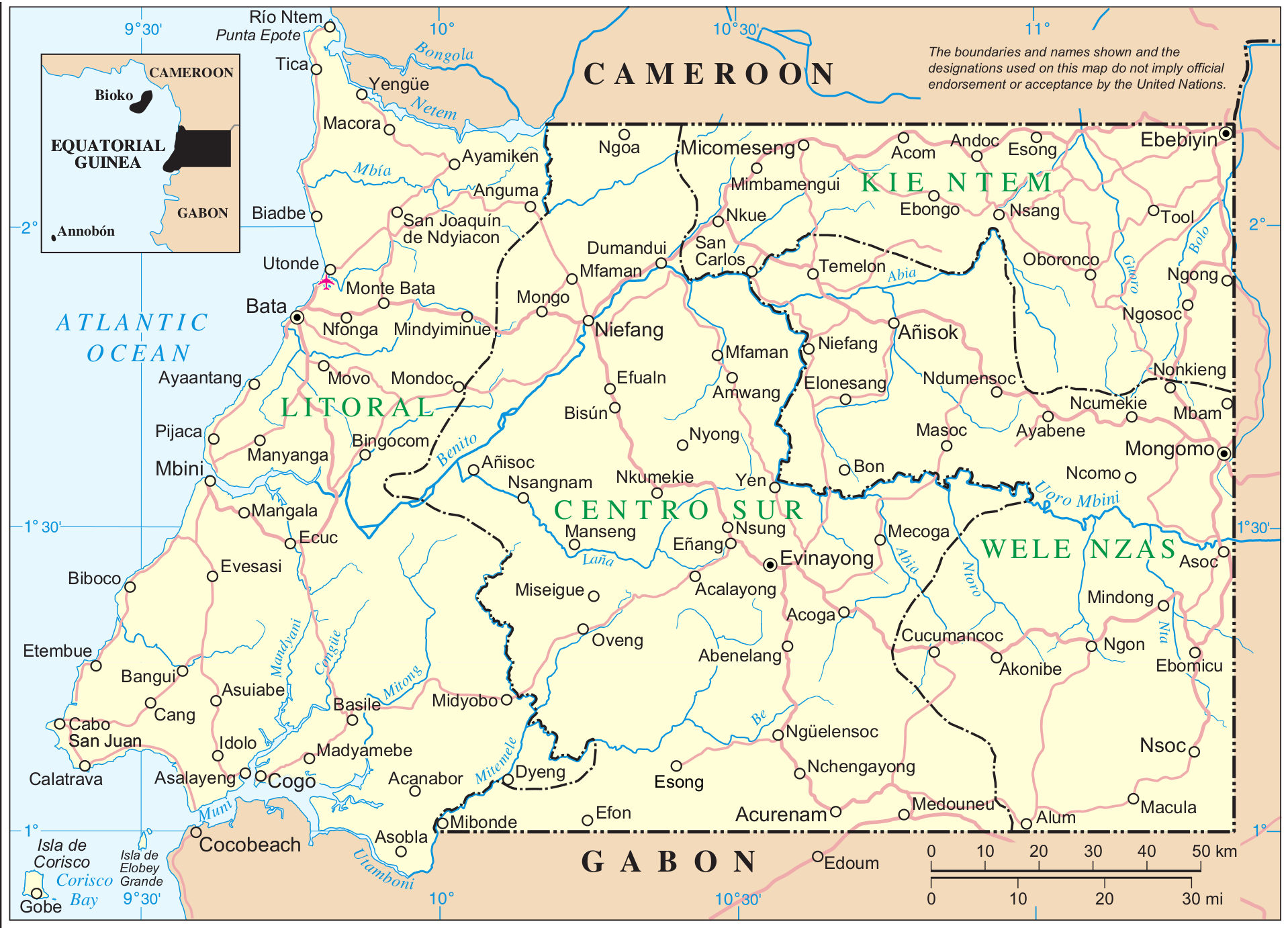
Mapa de Mbini. Guinea Ecuatorial
| This image is a map derived from a United Nations map.
Unless stated otherwise, UN maps are to be considered in the public domain. This applies worldwide. UN maps are, in principle, open source material and you can use them in your work or for making your own map. UN requests however that you delete the UN name, logo and reference number upon any modification to the map. Content of your map will be your responsibility. You can state in your publication, if you wish, something like: based on UN map … (map name, map number, revision number and date). See: Geospatial Information Section. And: Geospatial, location data for a better world. |
 |
Fuente: http://www.un.org/Depts/Cartographic/map/profile/eqguinea.pdf
ფაილის ისტორია
დააწკაპუნეთ თარიღზე/დროზე ფაილის დასათვალიერებლად, როგორც ის მაშინ გამოიყურებოდა.
| თარიღი/დრო | მინიატიურა | ზომები | მომხმარებელი | შენიშვნა | |
|---|---|---|---|---|---|
| მიმდინარე | 11:12, 7 სექტემბერი 2014 | | 1 918×1 382 (998 კბ) | Basquetteur | Higher resolution map |
| 03:49, 20 მაისი 2005 |  | 844×606 (142 კბ) | Taichi | Mapa de Mbini. Guinea Ecuatorial {{PD}} Fuente: http://www.un.org/Depts/Cartographic/map/profile/eqguinea.pdf |
ბმულები
ამ ფაილზე ბმული მოცემულია შემდეგ გვერდებზე:
ფაილის გლობალური გამოყენება
ეს ფაილი გამოიყენება შემდეგ ვიკებში:
- გამოყენება af.wikipedia.org-ში
- გამოყენება an.wikipedia.org-ში
- გამოყენება ast.wikipedia.org-ში
- გამოყენება bg.wikipedia.org-ში
- გამოყენება ca.wikipedia.org-ში
- გამოყენება de.wikipedia.org-ში
- გამოყენება de.wikivoyage.org-ში
- გამოყენება en.wikipedia.org-ში
- გამოყენება eo.wikipedia.org-ში
- გამოყენება es.wikipedia.org-ში
- გამოყენება eu.wikipedia.org-ში
- გამოყენება ff.wikipedia.org-ში
- გამოყენება fi.wikipedia.org-ში
- გამოყენება fr.wikipedia.org-ში
- გამოყენება fr.wiktionary.org-ში
- გამოყენება gl.wikipedia.org-ში
- გამოყენება ha.wikipedia.org-ში
- გამოყენება hr.wikipedia.org-ში
- გამოყენება ig.wikipedia.org-ში
- გამოყენება it.wikipedia.org-ში
- გამოყენება it.wikivoyage.org-ში
- გამოყენება ja.wikipedia.org-ში
- გამოყენება ko.wikipedia.org-ში
- გამოყენება lt.wikipedia.org-ში
იხილეთ, ამ ფაილის გლობალური გამოყენება.