
ფაილი:Map indicating Hudson Strait, Nunavut, Canada.png
უფრო მაღალი გარჩევადობა არ არის შესაძლებელი.
Map_indicating_Hudson_Strait,_Nunavut,_Canada.png ((410 × 370 პიქსელი, ფაილის ზომა: 52 კბ, MIME ტიპი: image/png))
| ეს ფაილი მდებარეობს Wikimedia Commons სერვერზე. იხილეთ მისი აღწერის გვერდი სრული ინფორმაციისთვის. |
 |
გადასვლა ფაილის გვერდზე |
რეზიუმე
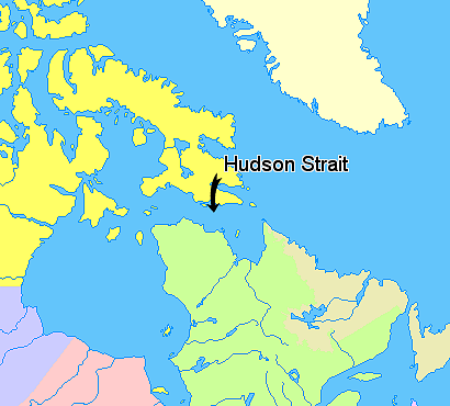
Map indicating Hudson Strait, Nunavut, Canada.
Nunavut
Greenland
Quebec
Newfoundland and Labrador
Manitoba
Ontario
© Her Majesty the Queen in Right of Canada, Department of Natural Resources. All rights reserved.
Licence Agreement
ლიცენზია

|
The copyright holder of this work allows anyone to use it for any purpose including unrestricted redistribution, commercial use, and modification.
Usage notes:
|
ფაილის ისტორია
დააწკაპუნეთ თარიღზე/დროზე ფაილის დასათვალიერებლად, როგორც ის მაშინ გამოიყურებოდა.
| თარიღი/დრო | მინიატიურა | ზომები | მომხმარებელი | შენიშვნა | |
|---|---|---|---|---|---|
| მიმდინარე | 13:55, 21 მარტი 2006 | | 410×370 (52 კბ) | David Kernow~commonswiki | == Summary == Map indicating Hudson Strait, Nunavut, Canada. {{legend|#ffff66|Nunavut}} {{legend|#ffffcc|Greenland}} {{legend|#d5fe94|Quebec}} {{legend|#ecebb6|Newfoundland and Labrador}} {{legend|#ccccff|Manitoba}} {{legend|#ffcccc|O |
ბმულები
ამ ფაილზე ბმული მოცემულია შემდეგ გვერდებზე:
ფაილის გლობალური გამოყენება
ეს ფაილი გამოიყენება შემდეგ ვიკებში:
- გამოყენება ar.wikipedia.org-ში
- გამოყენება az.wikipedia.org-ში
- გამოყენება ba.wikipedia.org-ში
- გამოყენება bg.wikipedia.org-ში
- გამოყენება bn.wikipedia.org-ში
- გამოყენება ca.wikipedia.org-ში
- გამოყენება cs.wikipedia.org-ში
- გამოყენება da.wikipedia.org-ში
- გამოყენება de.wikipedia.org-ში
- გამოყენება en.wikipedia.org-ში
- გამოყენება eo.wikipedia.org-ში
- გამოყენება eu.wikipedia.org-ში
- გამოყენება fa.wikipedia.org-ში
- გამოყენება fi.wikipedia.org-ში
- გამოყენება fr.wikipedia.org-ში
- გამოყენება gl.wikipedia.org-ში
- გამოყენება he.wikipedia.org-ში
- გამოყენება hr.wikipedia.org-ში
- გამოყენება id.wikipedia.org-ში
- გამოყენება it.wikipedia.org-ში
- გამოყენება la.wikipedia.org-ში
- გამოყენება li.wikipedia.org-ში
- გამოყენება lt.wikipedia.org-ში
- გამოყენება mhr.wikipedia.org-ში
- გამოყენება ml.wikipedia.org-ში
- გამოყენება nl.wikipedia.org-ში
- გამოყენება nn.wikipedia.org-ში
- გამოყენება no.wikipedia.org-ში
- გამოყენება pl.wikipedia.org-ში
- გამოყენება pt.wikipedia.org-ში
- გამოყენება ru.wikipedia.org-ში
- გამოყენება simple.wikipedia.org-ში
- გამოყენება sk.wikipedia.org-ში
- გამოყენება sl.wikipedia.org-ში
- გამოყენება sr.wikipedia.org-ში
- გამოყენება sv.wikipedia.org-ში
- გამოყენება sw.wikipedia.org-ში
- გამოყენება uz.wikipedia.org-ში
- გამოყენება vi.wikipedia.org-ში
- გამოყენება war.wikipedia.org-ში