
ფაილი:Madeira's Laurissilva Forest.jpg

ზომა წინასწარი გადახედვისას: 629 × 599 პიქსელი. სხვა გაფართოება: 252 × 240 პიქსელი | 504 × 480 პიქსელი | 806 × 768 პიქსელი | 1 075 × 1 024 პიქსელი | 2 150 × 2 048 პიქსელი | 3 147 × 2 998 პიქსელი.
თავდაპირველი ფაილი ((3 147 × 2 998 პიქსელი, ფაილის ზომა: 2,09 მბ, MIME ტიპი: image/jpeg))
| ეს ფაილი მდებარეობს Wikimedia Commons სერვერზე. იხილეთ მისი აღწერის გვერდი სრული ინფორმაციისთვის. |
 |
გადასვლა ფაილის გვერდზე |
რეზიუმე
| აღწერა |
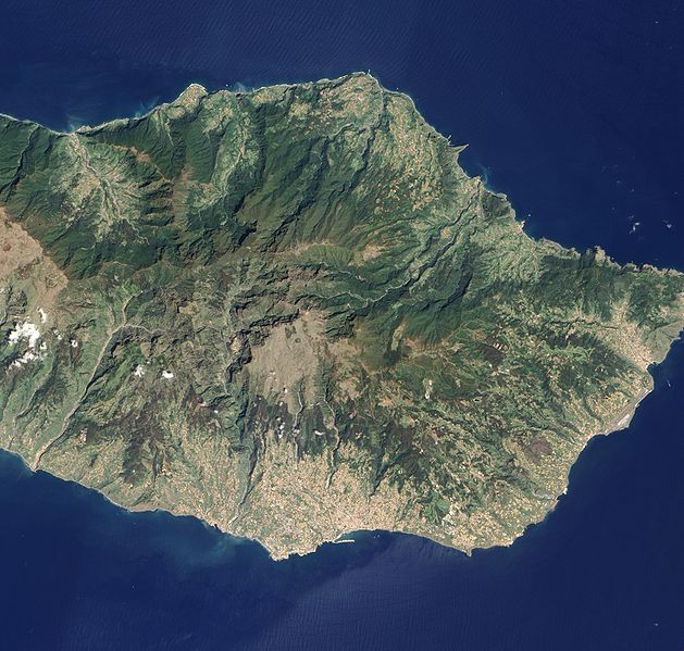
English: Detailed, true-colour image of Madeira. The image shows that deep green forest survives intact on the steep northern slopes of the island, but in the south, where terrain is gentler, the terracotta colour of towns and the light green colour of agriculture are more dominant. |
| თარიღი | |
| წყარო | NASA Earth Observatory |
| ავტორი | Jesse Allen and Robert Simmon |
Image captured by the Advanced Land Imager (ALI) on NASA’s Earth Observing-1 satellite.
ლიცენზია
| This file is in the public domain in the United States because it was solely created by NASA. NASA copyright policy states that "NASA material is not protected by copyright unless noted". (See Template:PD-USGov, NASA copyright policy page or JPL Image Use Policy.) | ||
 |
Warnings:
|
| Annotations | This image is annotated: View the annotations at Commons |
ფაილის ისტორია
დააწკაპუნეთ თარიღზე/დროზე ფაილის დასათვალიერებლად, როგორც ის მაშინ გამოიყურებოდა.
| თარიღი/დრო | მინიატიურა | ზომები | მომხმარებელი | შენიშვნა | |
|---|---|---|---|---|---|
| მიმდინარე | 11:24, 17 მაისი 2010 | | 3 147×2 998 (2,09 მბ) | Originalwana | {{Information |Description={{en|1=Detailed, true-colour image of Madeira. The image shows that deep green forest survives intact on the steep northern slopes of the island, but in the south, where terrain is gentler, the [[:Category:Terracotta |
ბმულები
ამ ფაილზე ბმული მოცემულია შემდეგ გვერდებზე:
ფაილის გლობალური გამოყენება
ეს ფაილი გამოიყენება შემდეგ ვიკებში:
- გამოყენება en.wikipedia.org-ში
- გამოყენება id.wikipedia.org-ში
- გამოყენება pt.wikipedia.org-ში