
ფაილი:London Thames Sunset panorama - Feb 2008.jpg

ზომა წინასწარი გადახედვისას: 800 × 297 პიქსელი. სხვა გაფართოება: 320 × 119 პიქსელი | 640 × 238 პიქსელი | 1 024 × 380 პიქსელი | 1 280 × 475 პიქსელი | 2 560 × 951 პიქსელი | 13 126 × 4 876 პიქსელი.
თავდაპირველი ფაილი ((13 126 × 4 876 პიქსელი, ფაილის ზომა: 17,7 მბ, MIME ტიპი: image/jpeg))
| ეს ფაილი მდებარეობს Wikimedia Commons სერვერზე. იხილეთ მისი აღწერის გვერდი სრული ინფორმაციისთვის. |
 |
გადასვლა ფაილის გვერდზე |
რეზიუმე
| აღწერა |
العربية: صُورة پانوراميَّة من عدَّة مقاطع لأُفق لندن من على ضفَّة برموندساي لنهر التيمز.
Čeština: Podvečerní panorama Londýna
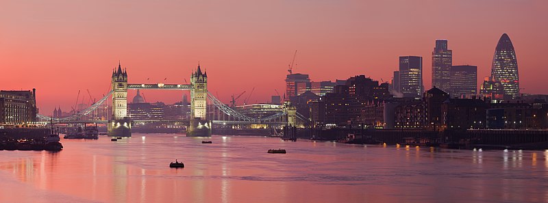
English: A multi segment panoramic image of the London skyline from the Bermondsey banks of the Thames, in which the Tower Bridge and 30 St Mary Axe are visible.
|
| თარიღი | თებერვალი 2008 (18 თებერვალი 2008, according to Exif data) |
| წყარო | პირადი ნამუშევარი |
| ავტორი | Diliff |
| უფლება (ფაილის მეორეული გამოყენება) |
Summary:In using this image or any subsequent derivatives of it, you are required to release the image under the same license. As such, any reproduction of this image, in any medium, must appear with a copy of, or full URL of the license.Attribution of this image to the author (DAVID ILIFF) is also required, preferably in a prominent location near the image.No other conditions may be added to, or removed from this license without the permission of the author and copyright holder.Suggested attribution: "Photo by DAVID ILIFF. License: CC BY-SA 3.0"Please review the full license requirements carefully before using this image. If you would like to clarify the terms of the license or negotiate less restrictive commercial licensing outside of the bounds of GFDL/CC-BY-SA, please contact me by email, or if you don't have a Wikipedia account you can either leave a message on my talk page with your contact details and your request, or you can contact me on Facebook. Please also send a 'friend request' to ensure that I am aware of your message. |
| სხვა ვერსიები |
Derivative works of this file: |
| კამერის მდებარეობა | | იხილეთ ეს და სხვა ახლომდებარე სურათები საიტ(ებ)ზე OpenStreetMap |
|---|
|

.jpg)
This image was selected as picture of the day on Wikimedia Commons for 27 July 2012. It was captioned as follows: Other languages:
Русский: Панорама Лондона, столицы Олимпийских игр 2012 года മലയാളം : ലണ്ടൻ, 2012 ഒളിമ്പിക്സിന്റെ ആതിഥേയ പട്ടണം. |
ლიცენზია
მე, ამ ნაწარმოებზე საავტორო უფლებების მფლობელი, საკუთარი სურვილით ვაქვეყნებ მას შემდეგი ლიცენზიით:

|
თქვენ შეგიძიათ გაავრცელოთ ან შეცვალოთ დოკუმენტი GNU Free Documentation ლიცენზიის 1.2 ან უფრო გვიანდელი ვერსიის პირობების თანახმად, რომელიც გამოქვეყნებულია თავისუფალი პროგრამული უზრუნველყოფის ფონდის მიერ, შეუცვლელი განყოფილებების გარეშე, პირველ და ბოლო გვერდებზე განთავსებულ ტექსტებზე. ლიცენზიის ასლი არის განთავსებული განყოფილებაში სახელად GNU Free Documentation License. |
ეს ფაილი ვრცელდება Creative Commons Attribution 3.0 Unported ლიცენზიით.
- თქვენ თავისუფლად შეგიძლიათ:
- ნამუშევრის გაზიარება – ნამუშევრის კოპირება, გავრცელება და გადაცემა.
- შექმნათ დაფუძნებულები – ნამუშევრის შესწორება
- შემდეგი პირობებით:
- მოხსენიება – თქვენ უნდა მიუთითოთ წყაროს შემქმნელი იმ გზით, რომელიც დანიშნა ავტორმა ან საავტორო უფლებების მფლობელმა. მაგრამ არა ისე, თითქოს წყაროს ავტორი მხარს გიჭერთ თქვენ ან დაუჭირა თქვენს მიერ შექმნილ ნაწარმოებს.
თქვენ შეგიძლიათ აირჩიოთ ლიცენზია.
ფაილის ისტორია
დააწკაპუნეთ თარიღზე/დროზე ფაილის დასათვალიერებლად, როგორც ის მაშინ გამოიყურებოდა.
| თარიღი/დრო | მინიატიურა | ზომები | მომხმარებელი | შენიშვნა | |
|---|---|---|---|---|---|
| მიმდინარე | 17:39, 18 მაისი 2015 | 13 126×4 876 (17,7 მბ) | Diliff | fixed stitching error | |
| 17:26, 10 მაისი 2015 | 13 126×4 876 (17,63 მბ) | Diliff | higher resolution version | ||
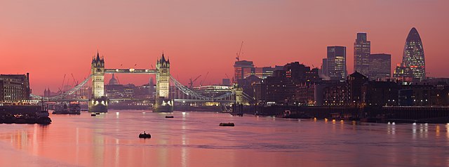
| 13:23, 1 მარტი 2008 | 2 500×932 (685 კბ) | Diliff | {{Information |Description=A multi segment panoramic image of the London skyline from the Bermondsey banks of the Thames. Taken by myself with a Canon 5D and 70-200mm f/2.8L lens. |Source=self-made |Date=Feb 2008 |Author= Diliff |Permissio |
ბმულები
ამ ფაილზე ბმული მოცემულია შემდეგ გვერდებზე:
ფაილის გლობალური გამოყენება
ეს ფაილი გამოიყენება შემდეგ ვიკებში:
- გამოყენება ace.wikipedia.org-ში
- გამოყენება af.wikipedia.org-ში
- გამოყენება am.wikipedia.org-ში
- გამოყენება ar.wikipedia.org-ში
- بوابة:أوروبا
- نهر التمز
- مستخدم:ديفيد/صور ساهمت في جعلها مختارة
- بوابة:إنجلترا/صورة مختارة
- بوابة:إنجلترا/صورة مختارة/أرشيف
- ويكيبيديا:ترشيحات الصور المختارة/جسر البرج بلندن
- بوابة:إنجلترا/صورة مختارة/9
- ويكيبيديا:صور مختارة/أماكن/رؤية شاملة
- بوابة:أوروبا/صورة مختارة/أرشيف
- بوابة:أوروبا/صورة مختارة/8
- ويكيبيديا:صورة اليوم المختارة/يوليو 2015
- قالب:صورة اليوم المختارة/2015-07-14
- ويكيبيديا:صورة اليوم المختارة/سبتمبر 2016
- قالب:صورة اليوم المختارة/2016-09-21
- ويكيبيديا:صورة اليوم المختارة/يوليو 2018
- قالب:صورة اليوم المختارة/2018-07-10
- ويكيبيديا:صورة اليوم المختارة/يوليو 2021
- قالب:صورة اليوم المختارة/2021-07-05
- გამოყენება ast.wikipedia.org-ში
- გამოყენება azb.wikipedia.org-ში
- გამოყენება ban.wikipedia.org-ში
- გამოყენება bcl.wikipedia.org-ში
- გამოყენება be-tarask.wikipedia.org-ში
- გამოყენება be.wikipedia.org-ში
- გამოყენება bh.wikipedia.org-ში
- გამოყენება bn.wikipedia.org-ში
- გამოყენება bn.wikivoyage.org-ში
- გამოყენება bo.wikipedia.org-ში
- გამოყენება br.wikipedia.org-ში
- გამოყენება bs.wikipedia.org-ში
- გამოყენება crh.wikipedia.org-ში
- გამოყენება cv.wikipedia.org-ში
- გამოყენება cy.wikipedia.org-ში
- გამოყენება da.wikipedia.org-ში
- გამოყენება de.wikipedia.org-ში
იხილეთ, ამ ფაილის გლობალური გამოყენება.