
ფაილი:KangnidoMap.jpg
უფრო მაღალი გარჩევადობა არ არის შესაძლებელი.
KangnidoMap.jpg ((600 × 556 პიქსელი, ფაილის ზომა: 81 კბ, MIME ტიპი: image/jpeg))
| ეს ფაილი მდებარეობს Wikimedia Commons სერვერზე. იხილეთ მისი აღწერის გვერდი სრული ინფორმაციისთვის. |
 |
გადასვლა ფაილის გვერდზე |
რეზიუმე
| სათაური |
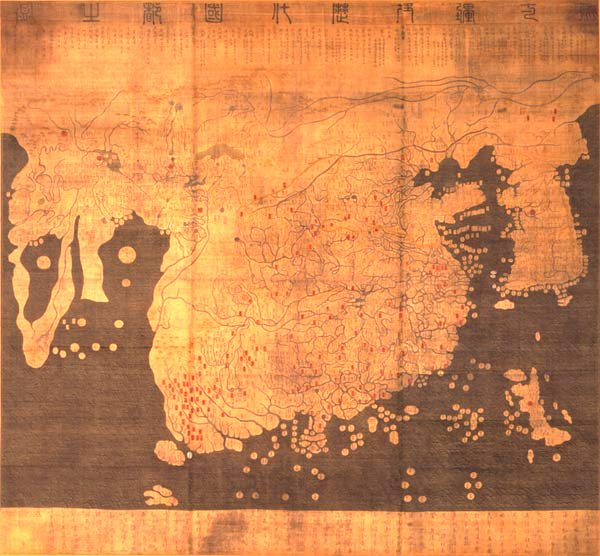
English: Kangnido 한국어: 혼일강리역대국도지도 |
|||||||||
| Description |
English: Kangnido map (1402). The later Honkōji version of the map is available here: GeneralMapOfDistancesAndHistoricCapitals.jpg at a higher resolution. 한국어: 혼일강리역대국도지도. |
|||||||||
| თარიღი | ||||||||||
| წყარო | ... | |||||||||
| შემქმნელი |
Kim Sahyung, Lee Moo, Lee Hui |
|||||||||
| Geotemporal data | ||||||||||
| Date depicted | ||||||||||
| Bounding box |
|
|||||||||
| Georeferencing | ||||||||||
| Bibliographic data | ||||||||||
| ენა | Hanja | |||||||||
ლიცენზია
|
This is a faithful photographic reproduction of a two-dimensional, public domain work of art. The work of art itself is in the public domain for the following reason:
The official position taken by the Wikimedia Foundation is that "faithful reproductions of two-dimensional public domain works of art are public domain".
This photographic reproduction is therefore also considered to be in the public domain in the United States. In other jurisdictions, re-use of this content may be restricted; see Reuse of PD-Art photographs for details. | ||||
ფაილის ისტორია
დააწკაპუნეთ თარიღზე/დროზე ფაილის დასათვალიერებლად, როგორც ის მაშინ გამოიყურებოდა.
| თარიღი/დრო | მინიატიურა | ზომები | მომხმარებელი | შენიშვნა | |
|---|---|---|---|---|---|
| მიმდინარე | 16:29, 22 მარტი 2005 | | 600×556 (81 კბ) | Julgon~commonswiki | Kangnido map (1402) from en.wikipedia.org |
ბმულები
ამ ფაილზე ბმული მოცემულია შემდეგ გვერდებზე:
ფაილის გლობალური გამოყენება
ეს ფაილი გამოიყენება შემდეგ ვიკებში:
- გამოყენება ar.wikipedia.org-ში
- გამოყენება azb.wikipedia.org-ში
- გამოყენება bn.wikipedia.org-ში
- გამოყენება br.wikipedia.org-ში
- გამოყენება bs.wikipedia.org-ში
- გამოყენება ca.wikipedia.org-ში
- გამოყენება cy.wikipedia.org-ში
- გამოყენება da.wikipedia.org-ში
- გამოყენება da.wikibooks.org-ში
- გამოყენება de.wikipedia.org-ში
- გამოყენება en.wikipedia.org-ში
- გამოყენება en.wikiquote.org-ში
- გამოყენება eo.wikipedia.org-ში
- გამოყენება es.wikipedia.org-ში
- გამოყენება et.wikipedia.org-ში
- გამოყენება eu.wikipedia.org-ში
- გამოყენება fa.wikipedia.org-ში
- გამოყენება fa.wikibooks.org-ში
- გამოყენება fi.wikipedia.org-ში
- გამოყენება fr.wikipedia.org-ში
- გამოყენება gl.wikipedia.org-ში
იხილეთ, ამ ფაილის გლობალური გამოყენება.