
ფაილი:Island of Ireland location map Leitrim.svg

ამ SVG ფაილის PNG წინასწარი გადახედვის ზომაა: 481 × 599 პიქსელი. სხვა გაფართოება: 192 × 240 პიქსელი | 385 × 480 პიქსელი | 616 × 768 პიქსელი | 822 × 1 024 პიქსელი | 1 643 × 2 048 პიქსელი | 1 450 × 1 807 პიქსელი.
თავდაპირველი ფაილი (ფაილი SVG, ნომინალურად 1 450 × 1 807 პიქსელი, ფაილის ზომა: 642 კბ)
| ეს ფაილი მდებარეობს Wikimedia Commons სერვერზე. იხილეთ მისი აღწერის გვერდი სრული ინფორმაციისთვის. |
 |
გადასვლა ფაილის გვერდზე |
| აღწერა |
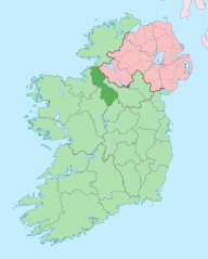
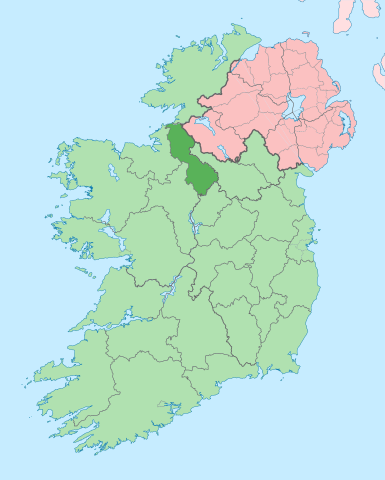
English: The island of Ireland, showing international border between Ireland and Northern Ireland, traditional provinces, traditional counties, and local authority areas in Ireland and Northern Ireland. |
| თარიღი | (UTC) |
| წყარო | |
| ავტორი |
|
| ეს არის რედაქტირებული ფაილი, რომლის ორიგინალი იყო ციფრულად დამუშავებული.ცვლილება შემდეგია: Coloured in regions with county of article highlighted. ორიგინალი ინახება აქ: Island of Ireland location map.svg. რედაქტირება მოახდინა Mabuska.
|
მე, ამ ნამუშევარზე საავტორო უფლებების მფლობელი, ვაქვეყნებ მას შემდეგი ლიცენზიით:
ეს ნამუშევარი ვრცელდება Creative Commons Attribution-Share Alike 3.0 Unported ლიცენზიით.
- თქვენ თავისუფლად შეგიძლიათ:
- ნამუშევრის გაზიარება – ნამუშევრის კოპირება, გავრცელება და გადაცემა.
- შექმნათ დაფუძნებულები – ნამუშევრის შესწორება
- შემდეგი პირობებით:
- მოხსენიება – თქვენ უნდა მიუთითოთ წყაროს შემქმნელი იმ გზით, რომელიც დანიშნა ავტორმა ან საავტორო უფლებების მფლობელმა. მაგრამ არა ისე, თითქოს წყაროს ავტორი მხარს გიჭერთ თქვენ ან დაუჭირა თქვენს მიერ შექმნილ ნაწარმოებს.
- გავრცელება იგივე პირობებეით – თუ თქვენ ცვლით, ან ქმნით ახალ ნაშრომს ამ ნამუშევრის გამოყენებთ, თქვენ გაქვთ უფლება გაავრცელოთ იგი იგივე ან შესაბამისი ლიცენზიით, რომლითაც ვრცელდება წყარო.
ატვირთვის ჟურნალი
This image is a derivative work of the following images:
- File:Island_of_Ireland_location_map.svg licensed with Cc-by-sa-3.0
- 2010-03-06T20:43:33Z Rannpháirtí anaithnid 1450x1807 (679207 Bytes) Fix incorrectly coloured isands.
- 2010-03-03T22:19:29Z Rannpháirtí anaithnid 1450x1807 (679744 Bytes) {{Information |Description={{de|Positionskarte von [[:de:Irland|Irland]]}} Quadratische Plattkarte, N-S-Streckung 170 %. Geographische Begrenzung der Karte: * N: 55.6° N * S: 51.2° N * W: 11.0° W * O: 5.0° W {{en|Location
Uploaded with derivativeFX
ფაილის ისტორია
დააწკაპუნეთ თარიღზე/დროზე ფაილის დასათვალიერებლად, როგორც ის მაშინ გამოიყურებოდა.
| თარიღი/დრო | მინიატიურა | ზომები | მომხმარებელი | შენიშვნა | |
|---|---|---|---|---|---|
| მიმდინარე | 14:00, 28 ივნისი 2020 | | 1 450×1 807 (642 კბ) | Chipmunkdavis | Per the Local Government Reform Act 2014, joining both Tipperarys and both Waterfords (and removing Limerick City code). Colouring in islands, cleaning up and grouping code to remove stray objects and show Galway and Lough Ree. |
| 00:51, 19 ივლისი 2010 |  | 1 450×1 807 (815 კბ) | Mabuska | {{Information |Description={{en|The island of Ireland, showing international border between Northern Ireland and Republic of Ireland, traditional provinces, traditional counties, and local authority areas in the Republic of Ireland and Northern Ireland.}} |
ბმულები
ამ ფაილზე ბმული მოცემულია შემდეგ გვერდებზე:
- ახამორი
- ბაკოდი
- ბალინაგლერა
- ბალინამორი
- დრამკირანი
- დრამკონგი
- დრამსნა
- დრამშანბო
- დრომაჰერი
- დრომოდი
- ესლინბრიჯი
- კარიგალენი
- კერიკ-ონ-შენონი
- კეშკარიგანი
- კილტიკლოხერი
- კინლოხი
- კლუნი
- ლარგიდონელი
- ლიტრიმი (სოფელი)
- ლიტრიმის საგრაფო
- მანორჰამილტონი
- მოჰილი
- ნიუტაუნგორი
- როსინვერი
- ტულახანი
- ფენა (ლიტრიმის საგრაფო)
- ჯეიმზტაუნი (ლიტრიმის საგრაფო)
- თარგი:ლიტრიმის დასახლებები
ფაილის გლობალური გამოყენება
ეს ფაილი გამოიყენება შემდეგ ვიკებში:
- გამოყენება ar.wikipedia.org-ში
- გამოყენება ast.wikipedia.org-ში
- გამოყენება bg.wikipedia.org-ში
- გამოყენება ca.wikipedia.org-ში
- გამოყენება ceb.wikipedia.org-ში
- გამოყენება cs.wikipedia.org-ში
- გამოყენება de.wikivoyage.org-ში
- გამოყენება en.wikipedia.org-ში
- County Leitrim
- List of Ireland-related topics
- Carrick-on-Shannon
- Ballinamore
- Carrigallen
- Manorhamilton
- Dromod
- Drumshanbo
- Mohill
- Roosky
- Buckode
- Dromahair
- Drumkeeran
- Keshcarrigan
- Kiltyclogher
- Kinlough
- Largydonnell
- Leitrim, County Leitrim
- Rossinver
- Tullaghan
- R203 road (Ireland)
- Dowra
- Dartry Mountains
- Lough MacNean
- Gorvagh
- Cornashamsogue
- Template:Leitrim-geo-stub
- Dristernan
- Lavagh (Leitrim barony)
- Cloonsheebane
- Effrinagh
- Newtowngore
- Ballinaglera
- Kiltubbrid
- Aghamore
- Eslinbridge
იხილეთ, ამ ფაილის გლობალური გამოყენება.