
ფაილი:Ionian Islands.svg

ამ SVG ფაილის PNG წინასწარი გადახედვის ზომაა: 532 × 547 პიქსელი. სხვა გაფართოება: 233 × 240 პიქსელი | 467 × 480 პიქსელი | 747 × 768 პიქსელი | 996 × 1 024 პიქსელი | 1 992 × 2 048 პიქსელი.
თავდაპირველი ფაილი (ფაილი SVG, ნომინალურად 532 × 547 პიქსელი, ფაილის ზომა: 281 კბ)
| ეს ფაილი მდებარეობს Wikimedia Commons სერვერზე. იხილეთ მისი აღწერის გვერდი სრული ინფორმაციისთვის. |
 |
გადასვლა ფაილის გვერდზე |

|
This map has been uploaded by Electionworld from en.wikipedia.org to enable the |
რეზიუმე
| აღწერა |
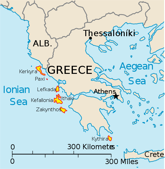
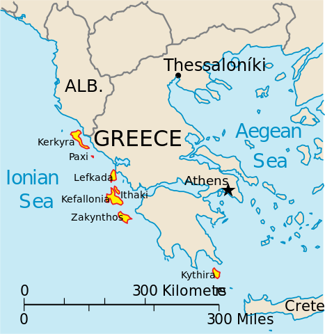
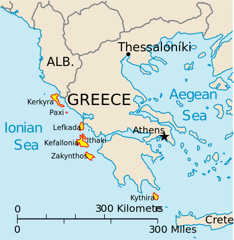
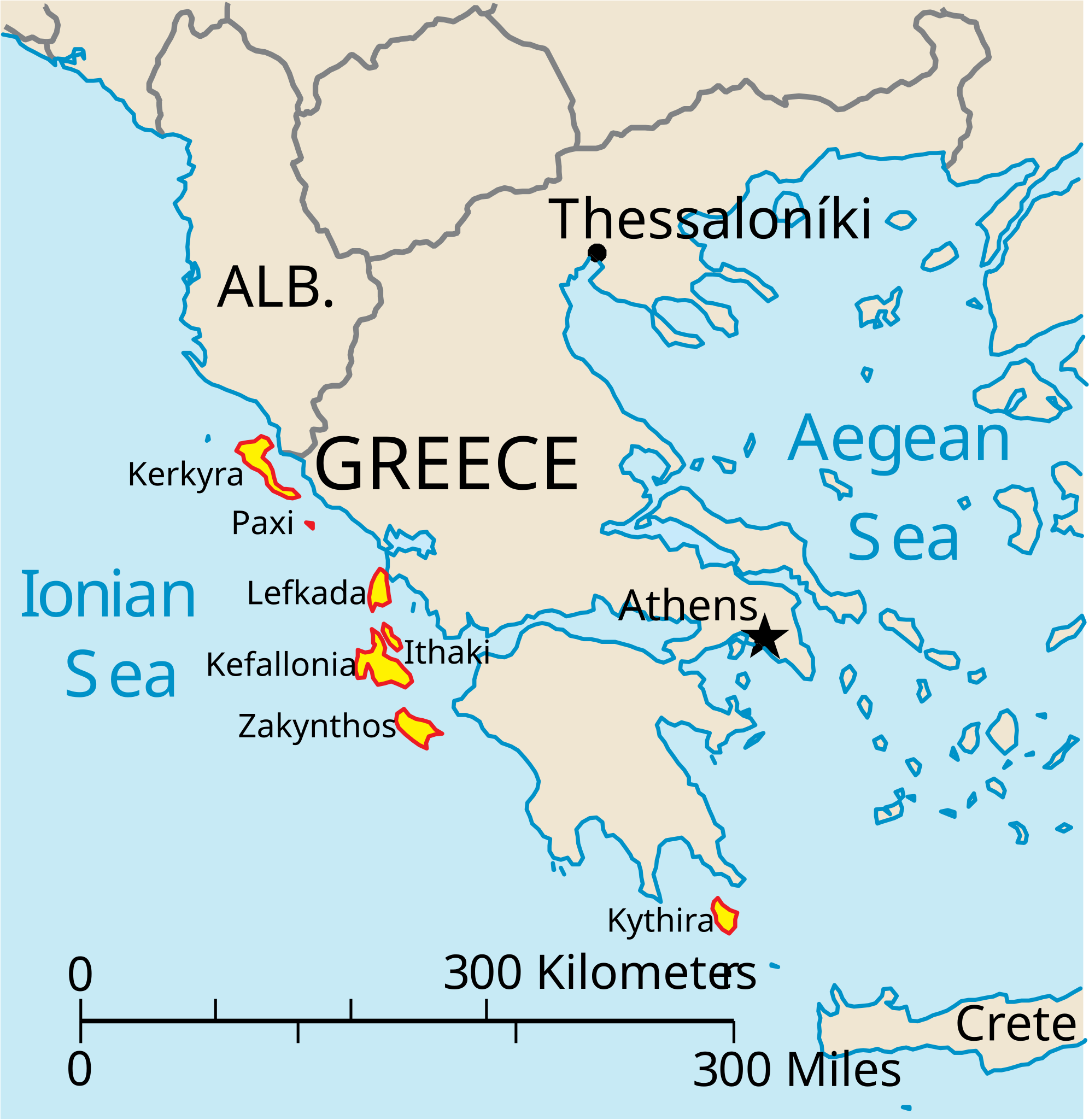
English: Map of the Ionian Islands off Greece. |
| თარიღი | |
| წყარო | პირადი ნამუშევარი, Original vector data taken from the 2006 CIA World Factbook map of Europe. All modifications were made by me, and are free for anyone to use for any purpose. |
| ავტორი | Electionworld |
| სხვა ვერსიები |
Version en français : |
ლიცენზია
ეს სურათი განთავსებულია საზოგადოებრივ დომენში რადგან ის შეიცავს მასალას რომელიც თავდაპირველად მოვიდა აშშ-ის ცენტრალური სადაზვერვო სააგენტოს World Factbook-დან.
|
 |
ფაილის ისტორია
დააწკაპუნეთ თარიღზე/დროზე ფაილის დასათვალიერებლად, როგორც ის მაშინ გამოიყურებოდა.
| თარიღი/დრო | მინიატიურა | ზომები | მომხმარებელი | შენიშვნა | |
|---|---|---|---|---|---|
| მიმდინარე | 14:39, 4 აპრილი 2010 | | 532×547 (281 კბ) | Kmusser | rm Macedonia label, not important to the map and avoids POV issue |
| 20:17, 20 დეკემბერი 2006 |  | 532×547 (258 კბ) | Electionworld | {{ew|en|IMeowbot}} == Summary == Map of the Ionian Islands off Greece. Original vector data taken from the 2006 CIA World Factbook map of Europe. All modifications were made by me, and are free for anyone to use for any purpose. == Licensing == {{PD-US |
ბმულები
ამ ფაილზე ბმული მოცემულია შემდეგ გვერდებზე:
ფაილის გლობალური გამოყენება
ეს ფაილი გამოიყენება შემდეგ ვიკებში:
- გამოყენება ar.wikipedia.org-ში
- გამოყენება ast.wikipedia.org-ში
- გამოყენება be.wikipedia.org-ში
- გამოყენება bg.wikipedia.org-ში
- გამოყენება ceb.wikipedia.org-ში
- გამოყენება ce.wikipedia.org-ში
- გამოყენება cy.wikipedia.org-ში
- გამოყენება da.wikipedia.org-ში
- გამოყენება de.wikipedia.org-ში
- გამოყენება en.wikipedia.org-ში
- გამოყენება et.wikipedia.org-ში
- გამოყენება fa.wikipedia.org-ში
- გამოყენება fi.wikipedia.org-ში
- გამოყენება fr.wikipedia.org-ში
- გამოყენება he.wikipedia.org-ში
- გამოყენება hr.wikipedia.org-ში
- გამოყენება hu.wikipedia.org-ში
- გამოყენება hyw.wikipedia.org-ში
- გამოყენება id.wikipedia.org-ში
- გამოყენება it.wikipedia.org-ში
იხილეთ, ამ ფაილის გლობალური გამოყენება.