
ფაილი:Grid 1811.jpg

ზომა წინასწარი გადახედვისას: 208 × 599 პიქსელი. სხვა გაფართოება: 250 × 720 პიქსელი.
თავდაპირველი ფაილი ((250 × 720 პიქსელი, ფაილის ზომა: 132 კბ, MIME ტიპი: image/jpeg))
| ეს ფაილი მდებარეობს Wikimedia Commons სერვერზე. იხილეთ მისი აღწერის გვერდი სრული ინფორმაციისთვის. |
 |
გადასვლა ფაილის გვერდზე |
რეზიუმე
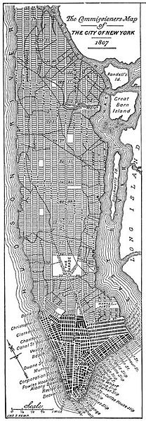
| აღწერა | The Commissioners' Plan of 1811 provisional map, released in 1807 |
| თარიღი | |
| წყარო | English Wikipedia |
| ავტორი | Jleon |
| უფლება (ფაილის მეორეული გამოყენება) |
The two-dimensional work of art depicted in this image is in the public domain in the United States, either because it was first published in 1922 or earlier, or for the reason described either above or below this message. This photograph of the work is also in the public domain in the United States (see Bridgeman Art Library v. Corel Corp.). Note: Unless the creator died more than 70 years ago, the work of art is not public domain worldwide. It is still, however, usable on the English Wikipedia, because the servers it uses are located in the United States. This information (Creator, death date, etc) should always be listed if known. |
| სხვა ვერსიები |
|

ლიცენზია
This work is in the public domain in the United States because it was published (or registered with the U.S. Copyright Office) before January 1, 1929.
Public domain works must be out of copyright in both the United States and in the source country of the work in order to be hosted on the Commons. If the work is not a U.S. work, the file must have an additional copyright tag indicating the copyright status in the source country.
Note: This tag should not be used for sound recordings. |
ფაილის ისტორია
დააწკაპუნეთ თარიღზე/დროზე ფაილის დასათვალიერებლად, როგორც ის მაშინ გამოიყურებოდა.
| თარიღი/დრო | მინიატიურა | ზომები | მომხმარებელი | შენიშვნა | |
|---|---|---|---|---|---|
| მიმდინარე | 11:53, 30 მარტი 2007 | 250×720 (132 კბ) | Jonathan71 | {{Information |Description=The Commissioners' Plan of 1811 provisional map, released in 1807 |Source=English Wikipedia |Date=21 April 2005 |Author=Jleon |Permission=The two-dimensional work of art depicted in this image is in the public domain in the Un |
ბმულები
ამ ფაილზე ბმული მოცემულია შემდეგ გვერდებზე:
ფაილის გლობალური გამოყენება
ეს ფაილი გამოიყენება შემდეგ ვიკებში:
- გამოყენება ca.wikipedia.org-ში
- გამოყენება cs.wikipedia.org-ში
- გამოყენება de.wikipedia.org-ში
- გამოყენება en.wikipedia.org-ში
- გამოყენება en.wikibooks.org-ში
- გამოყენება eo.wikipedia.org-ში
- გამოყენება es.wikipedia.org-ში
- გამოყენება eu.wikipedia.org-ში
- გამოყენება fa.wikipedia.org-ში
- გამოყენება fi.wikipedia.org-ში
- გამოყენება fr.wikipedia.org-ში
- გამოყენება he.wikipedia.org-ში
- გამოყენება ja.wikipedia.org-ში
- გამოყენება nl.wikipedia.org-ში
- გამოყენება pt.wikipedia.org-ში
- გამოყენება ru.wikipedia.org-ში
- გამოყენება uk.wikipedia.org-ში
- გამოყენება www.wikidata.org-ში