
ფაილი:British Isles Ireland higlighted.svg

ამ SVG ფაილის PNG წინასწარი გადახედვის ზომაა: 343 × 600 პიქსელი. სხვა გაფართოება: 137 × 240 პიქსელი | 274 × 480 პიქსელი | 439 × 768 პიქსელი | 586 × 1 024 პიქსელი | 1 171 × 2 048 პიქსელი | 675 × 1 180 პიქსელი.
თავდაპირველი ფაილი (ფაილი SVG, ნომინალურად 675 × 1 180 პიქსელი, ფაილის ზომა: 53 კბ)
| ეს ფაილი მდებარეობს Wikimedia Commons სერვერზე. იხილეთ მისი აღწერის გვერდი სრული ინფორმაციისთვის. |
 |
გადასვლა ფაილის გვერდზე |
რეზიუმე
| აღწერა |
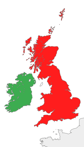
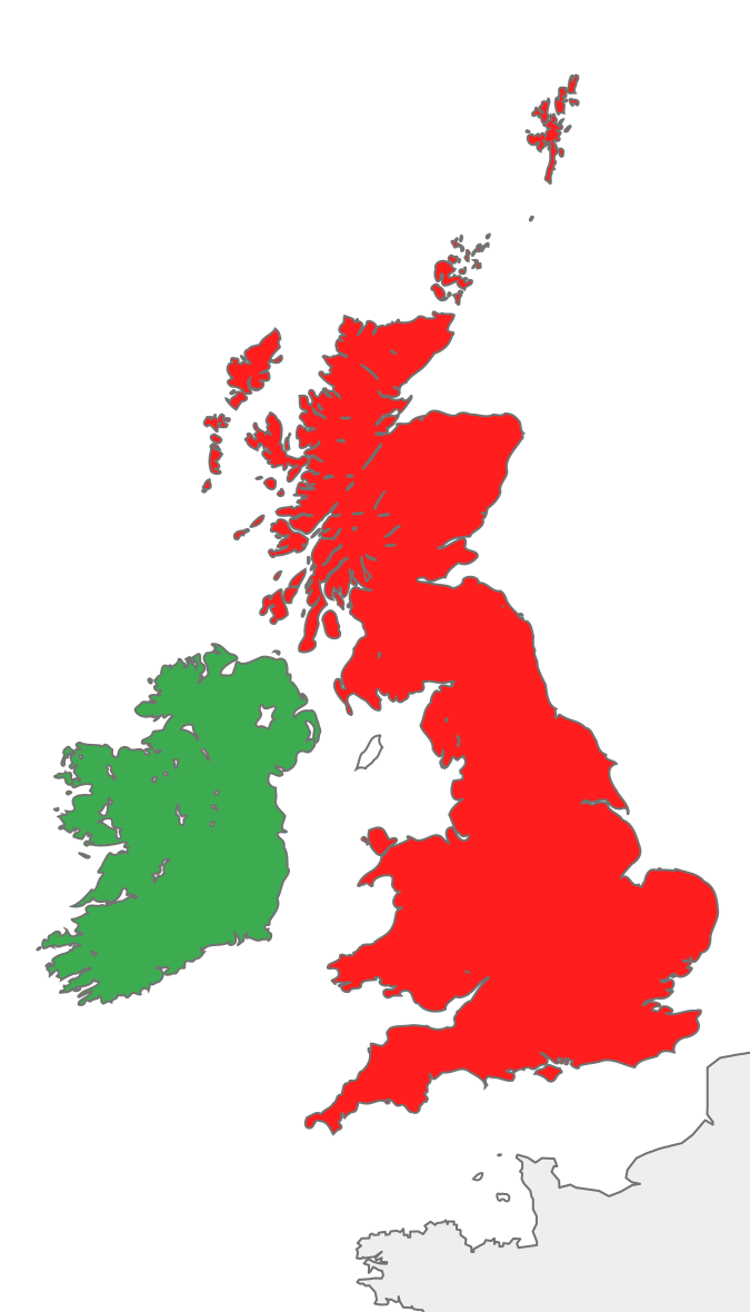
Deutsch: Karte des Vereinigten Königreichs von Großbritannien und Irland mit Markierung Irlands.
English: Map of the island of Ireland and the island of Great Britain, with green Ireland in green color. |
||
| თარიღი | |||
| წყარო |
This file was derived from: British Isles all.svg: |
||
| ავტორი | Furfur | ||
| SVG genesis | ამ SVG ფაილის კოდი კორექტულია.
|
ლიცენზია
მე, ამ ნამუშევარზე საავტორო უფლებების მფლობელი, ვაქვეყნებ მას შემდეგი ლიცენზიით:
| მე, ამ ნამუშევრის საავტორო უფლების მფლობელი, გადავცემ მას საზოგადოებრივ დომენში. ეს უფლება ვრცელდება მთელი მსოფლიოს მასშტაბით. ზოგიერთ ქვეყანაში ეს შეიძლება იურიდიულად შეუძლებელი იყოს, ასეთ შემთხვევაში: მე ვაძლევ უფლებას ნებისმიერს, რათა გამოიყენონ ეს ნამუშევარი ნებისმიერი მიზნით, ყოველგვარი წინაპირობის გარეშე, გარდა კანონით გათვალისწინებული შემთხვევებისა. |
ატვირთვის ჟურნალი
This image is a derivative work of the following images:
- British Isles all.svg licensed with PD-self
- 2012-09-14T08:21:12Z Palosirkka 675x1180 (55591 Bytes) Scrubbed with http://codedread.com/scour/
- 2007-10-20T18:30:43Z Cnbrb 675x1180 (139477 Bytes) == Summary == {{Information |Description=map of Great Britain and Ireland, also known collectively as the British Isles, or the Islands of the North Atlantic |Source=self-made |Date=2007-20-09 |Author= [[User:Cnbrb|Cnbrb]] }}
- 2007-10-20T18:28:26Z Cnbrb 675x1180 (139477 Bytes) == Summary == {{Information |Description=map of Great Britain and Ireland, also known collectively as the British Isles, or the Islands of the North Atlantic |Source=self-made |Date=2007-20-09 |Author= [[User:Cnbrb|Cnbrb]] }}
- 2007-10-20T18:27:20Z Cnbrb 675x1180 (139477 Bytes) == Summary == {{Information |Description=map of Great Britain and Ireland, also known collectively as the British Isles, or the Islands of the North Atlantic |Source=self-made |Date=2007-20-09 |Author= [[User:Cnbrb|Cnbrb]] }}
- 2007-10-20T18:26:33Z Cnbrb 675x1180 (139477 Bytes) == Summary == {{Information |Description=map of Great Britain and Ireland, also known collectively as the British Isles, or the Islands of the North Atlantic |Source=self-made |Date=2007-20-09 |Author= [[User:Cnbrb|Cnbrb]] }}
- 2007-10-20T18:14:52Z Cnbrb 675x1180 (317766 Bytes) == Summary == {{Information |Description=map of Great Britain and Ireland, also known collectively as the British Isles, or the Islands of the North Atlantic |Source=self-made |Date=2007-10-09 |Author= [[User:Cnbrb|Cnbrb]] }}
- 2007-10-20T18:10:39Z Cnbrb 675x1180 (633628 Bytes) == Summary == {{Information |Description=map of Great Britain and Ireland, also known collectively as the British Isles, or the Islands of the North Atlantic |Source=self-made |Date=2007-10-09 |Author= [[User:Cnbrb|Cnbrb]] }}
- 2007-10-20T18:08:30Z Cnbrb 675x1180 (632324 Bytes) == Summary == {{Information |Description=map of Great Britain and Ireland, also known collectively as the British Isles, or the Islands of the North Atlantic |Source=self-made |Date=2007-10-09 |Author= [[User:Cnbrb|Cnbrb]] }}
- 2007-10-20T18:04:37Z Cnbrb 675x1180 (632324 Bytes) == Summary == {{Information |Description=map of Great Britain and Ireland, also known collectively as the British Isles, or the Islands of the North Atlantic |Source=self-made |Date=2007-10-09 |Author= [[User:Cnbrb|Cnbrb]] }}
Uploaded with derivativeFX
ფაილის ისტორია
დააწკაპუნეთ თარიღზე/დროზე ფაილის დასათვალიერებლად, როგორც ის მაშინ გამოიყურებოდა.
| თარიღი/დრო | მინიატიურა | ზომები | მომხმარებელი | შენიშვნა | |
|---|---|---|---|---|---|
| მიმდინარე | 19:32, 13 თებერვალი 2018 | | 675×1 180 (53 კბ) | Geralt Riv | optimization |
| 20:53, 16 აგვისტო 2013 |  | 675×1 180 (144 კბ) | Furfur | Isle of Man and Channel islands not in red color - not part of the UK | |
| 12:02, 8 აგვისტო 2013 |  | 675×1 180 (70 კბ) | Furfur | == {{int:filedesc}} == {{Information |Description={{de|1=Karte des Vereinigten Königreichs von Großbritannien und Irland mit Markierung Irlands.}} {{en|1=Map of the United Kingdom of Great Britain and Ireland, with Ireland in green color.}} |Sour... |
ბმულები
ამ ფაილზე ბმული მოცემულია შემდეგ გვერდებზე:
ფაილის გლობალური გამოყენება
ეს ფაილი გამოიყენება შემდეგ ვიკებში:
- გამოყენება de.wikipedia.org-ში