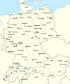
ფაილი:Rzeczpospolita 1937.svg

გვერდი სხვა ენებზე არ არის ხელმისაწვდომი.
მასალა ვიკიპედიიდან — თავისუფალი ენციკლოპედია

თავდაპირველი ფაილი(ფაილი SVG, ნომინალურად 2 220 × 1 554 პიქსელი, ფაილის ზომა: 573 კბ)

ეს ფაილი მდებარეობს Wikimedia Commons სერვერზე.
იხილეთ მისი აღწერის გვერდი სრული ინფორმაციისთვის.
გადასვლა ფაილის გვერდზე

რეზიუმე

აღწერა Test version of a vectorized File:Rzeczpospolita 1920.png; more changes will follow, only checking if wiki displays it right
თარიღი
წყარო

პირადი ნამუშევარი; based on an earlier raster map made in 2005, as well as similar maps made by myself in 2004 (see below).
In preparation of this map I used many other maps as sources and backup. Among them were:

  • a German roadmap of Poland printed in 1938 (colours and the shape of East Prussian border)
  • and perhaps a dozen others.
ავტორი Halibutt
სხვა ვერსიები
SVG genesis
InfoField
 
The source code of this SVG is invalid due to 2 errors.
 
This W3C-invalid map was created with Adobe Illustrator,
 
and with Inkscape.
 
 This map uses embedded text that can be easily translated using a text editor.


Copyright notice: Image made by Halibutt and uploaded to Wikipedia by the author. Images can be made available for use under other copyleft licenses on a case by case basis via direct contact with the author. Under moral rights the user requires that this work be properly attributed to its creator. For photographs, this is traditionally done in the image caption. Where a copyright notice is present, using the copyright notice in the caption will be sufficient. Note that the GFDL requires that any copyright notices be included with the work even when making unmodified use of it.

Since the legal status of the above comment has been questioned, I hereby grant anyone the right to treat it as either a standard copyright notice, invariant section, legal statement, legal advice, friendly suggestion or a mere comment, depending on his or hers own choice.
Halibutt
GNU head თქვენ შეგიძიათ გაავრცელოთ ან შეცვალოთ დოკუმენტი GNU Free Documentation ლიცენზიის 1.2 ან უფრო გვიანდელი ვერსიის პირობების თანახმად, რომელიც გამოქვეყნებულია თავისუფალი პროგრამული უზრუნველყოფის ფონდის მიერ, შეუცვლელი განყოფილებების გარეშე, პირველ და ბოლო გვერდებზე განთავსებულ ტექსტებზე. ლიცენზიის ასლი არის განთავსებული განყოფილებაში სახელად GNU Free Documentation License.
w:ka:Creative Commons
მოხსენიება გავრცელება იგივე პირობებეით
ეს ნამუშევარი ვრცელდება Creative Commons Attribution-Share Alike 3.0 Unported ლიცენზიით.
თქვენ თავისუფლად შეგიძლიათ:
  • ნამუშევრის გაზიარება – ნამუშევრის კოპირება, გავრცელება და გადაცემა.
  • შექმნათ დაფუძნებულები – ნამუშევრის შესწორება
შემდეგი პირობებით:
  • მოხსენიება – თქვენ უნდა მიუთითოთ წყაროს შემქმნელი იმ გზით, რომელიც დანიშნა ავტორმა ან საავტორო უფლებების მფლობელმა. მაგრამ არა ისე, თითქოს წყაროს ავტორი მხარს გიჭერთ თქვენ ან დაუჭირა თქვენს მიერ შექმნილ ნაწარმოებს.
  • გავრცელება იგივე პირობებეით – თუ თქვენ ცვლით, ან ქმნით ახალ ნაშრომს ამ ნამუშევრის გამოყენებთ, თქვენ გაქვთ უფლება გაავრცელოთ იგი იგივე ან შესაბამისი ლიცენზიით, რომლითაც ვრცელდება წყარო.
ეს ლიცენზირების ნიშანი დაემატა ამ ფაილს, როგორც GFDL ლიცენზიის განახლების ნაწილი.

The following is a list of maps created by Halibutt and uploaded to commons, as well as their present and projected derivatives.

Parent Image Image Description
  Maps by Halibutt
Image:Rzeczpospolita.png Image:Rzeczpospolita.png The Republic in 17th and 18th century
Image:Rzeczpospolita 1600.png The Republic after the Treaty of Dywilino
Image:Rzeczpospolita voivodships.png Voivodships of The Republic
Image:Rzeczpospolita_Potop.png The Republic during The Deluge and Chmielnicki Uprising, with major battles of the era marked
Magnates and their lands and domains
1st2nd3rd Partitions of Poland
War of the constitution
Image:Rzeczpospolita.xcf SOURCE FILE - GIMP format
Image:Poland 1939.png Image:Poland 1939.png Poland in 1939
Image:Dywizje wrzesien 1.png Order of Battle on September 1st, during the Polish Defence War of 1939
Image:Poland 1939.xcf SOURCE FILE - GIMP format
Image:Polska kontur bialy.png Image:Polska kontur bialy.png Contour map of Poland AD 1999, for use with various locator maps
Image:Rzeczpospolita 1923.png Image:Rzeczpospolita 1923.png Map of Poland 1918-1939, currently under development
Image:PBW March 1919.png Polish-Bolshevik War - fronts in March of 1919
Image:PBW December 1919.png Polish-Bolshevik War - fronts in December of 1919
Image:PBW June 1920.png Polish-Bolshevik War - fronts in July of 1920
Image:PBW August 1920.png Polish-Bolshevik War - fronts in August of 1920
Polish Defence War of 1939
Polish areas annexed by Germany, Lithuania, Slovakia and the Soviet Union
German concentration camps in Poland
Curzon line
Major battles of the Polish-Bolshevik War
namesno names Polish/Czechoslovak/Lithuanian/German/Ukrainian claims in 1920's
Image:Rzeczpospolita Central Lithuania.png Central Lithuania
Image:Rzeczpospolita Lithuania claims.png Central Lithuania as compared with other Lithuanian claims
Image:Rzeczpospolita 1789-1920.png Post-1922 borders compared with the territory of Poland before the partitions
Warsaw Uprising and the Operation Tempest
Poland partitioned between the Soviets and the Germans
Image:Rzeczpospolita 1939 Polish divisions.png Polish divisions on September 1, 1939
Home Army inspectorates
Image:Rzeczpospolita 1922.xcf SOURCE FILE - GIMP format
Image:Rzeczpospolita 1937.svg Vector version!!!! layered version available on request

Captions

Add a one-line explanation of what this file represents

ფაილის ისტორია

დააწკაპუნეთ თარიღზე/დროზე ფაილის დასათვალიერებლად, როგორც ის მაშინ გამოიყურებოდა.

(უკანასკნელი | პირველი) იხილე (უახლესი 10) () (10 | 20 | 50 | 100 | 250 | 500).
თარიღი/დრომინიატიურაზომებიმომხმარებელიშენიშვნა
მიმდინარე15:24, 1 იანვარი 2017მინიატურა 15:24, 1 იანვარი 2017 ვერსიისთვის2 220×1 554 (573 კბ)Sascha GPDMalmö (duplicate) -> Göteborg
14:34, 30 ივლისი 2013მინიატურა 14:34, 30 ივლისი 2013 ვერსიისთვის2 220×1 554 (573 კბ)HalibuttAdded some rivers in Russia, corrected others (RO, HU, PL)
03:28, 30 ივლისი 2013მინიატურა 03:28, 30 ივლისი 2013 ვერსიისთვის2 220×1 563 (458 კბ)HalibuttSweden corrected (town names added)
03:16, 30 ივლისი 2013მინიატურა 03:16, 30 ივლისი 2013 ვერსიისთვის2 214×1 567 (492 კბ)Halibuttcrunched version (deleted background layers)
03:13, 30 ივლისი 2013მინიატურა 03:13, 30 ივლისი 2013 ვერსიისთვის2 214×1 567 (3,68 მბ)Halibuttlet's see if the expanded version works
18:11, 16 ივლისი 2010მინიატურა 18:11, 16 ივლისი 2010 ვერსიისთვის2 014×1 567 (534 კბ)HierakaresCorrected position of name Oppeln which was overlapping with point.
08:54, 14 მარტი 2008მინიატურა 08:54, 14 მარტი 2008 ვერსიისთვის2 014×1 567 (534 კბ)HalibuttNames of larger towns enlarged
08:45, 14 მარტი 2008მინიატურა 08:45, 14 მარტი 2008 ვერსიისთვის2 014×1 567 (533 კბ)Halibuttversion corrected by Madman
00:30, 14 მარტი 2008მინიატურა 00:30, 14 მარტი 2008 ვერსიისთვის2 000×1 534 (512 კბ)Halibutt{{Information |Description= |Source=self-made |Date= |Author= Halibutt |Permission= |other_versions= }}
23:54, 13 მარტი 2008მინიატურა 23:54, 13 მარტი 2008 ვერსიისთვის2 000×1 534 (548 კბ)Halibutt{{Information |Description= |Source=self-made |Date= |Author= Halibutt |Permission= |other_versions= }}
(უკანასკნელი | პირველი) იხილე (უახლესი 10) () (10 | 20 | 50 | 100 | 250 | 500).

ამ ფაილზე ბმული მოცემულია შემდეგ გვერდებზე:

ფაილის გლობალური გამოყენება

ეს ფაილი გამოიყენება შემდეგ ვიკებში:

იხილეთ, ამ ფაილის გლობალური გამოყენება.

მეტამონაცემები

მოძიებულია „https://ka.wikipedia.org/wiki/ფაილი:Rzeczpospolita_1937.svg“-დან