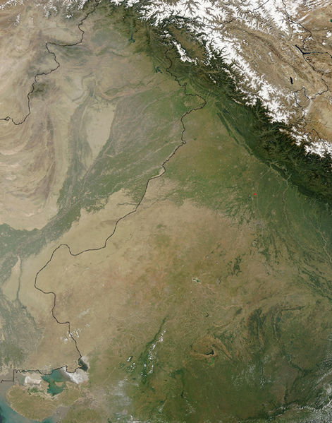
ფაილი:Thar Desert satellite.jpg

ზომა წინასწარი გადახედვისას: 471 × 599 პიქსელი. სხვა გაფართოება: 189 × 240 პიქსელი | 500 × 636 პიქსელი.
თავდაპირველი ფაილი ((500 × 636 პიქსელი, ფაილის ზომა: 329 კბ, MIME ტიპი: image/jpeg))
ფაილის ისტორია
დააწკაპუნეთ თარიღზე/დროზე ფაილის დასათვალიერებლად, როგორც ის მაშინ გამოიყურებოდა.
| თარიღი/დრო | მინიატიურა | ზომები | მომხმარებელი | შენიშვნა | |
|---|---|---|---|---|---|
| მიმდინარე | 14:25, 17 სექტემბერი 2005 |  | 500×636 (329 კბ) | Crux | Satellite Image of Thar Desert, India/Pakistan (border line in the middle) from en:, uploaded by en:User:Tom Radulovich |
ბმულები
ამ ფაილზე ბმული მოცემულია შემდეგ გვერდებზე:
ფაილის გლობალური გამოყენება
ეს ფაილი გამოიყენება შემდეგ ვიკებში:
- გამოყენება ar.wikipedia.org-ში
- გამოყენება az.wikipedia.org-ში
- გამოყენება bg.wikipedia.org-ში
- გამოყენება bn.wikipedia.org-ში
- გამოყენება bs.wikipedia.org-ში
- გამოყენება ckb.wikipedia.org-ში
- გამოყენება de.wikipedia.org-ში
- გამოყენება en.wikipedia.org-ში
- გამოყენება eo.wikipedia.org-ში
- გამოყენება es.wikipedia.org-ში
- გამოყენება et.wikipedia.org-ში
- გამოყენება fa.wikipedia.org-ში
- გამოყენება fi.wikipedia.org-ში
- გამოყენება fr.wikipedia.org-ში
- გამოყენება he.wikipedia.org-ში
- გამოყენება hu.wikipedia.org-ში
- გამოყენება it.wikipedia.org-ში
- გამოყენება ja.wikipedia.org-ში
- გამოყენება kk.wikipedia.org-ში
- გამოყენება kn.wikipedia.org-ში
- გამოყენება ko.wikipedia.org-ში
- გამოყენება ky.wikipedia.org-ში
- გამოყენება lfn.wikipedia.org-ში
- გამოყენება lt.wikipedia.org-ში
- გამოყენება mai.wikipedia.org-ში
- გამოყენება mg.wikipedia.org-ში
- გამოყენება mk.wikipedia.org-ში
- გამოყენება ml.wikipedia.org-ში
- გამოყენება mr.wikipedia.org-ში
- გამოყენება ms.wikipedia.org-ში
- გამოყენება ne.wikipedia.org-ში
- გამოყენება nn.wikipedia.org-ში
- გამოყენება pa.wikipedia.org-ში
- გამოყენება pl.wikipedia.org-ში
- გამოყენება pnb.wikipedia.org-ში
- გამოყენება pt.wikipedia.org-ში
იხილეთ, ამ ფაილის გლობალური გამოყენება.


