
ფაილი:Indian Rebellion of 1857.jpg

ზომა წინასწარი გადახედვისას: 713 × 599 პიქსელი. სხვა გაფართოება: 286 × 240 პიქსელი | 571 × 480 პიქსელი | 914 × 768 პიქსელი | 1 218 × 1 024 პიქსელი | 1 959 × 1 647 პიქსელი.
თავდაპირველი ფაილი ((1 959 × 1 647 პიქსელი, ფაილის ზომა: 2,82 მბ, MIME ტიპი: image/jpeg))
| ეს ფაილი მდებარეობს Wikimedia Commons სერვერზე. იხილეთ მისი აღწერის გვერდი სრული ინფორმაციისთვის. |
 |
გადასვლა ფაილის გვერდზე |
რეზიუმე
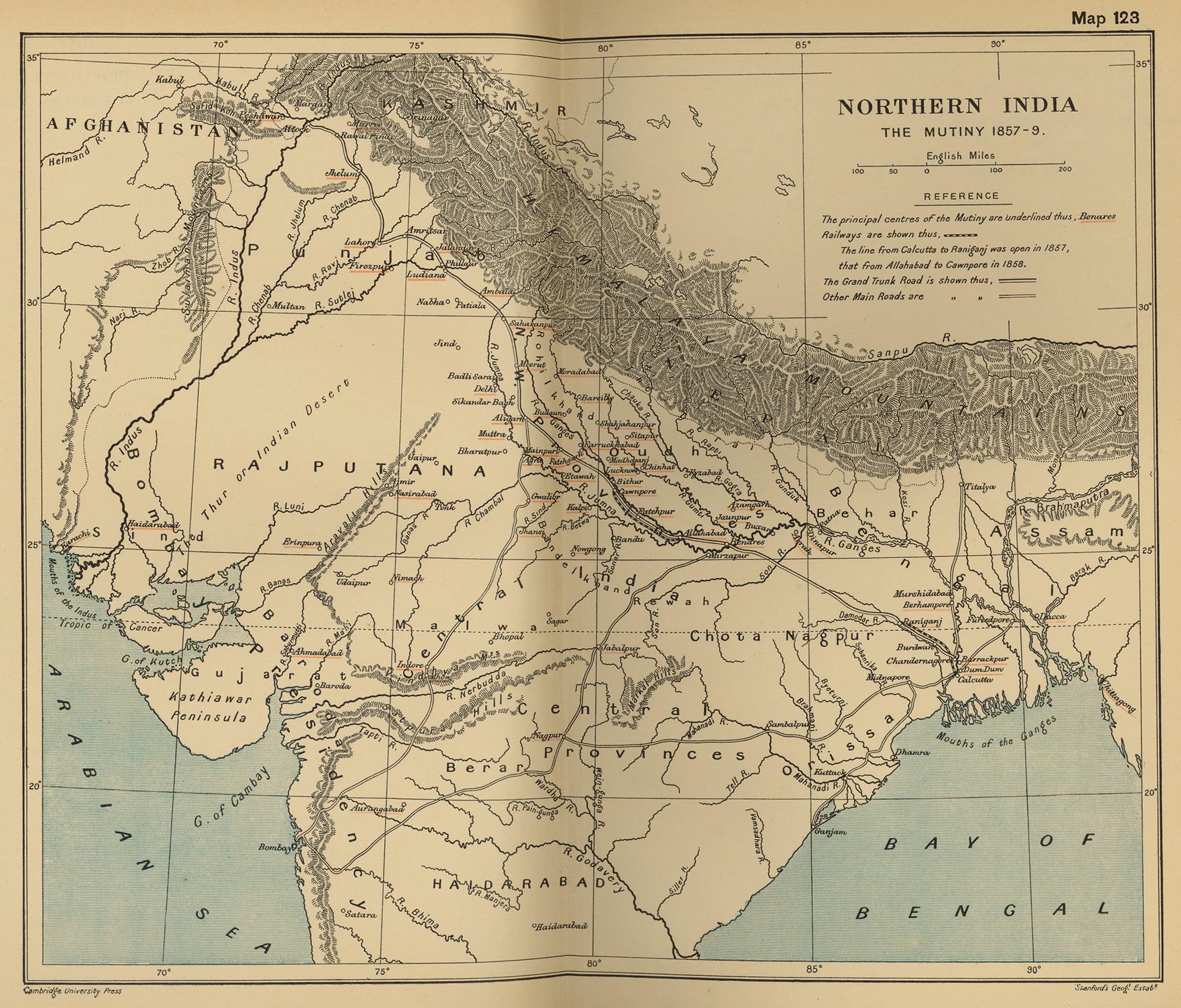
| Description |
English: Map, "North India: The Mutiny 1857-9" from "The Cambridge Modern History Atlas". Cambridge University Press; London. 1912.
Editors were Sir Adolphus William Ward (†1924), G.W. Prothero (†1922), and Sir Stanley Mordaunt Leathes (†1938). Individual authors of works making up the atlas are not identified, nor are the likely to be, after reasonable research. Español: Mapa del norte de India |
|||||||||
| თარიღი | ||||||||||
| წყარო | Perry-Castañeda Library Map Collection Website. | |||||||||
| შემქმნელი |
უცნობი Cambridge University Press; Stanford's Geogl. Estabt.. |
|||||||||
| Geotemporal data | ||||||||||
| Bounding box |
|
|||||||||
| Georeferencing | ||||||||||
| სხვა ვერსიები |
|
|||||||||

ლიცენზია
|
This is a faithful photographic reproduction of a two-dimensional, public domain work of art. The work of art itself is in the public domain for the following reason:
The official position taken by the Wikimedia Foundation is that "faithful reproductions of two-dimensional public domain works of art are public domain".
This photographic reproduction is therefore also considered to be in the public domain in the United States. In other jurisdictions, re-use of this content may be restricted; see Reuse of PD-Art photographs for details. | ||||
ატვირთვის ჟურნალი
The original description page was on en.wikipedia (file log). All following user names refer to en.wikipedia.
- 2010-06-06 08:35 PawełMM 1959×1647× (1118753 bytes) vertical strip shadorws removed
- 2010-06-05 12:13 PawełMM 1959×1647× (1201791 bytes) central verticaly part flattened, cropped
- 2008-03-05 02:51 Fowler&fowler 1992×1700× (683065 bytes) Map, "North India: The Mutiny 1857-9" from "The Cambridge Modern History Atlas" edited by Sir Adolphus William Ward, G.W. Prothero, Sir Stanley Mordaunt Leathes, and E.A. Benians. Cambridge University Press; London. 1912. Downloaded by ~~~~ from the [h
- 2008-03-05 02:37 Fowler&fowler 1992×1700× (715404 bytes) Map, "North India: The Mutiny 1857-9" from "The Cambridge Modern History Atlas" edited by Sir Adolphus William Ward, G.W. Prothero, Sir Stanley Mordaunt Leathes, and E.A. Benians. Cambridge University Press; London. 1912. Downloaded by ~~~~ from the [h
ფაილის ისტორია
დააწკაპუნეთ თარიღზე/დროზე ფაილის დასათვალიერებლად, როგორც ის მაშინ გამოიყურებოდა.
| თარიღი/დრო | მინიატიურა | ზომები | მომხმარებელი | შენიშვნა | |
|---|---|---|---|---|---|
| მიმდინარე | 15:35, 11 სექტემბერი 2012 | | 1 959×1 647 (2,82 მბ) | Yann | color balance, contrast, color corrections |
| 07:45, 18 ოქტომბერი 2010 |  | 1 959×1 647 (1,07 მბ) | File Upload Bot (Magnus Manske) | {{BotMoveToCommons|en.wikipedia|year={{subst:CURRENTYEAR}}|month={{subst:CURRENTMONTHNAME}}|day={{subst:CURRENTDAY}}}} {{Information |Description={{en|Map, "North India: The Mutiny 1857-9" from "The Cambridge Modern History Atlas" edited by Sir Adolphus |
ბმულები
ამ ფაილზე ბმული მოცემულია შემდეგ გვერდებზე:
ფაილის გლობალური გამოყენება
ეს ფაილი გამოიყენება შემდეგ ვიკებში:
- გამოყენება ar.wikipedia.org-ში
- გამოყენება ast.wikipedia.org-ში
- გამოყენება azb.wikipedia.org-ში
- გამოყენება bg.wikipedia.org-ში
- გამოყენება bh.wikipedia.org-ში
- გამოყენება bn.wikipedia.org-ში
- გამოყენება br.wikipedia.org-ში
- გამოყენება cs.wikipedia.org-ში
- გამოყენება cy.wikipedia.org-ში
- გამოყენება en.wikipedia.org-ში
- გამოყენება es.wikipedia.org-ში
- გამოყენება fr.wikipedia.org-ში
- გამოყენება hi.wikipedia.org-ში
- გამოყენება id.wikipedia.org-ში
- გამოყენება io.wikipedia.org-ში
- გამოყენება ja.wikipedia.org-ში
- გამოყენება lv.wikipedia.org-ში
- გამოყენება mai.wikipedia.org-ში
- გამოყენება mr.wikipedia.org-ში
- გამოყენება ms.wikipedia.org-ში
- გამოყენება ne.wikipedia.org-ში
- გამოყენება or.wikipedia.org-ში
- გამოყენება pa.wikipedia.org-ში
- გამოყენება pl.wikipedia.org-ში
- გამოყენება pnb.wikipedia.org-ში
- გამოყენება ru.wikipedia.org-ში
- გამოყენება sd.wikipedia.org-ში
- გამოყენება simple.wikipedia.org-ში
- გამოყენება sr.wikipedia.org-ში
- გამოყენება sv.wikipedia.org-ში
- გამოყენება ta.wikipedia.org-ში
- გამოყენება te.wikipedia.org-ში
- გამოყენება th.wikipedia.org-ში
- გამოყენება tr.wikipedia.org-ში
- გამოყენება ur.wikipedia.org-ში
იხილეთ, ამ ფაილის გლობალური გამოყენება.