
ფაილი:Byzantine Macedonia 1045CE.svg

თავდაპირველი ფაილი (ფაილი SVG, ნომინალურად 423 × 335 პიქსელი, ფაილის ზომა: 457 კბ)
| ეს ფაილი მდებარეობს Wikimedia Commons სერვერზე. იხილეთ მისი აღწერის გვერდი სრული ინფორმაციისთვის. |
 |
გადასვლა ფაილის გვერდზე |
Diese Karte stimmt nicht mit dem Historischen Atlas überein eine Fehlinformation.
რეზიუმე
| აღწერა |
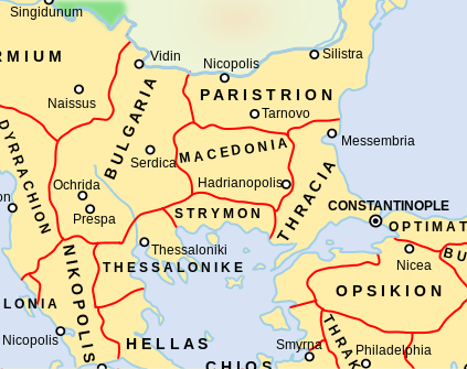
Català: Un mapa que mostra els temes bizantins (unitats administratives) de l'Imperi Bizantí l'any 1045 dC, centrat en els Balcans centrals al voltant de la regió de Macedònia. El tema macedoni es troba en el que avui forma part de l'actual Bulgària, mentre que el tema búlgar inclou el que avui és la República de Macedònia del Nord. Tingueu en compte que els límits temàtics d'aquest mapa, especialment els d'Estrímon i Macedònia, són molt inexactes. Macedònia es trobava realment més al sud, fins a la costa de l'Egeu de Tràcia occidental
English: A map showing the Byzantine themata (administrative units) of the Byzantine Empire in 1045 CE, focusing on central Balkans around the region of Macedonia. The Macedonian thema is in what today is part of present-day Bulgaria, while the Bulgarian thema includes what today is the Republic of North Macedonia. Note that the thematic boundaries in this map, especially those of Strymon and Macedonia, are very inaccurate. Macedonia was actually located further south, up to the Aegean coast of western Thrace |
| თარიღი | |
| წყარო | This is a derivative work of a more complete map created by ArdadN of the English Wikipedia. |
| ავტორი | NerdyNSK |
| უფლება (ფაილის მეორეული გამოყენება) |
GFDL-1.2+, CC-BY-SA-3.0/2.5/2.0/1.0 |
| სხვა ვერსიები |
This is a derivative work of a more complete map created by ArdadN of the English Wikipedia. File:Byzantine Macedonia 1045CE.svg has 2 translations.
Other related versions: []
|


|
ეს SVG ფაილი იყენებს თანდართულ ტექსტს, რომელიც ადვილად შეიძლება ითარგმნოს თქვენს ენაზე using [toolforge:svgtranslate/File:Byzantine_Macedonia_1045CE.svglink this automated tool]. გაიგეთ მეტი. You can also download it and translate it manually using a text editor. |
This file is translated using SVG For most Wikipedia projects, you can embed the file normally (without a To translate the text into your language, you can use the SVG Translate tool. Alternatively, you can download the file to your computer, add your translations using whatever software you're familiar with, and re-upload it with the same name. You will find help in Graphics Lab if you're not sure how to do this. |
ლიცენზია

|
თქვენ შეგიძიათ გაავრცელოთ ან შეცვალოთ დოკუმენტი GNU Free Documentation ლიცენზიის 1.2 ან უფრო გვიანდელი ვერსიის პირობების თანახმად, რომელიც გამოქვეყნებულია თავისუფალი პროგრამული უზრუნველყოფის ფონდის მიერ, შეუცვლელი განყოფილებების გარეშე, პირველ და ბოლო გვერდებზე განთავსებულ ტექსტებზე. ლიცენზიის ასლი არის განთავსებული განყოფილებაში სახელად GNU Free Documentation License. |
- თქვენ თავისუფლად შეგიძლიათ:
- ნამუშევრის გაზიარება – ნამუშევრის კოპირება, გავრცელება და გადაცემა.
- შექმნათ დაფუძნებულები – ნამუშევრის შესწორება
- შემდეგი პირობებით:
- მოხსენიება – თქვენ უნდა მიუთითოთ წყაროს შემქმნელი იმ გზით, რომელიც დანიშნა ავტორმა ან საავტორო უფლებების მფლობელმა. მაგრამ არა ისე, თითქოს წყაროს ავტორი მხარს გიჭერთ თქვენ ან დაუჭირა თქვენს მიერ შექმნილ ნაწარმოებს.
- გავრცელება იგივე პირობებეით – თუ თქვენ ცვლით, ან ქმნით ახალ ნაშრომს ამ ნამუშევრის გამოყენებთ, თქვენ გაქვთ უფლება გაავრცელოთ იგი იგივე ან შესაბამისი ლიცენზიით, რომლითაც ვრცელდება წყარო.
ფაილის ისტორია
დააწკაპუნეთ თარიღზე/დროზე ფაილის დასათვალიერებლად, როგორც ის მაშინ გამოიყურებოდა.
| თარიღი/დრო | მინიატიურა | ზომები | მომხმარებელი | შენიშვნა | |
|---|---|---|---|---|---|
| მიმდინარე | 16:05, 11 თებერვალი 2024 | | 423×335 (457 კბ) | Manlleus | File uploaded using svgtranslate tool (https://svgtranslate.toolforge.org/). Added translation for ca. |
| 07:58, 10 თებერვალი 2024 |  | 423×335 (457 კბ) | Leptictidium | File uploaded using svgtranslate tool (https://svgtranslate.toolforge.org/). Added translation for ca. | |
| 07:50, 10 თებერვალი 2024 |  | 423×335 (457 კბ) | Leptictidium | File uploaded using svgtranslate tool (https://svgtranslate.toolforge.org/). Added translation for ca. | |
| 19:52, 9 თებერვალი 2024 |  | 423×335 (447 კბ) | Manlleus | added catalan language | |
| 21:30, 4 მაისი 2017 |  | 423×335 (407 კბ) | Kandi | Reverted to version as of 05:00, 4 April 2008 (UTC) | |
| 21:15, 4 მაისი 2017 |  | 4 252×6 013 (317 კბ) | Kandi | new, more detailed version | |
| 05:00, 4 აპრილი 2008 |  | 423×335 (407 კბ) | NerdyNSK | {{Information |Description=A map showing the Byzantine themata (administrative units) of the Byzantine Empire in 1045 CE, focusing on central Balkans around the region of Macedonia. The Macedonian thema is in what today is part of present-day Bulgaria, w |
ბმულები
ამ ფაილზე ბმული მოცემულია შემდეგ გვერდებზე:
ფაილის გლობალური გამოყენება
ეს ფაილი გამოიყენება შემდეგ ვიკებში:
- გამოყენება als.wikipedia.org-ში
- გამოყენება ar.wikipedia.org-ში
- გამოყენება azb.wikipedia.org-ში
- გამოყენება ba.wikipedia.org-ში
- გამოყენება be.wikipedia.org-ში
- გამოყენება bg.wikipedia.org-ში
- გამოყენება ca.wikipedia.org-ში
- გამოყენება cs.wikipedia.org-ში
- გამოყენება de.wikipedia.org-ში
- გამოყენება el.wikipedia.org-ში
- გამოყენება en.wikipedia.org-ში
- გამოყენება fr.wikipedia.org-ში
იხილეთ, ამ ფაილის გლობალური გამოყენება.