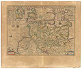
ფაილი:Blaeu 1645 - Ducatus Holsatiæ nova tabula.jpg

გვერდი სხვა ენებზე არ არის ხელმისაწვდომი.
მასალა ვიკიპედიიდან — თავისუფალი ენციკლოპედია

თავდაპირველი ფაილი((3 646 × 3 083 პიქსელი, ფაილის ზომა: 4,54 მბ, MIME ტიპი: image/jpeg))

ეს ფაილი მდებარეობს Wikimedia Commons სერვერზე.
იხილეთ მისი აღწერის გვერდი სრული ინფორმაციისთვის.
გადასვლა ფაილის გვერდზე

რეზიუმე

სათაური
Ducatus Holsatiæ nova tabula (New map of the Duchy of Holstein.)
from
"Theatrum Orbis Terrarum, sive Atlas Novus in quo Tabulæ et Descriptiones Omnium Regionum, Editæ a Guiljel et Ioanne Blaeu"
(Theater of the World, or a New Atlas of Maps and Representations of All Regions, Edited by Willem and Joan Blaeu), 1645.
წყარო University of California
Georeferencing Georeference the map in Wikimaps Warper If inappropriate please set warp_status = skip to hide.
სხვა ვერსიები


ლიცენზია

Public domain

This work is in the public domain in its country of origin and other countries and areas where the copyright term is the author's life plus 70 years or fewer.


You must also include a United States public domain tag to indicate why this work is in the public domain in the United States. Note that a few countries have copyright terms longer than 70 years: Mexico has 100 years, Jamaica has 95 years, Colombia has 80 years, and Guatemala and Samoa have 75 years. This image may not be in the public domain in these countries, which moreover do not implement the rule of the shorter term. Honduras has a general copyright term of 75 years, but it does implement the rule of the shorter term. Copyright may extend on works created by French who died for France in World War II (more information), Russians who served in the Eastern Front of World War II (known as the Great Patriotic War in Russia) and posthumously rehabilitated victims of Soviet repressions (more information).

Captions

Add a one-line explanation of what this file represents

media type ინგლისური

image/jpeg

checksum ინგლისური

5eadcd5c2ea71050d9e2fb315157f30c357802d8

data size ინგლისური

4764833 ბაიტი

ფაილის ისტორია

დააწკაპუნეთ თარიღზე/დროზე ფაილის დასათვალიერებლად, როგორც ის მაშინ გამოიყურებოდა.

თარიღი/დრომინიატიურაზომებიმომხმარებელიშენიშვნა
მიმდინარე21:22, 17 იანვარი 2007მინიატურა 21:22, 17 იანვარი 2007 ვერსიისთვის3 646×3 083 (4,54 მბ)Simplicius== Summary == ; Title : '''''Ducatus Holsatiæ nova tabula''''' (''New map of the Duchy of Holstein.'')<br>from<br>"Theatrum Orbis Terrarum, sive Atlas Novus in quo Tabulæ et Descriptiones Omnium Regionum, Editæ a Guiljel et Ioanne Blaeu"<br>(''Theater

ამ ფაილზე ბმული მოცემულია შემდეგ გვერდებზე:

ფაილის გლობალური გამოყენება

ეს ფაილი გამოიყენება შემდეგ ვიკებში:

მეტამონაცემები